Fájl:Beginning Point of the U.S. Public Land Survey front.jpg

Az előnézet mérete: 450 × 600 képpont További felbontások: 180 × 240 képpont | 360 × 480 képpont | 576 × 768 képpont | 768 × 1 024 képpont | 2 112 × 2 816 képpont.
Eredeti fájl (2 112 × 2 816 képpont, fájlméret: 3,37 MB, MIME-típus: image/jpeg)
|
Ez a fájl a Wikimedia Commonsból származik. Az alább látható leírás az ottani dokumentációjának másolata. A Commons projekt szabad licencű kép- és multimédiatár. Segíts te is az építésében! |
|
This is an image of a place or building that is listed on the National Register of Historic Places in the United States of America. Its reference number is 66000606. |
| Fényképező elhelyezkedése | | További képek erről a helyről: OpenStreetMap |
|---|
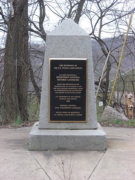
| Leírás | Streetside view of the Beginning Point of the U.S. Public Land Survey, a monument marking the site that served as the basis for the entire Public Land Survey System — the system by which most of the United States, outside of the original colonies, was surveyed. Located on the Ohio/Pennsylvania border east of downtown East Liverpool, Ohio, it is split between the city of East Liverpool and the borough of Ohioville in Beaver County, Pennsylvania. Erected in 1881 by a joint commission of Ohio and Pennsylvania surveyors, the monument was declared a National Historic Landmark in 1966. The road on which it lies is Ohio State Route 39 and Pennsylvania Route 68. | ||
| Dátum | Készült: 2009. március 28. | ||
| Forrás | A feltöltő saját munkája | ||
| Szerző | User:Nyttend | ||
| Engedély (Fájl újrafelhasználása) |
|
||
| Más változatok |
 Ohio and Ohio and  Pennsylvania sides of the monument Pennsylvania sides of the monument |
Fájltörténet
Kattints egy időpontra, hogy a fájl akkori állapotát láthasd.
| Dátum/idő | Bélyegkép | Felbontás | Feltöltő | Megjegyzés | |
|---|---|---|---|---|---|
| aktuális | 2009. március 28., 06:29 | | 2 112 × 2 816 (3,37 MB) | Nyttend | {{Location|40|38|33|N|80|31|10|W}} {{Information |Description=Streetside view of the {{w|Beginning Point of the U.S. Public Land Survey}}, a monument marking the site that served as the basis for the entire {{w|Public Land Survey System}} — the system b |
Fájlhasználat
Az alábbi lap használja ezt a fájlt:
Globális fájlhasználat
A következő wikik használják ezt a fájlt:
- Használata itt: ca.wikipedia.org
- Használata itt: de.wikipedia.org
- Használata itt: en.wikipedia.org
- Public Land Survey System
- List of Historic Civil Engineering Landmarks
- Point of beginning
- List of National Historic Landmarks in Pennsylvania
- List of National Historic Landmarks in Ohio
- Beginning Point of the U.S. Public Land Survey
- National Register of Historic Places listings in Columbiana County, Ohio
- National Register of Historic Places listings in Beaver County, Pennsylvania
- List of Pennsylvania state historical markers in Beaver County
- User talk:Dthomsen8/List PA Test
- Használata itt: en.wikivoyage.org
- Használata itt: es.wikipedia.org
- Használata itt: fr.wikipedia.org
- Használata itt: it.wikipedia.org
- Használata itt: ja.wikipedia.org
- Használata itt: pt.wikipedia.org
- Használata itt: tl.wikipedia.org
- Használata itt: ur.wikipedia.org
- Használata itt: vi.wikipedia.org
- Használata itt: www.wikidata.org