Fájl:Map administrative divisions of the First French Empire 1812-en.svg

Eredeti fájl (SVG fájl, névlegesen 2 052 × 1 728 képpont, fájlméret: 3,86 MB)
|
Ez a fájl a Wikimedia Commonsból származik. Az alább látható leírás az ottani dokumentációjának másolata. A Commons projekt szabad licencű kép- és multimédiatár. Segíts te is az építésében! |
Összefoglaló
| Leírás |
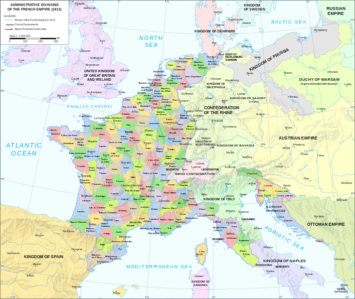
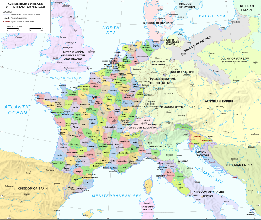
Català: Divisions administratives del Primer Imperi Francès el 1812
English: Administrative divisions of the First French Empire in 1812 |
| Dátum | |
| Forrás |
|
| Szerző | Andrein |
| Más változatok |
Other related versions:[]
|


|
Ez az SVG-fájl beágyazott szöveget tartalmaz, amit könnyen magyarra lehetne fordítani a bármilyen megfelelő SVG- vagy szövegszerkesztővel, vagy az SVG-fordító eszközzel. További információkért lásd: SVG-fájlok fordítása. |
A fájl SVG <switch> elemek segítségével van lefordítva. Minden fordítás egy fájlban van! További információ
A legtöbb Wikipédián a fájl a szokásos módon (a A fájl szöveges tartalmának lefordításához használhatod az SVG-fordító eszközt, vagy letöltheted a számítógépedre, hozzáadhatod a fordításodat a kedvenc eszközöddel, majd feltöltheted ugyanezen a néven. Segítséget kérhetsz Grafikai Laborban, ha nem vagy biztos, hogyan kell csinálni. |
Licenc
- A következőket teheted a művel:
- megoszthatod – szabadon másolhatod, terjesztheted, bemutathatod és előadhatod a művet
- feldolgozhatod – származékos műveket hozhatsz létre
- Az alábbi feltételekkel:
- Nevezd meg! – A szerzőt megfelelően fel kell tüntetned, hivatkozást kell létrehoznod a licencre és jelezned kell, ha a művön változtatást hajtottál végre. Ezt bármilyen észszerű módon megteheted, kivéve oly módon, ami azt sugallná hogy a jogosult támogat téged vagy a felhasználásod körülményeit.
- Így add tovább! – Ha megváltoztatod, átalakítod, feldolgozod ezt a művet, a közreműködésedet csak az eredetivel megegyező vagy hasonló licenc alatt terjesztheted.
Fájltörténet
Kattints egy időpontra, hogy a fájl akkori állapotát láthasd.
| Dátum/idő | Bélyegkép | Felbontás | Feltöltő | Megjegyzés | |
|---|---|---|---|---|---|
| aktuális | 2024. február 9., 14:33 | | 2 052 × 1 728 (3,86 MB) | Manlleus | added catalan language |
| 2021. május 21., 19:10 |  | 2 052 × 1 728 (3,55 MB) | Andrei Stroe | File uploaded using svgtranslate tool (https://svgtranslate.toolforge.org/). Added translation for ro. | |
| 2020. augusztus 30., 14:32 |  | 2 052 × 1 728 (3,24 MB) | Jfblanc | File uploaded using svgtranslate tool (https://svgtranslate.toolforge.org/). Added translation for oc. | |
| 2018. március 1., 12:37 |  | 2 052 × 1 728 (2,83 MB) | Imperator Honorius | Formatting Fix | |
| 2018. március 1., 12:29 |  | 2 052 × 1 728 (2,83 MB) | Imperator Honorius | Formatting and missing Anglicization (Gand to Ghent) | |
| 2018. március 1., 12:17 |  | 2 052 × 1 728 (2,83 MB) | Imperator Honorius | Spelling and typos; more Anglicised (and up to date) city names. | |
| 2015. július 20., 21:41 |  | 2 052 × 1 728 (2,82 MB) | ArdadN | spelling | |
| 2015. július 20., 19:11 |  | 2 052 × 1 728 (2,81 MB) | ArdadN | 1 | |
| 2015. július 20., 19:05 |  | 2 052 × 1 728 (2,81 MB) | ArdadN | font size | |
| 2015. július 20., 18:06 |  | 2 052 × 1 728 (2,81 MB) | ArdadN | 1 |
Fájlhasználat
Ezt a fájlt nem használja egyetlen lap sem.
Globális fájlhasználat
A következő wikik használják ezt a fájlt:
- Használata itt: af.wikipedia.org
- Használata itt: ar.wikipedia.org
- Használata itt: ca.wikipedia.org
- Használata itt: en.wikipedia.org
- History of the Netherlands
- 1810s
- Departments of France
- 130 departments of the First French Empire
- Illyrian Provinces
- Kingdom of Italy (Napoleonic)
- Portal:Maps/Maps/Political
- Portal:Maps/Maps/Political/14
- First French Empire
- Bouches-del'Èbre
- Department of Segre
- Left Bank of the Rhine
- User:Dakaysaa/sandbox
- User:Falcaorib/France
- Használata itt: et.wikipedia.org
- Használata itt: fr.wikipedia.org
- Használata itt: hr.wikipedia.org
- Használata itt: it.wikipedia.org
- Használata itt: ka.wikipedia.org
- Használata itt: km.wikipedia.org
- Használata itt: no.wikipedia.org
- Használata itt: pl.wikipedia.org
- Használata itt: pnb.wikipedia.org
- Használata itt: pt.wikipedia.org
- Használata itt: ru.wikipedia.org
- Használata itt: tr.wikipedia.org
- Használata itt: ur.wikipedia.org
- Használata itt: vi.wikipedia.org