Fájl:Gilman (United States (after the Treaty of Guadalupe Hidalgo)) 1848 UTA.jpg

Az előnézet mérete: 800 × 340 képpont További felbontások: 320 × 136 képpont | 640 × 272 képpont | 1 024 × 435 képpont | 1 280 × 544 képpont | 3 417 × 1 453 képpont.
Eredeti fájl (3 417 × 1 453 képpont, fájlméret: 7,6 MB, MIME-típus: image/jpeg)
|
Ez a fájl a Wikimedia Commonsból származik. Az alább látható leírás az ottani dokumentációjának másolata. A Commons projekt szabad licencű kép- és multimédiatár. Segíts te is az építésében! |
Összefoglaló
| Cím |
English: [United States (after the Treaty of Guadalupe Hidalgo)] |
||||||||||||||||||||||||||
| Leírás |
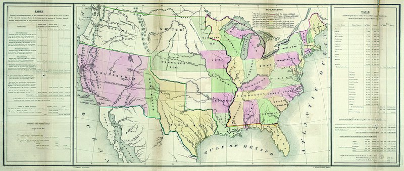
English: By the Treaty of Guadalupe Hidalgo at the end of the U.S. War with Mexico in 1848, the United States received the former Mexican territories of Upper California and New Mexico and confirmed its claim to Texas. This map from President Polk's printed review of the year shows new and old boundaries, noting when and by which treaties these were established. The southwestern boundary, stretching west from El Paso, would prove a difficult problem in the coming years, established as it was during the treaty negotiations between the U.S. and Mexican diplomats on the basis of different editions of a faulty map – the Disturnell map of Mexico of 1847. The table at left documents the total estimated square miles, acreage, and miles of coastline acquired as well as the previously existing statistics for the nation and its various territories. Ominously, the table at right explains the square mileage and acreage of both the free and slave states and territories, documenting a critical area of contention that would ultimately lead to civil war. |
||||||||||||||||||||||||||
| Dátum | |||||||||||||||||||||||||||
| Forrás | UTA Libraries Cartographic Connections: térkép / text | ||||||||||||||||||||||||||
| Alkotó |
E. Gilman |
||||||||||||||||||||||||||
| Származás |
English: UTA Libraries Special Collections |
||||||||||||||||||||||||||
| Geotemporal data | |||||||||||||||||||||||||||
| Map location | Amerikai Egyesült Államok | ||||||||||||||||||||||||||
| Georeferencing | If inappropriate please set warp_status = skip to hide. | ||||||||||||||||||||||||||
| Bibliographic data | |||||||||||||||||||||||||||
| Kiadvány |
Message of the President for 1848 (30th Cong., 2nd Sess., House Ex. Doc. No. 1) |
||||||||||||||||||||||||||
| Szerző |
|
||||||||||||||||||||||||||
| Kiadás helye | Washington | ||||||||||||||||||||||||||
| Nyomda |
P.S. Duval, Philadelphia |
||||||||||||||||||||||||||
| Archival data | |||||||||||||||||||||||||||
| Gyűjtemény |
|
||||||||||||||||||||||||||
| Méretei | magasság: 36 cm; szélesség: 85,5 cm | ||||||||||||||||||||||||||
| Technika | színezett litográfia (kőnyomat) | ||||||||||||||||||||||||||
| artwork-references | Wheat Mapping the Trans-Mississippi West, 3, no. 561 , 50, 265 o. | ||||||||||||||||||||||||||

)_1848_UTA.jpg)
Licenc

|
This file was provided to Wikimedia Commons by the University of Texas at Arlington Libraries as part of a cooperation project. The University of Texas at Arlington Libraries is part of the University of Texas at Arlington, a public research university located in Arlington, Texas.
|
Ez az alkotás az Amerikai Egyesült Államokban közkincsnek számít, mivel 1929. január 1. előtt publikálták.
A közkincsnek számító munkáknak mind az Egyesült Államokban, mind a származási országban ki kell kerülniük a szerzői jogokat védő törvények hatálya alól. Ha egy alkotás nem az Egyesült Államokban készült, akkor a származási országban érvényben lévő szerzői jogi státuszát is közölni kell.
|
Fájltörténet
Kattints egy időpontra, hogy a fájl akkori állapotát láthasd.
| Dátum/idő | Bélyegkép | Felbontás | Feltöltő | Megjegyzés | |
|---|---|---|---|---|---|
| aktuális | 2022. március 11., 19:43 | | 3 417 × 1 453 (7,6 MB) | Michael Barera | == {{int:filedesc}} == {{Map |title = {{en|'''''[United States (after the Treaty of Guadalupe Hidalgo)]'''''}} |description = {{en|By the Treaty of Guadalupe Hidalgo at the end of the U.S. War with Mexico in 1848, the United States received the former Mexican territories of Upper California and New Mexico and confirmed its claim to Texas. This map from President Polk's printed review of the year shows new and old boundaries, noting when and by which treaties these were est... |
Fájlhasználat
Az alábbi lap használja ezt a fájlt:
Globális fájlhasználat
A következő wikik használják ezt a fájlt:
- Használata itt: en.wikipedia.org
- Használata itt: es.wikipedia.org
- Használata itt: ko.wikipedia.org
)_1848_UTA.jpg)