Fájl:India southwest summer monsoon onset map en.svg

Eredeti fájl (SVG fájl, névlegesen 1 639 × 1 852 képpont, fájlméret: 656 KB)
|
Ez a fájl a Wikimedia Commonsból származik. Az alább látható leírás az ottani dokumentációjának másolata. A Commons projekt szabad licencű kép- és multimédiatár. Segíts te is az építésében! |
| Cím |
India climatic zone map english version |
|||||||||
| Leírás |
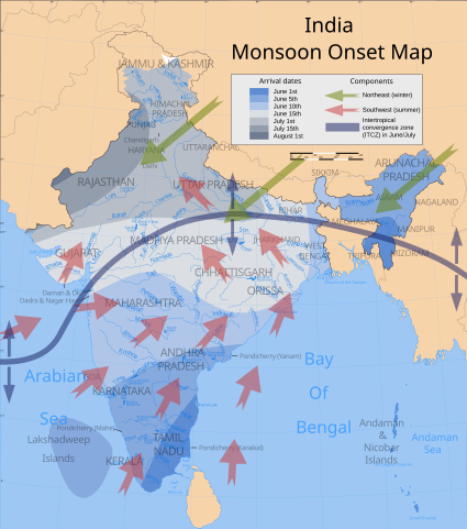
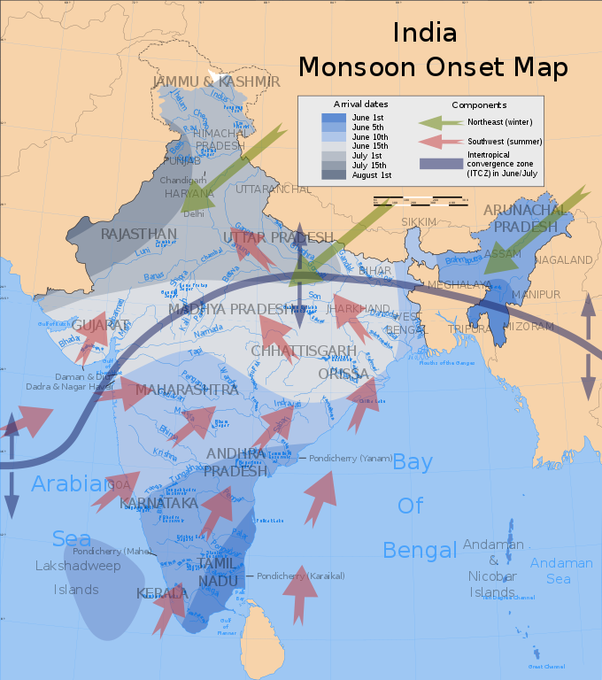
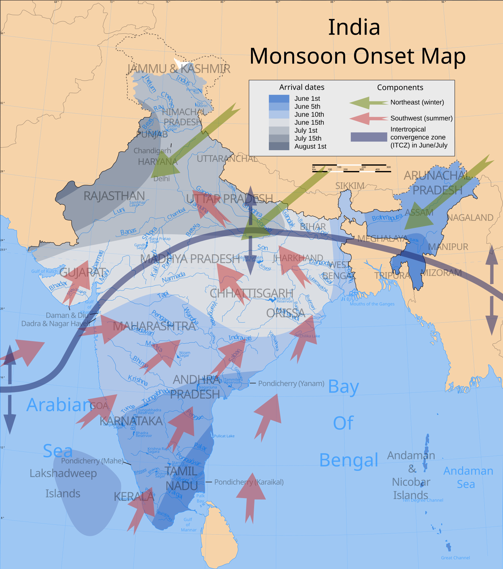
Map showing average onset (monsoon arrival) dates and wind directions prevalent during India's southwest summer monsoon. |
|||||||||
| Map legend |
 |
|||||||||
| Dátum | ||||||||||
| Forrás |
A feltöltő saját munkája Wind currents/ITCZ: Burroughs, WJ (1999), The Climate Revealed, Cambridge University Press, ISBN 0-521-77081-5, p. 138. |
|||||||||
| Alkotó | ||||||||||
| Engedély (Fájl újrafelhasználása) |
Én, e mű szerzője a művemet az alábbi licenc alatt teszem közzé: Ez a fájl a Creative Commons Nevezd meg! – Így add tovább! 3.0 Unported licenc alapján használható fel.
|
|||||||||
| Geotemporal data | ||||||||||
| Ábrázolt időpont | 20. évszázad második felében és 21. évszázad | |||||||||
| Spatial reference system | conic | |||||||||
| Bounding box |
|
|||||||||
| Georeferencing | If inappropriate please set warp_status = skip to hide. | |||||||||
| Archival data | ||||||||||
| Megjegyzés | Part of WikiProject India Maps | |||||||||
| SVG kód | Ez vektorgrafikus kép Adobe Illustrator segítségével készült |
|||||||||
| Más változatok | Származékos művek: India southwest summer monsoon onset map-fr.svg | |||||||||


Notes
Depiction of India's borders
- The territorial boundaries of India are shown as per the actual ground situation in accordance with international practices followed by the United Nations ([1], [2]) and the National Geographic Society ([3], [4])
- This map is meant to be for illustrative purpose only and is not authenticated by official government sources. Please check the list of sources and references used to create the map for a measure of accuracy and verifiability.
- The usage of these maps in India, Pakistan and China are governed by different laws that restrict depictions of boundaries other than what is officially recognized by the state. Please check local laws and modify the map accordingly before use.
Explanation of disputed boundaries


- Boundary of Indian claim : The territory India claims is legally theirs, but the claim is disputed by China and Pakistan.
- Line of Control/Line of Conflict : The de facto administrative boundary recognised by the international community. This UN ceasefire line is considered as a temporary solution to an ongoing conflict since the departure of the British Raj.
Borders of disputed regions
The depicted extent of the former territory of the British Indian Empire, succeeded by Republic of India, may not be accepted by few countries as legal due to ongoing border disputes:
- The northern Himalayan region of the disputed territory Indian-administered Kashmir is claimed by India including (Pakistan-administered Kashmir) and the Chinese-occupied territory of (Ladakh plateau). Since 1972, it is divided between all three countries. See also Line of Control and Line of Actual Control.
- Siachen glacier (shown white) is an actively contested region between India and Pakistan. Since 1984, the region is under Indian control.
- The northeastern territory of Arunachal Pradesh is almost entirely claimed by China as part of its Tibetan territory.
- Minor areas of eastern Kashmir's Ladakh division, Himachal Pradesh and Uttarakhand on the Chinese frontier are claimed by China. These areas are under Indian control.
- A small area of Uttarakhand adjoining the Nepal border along the Sarda river is disputed between the two countries.
For a detailed map of all disputed regions in South Asia, see Image:India disputed areas map.svg
Internal borders
The borders of the state of Meghalaya, Assam and Arunachal Pradesh are shown as interpreted from the North-Eastern Areas (Reorganisation) Act, 1971, but has yet to be verified.
Territorial waters
The limit of the territorial waters of India extends to twelve nautical miles measured from the appropriate baseline. See this for more information.
| Képjegyzetek | Ehhez a képhez képjegyzetek tartoznak: Képjegyzetek megtekintése a Commonson |
Fájltörténet
Kattints egy időpontra, hogy a fájl akkori állapotát láthasd.
| Dátum/idő | Bélyegkép | Felbontás | Feltöltő | Megjegyzés | |
|---|---|---|---|---|---|
| aktuális | 2007. július 3., 22:57 | | 1 639 × 1 852 (656 KB) | Saravask | {{WikiProject_India_Maps |Title=India climatic zone map english version |Description=Map (corrected) showing average onset (monsoon arrival) dates and wind directions prevalent during India's southwest summer monsoon. |Source=''Onset dates:'' [http://www. |
| 2007. április 24., 02:01 |  | 1 639 × 1 852 (656 KB) | Saravask | {{WikiProject_India_Maps |Title=India climatic zone map english version |Description=Map showing average onset (monsoon arrival) dates and wind directions prevalent during India's southwest summer monsoon. |Source=''Onset dates:'' [http://www.imdmumbai.go | |
| 2007. április 24., 01:19 |  | 1 639 × 1 852 (651 KB) | Saravask | {{WikiProject_India_Maps |Title=India climatic zone map english version |Description=Map showing average onset (monsoon arrival) dates and wind directions prevalent during India's southwest summer monsoon. |Source=''Onset dates:'' [http://www.imdmumbai.go | |
| 2007. április 24., 00:59 |  | 1 639 × 1 852 (651 KB) | Saravask | {{WikiProject_India_Maps |Title=India climatic zone map english version |Description=Map showing average onset (monsoon arrival) dates and wind directions prevalent during India's southwest summer monsoon. |Source=''Onset dates:'' [http://www.imdmumbai.go | |
| 2007. március 26., 16:00 |  | 1 639 × 1 852 (649 KB) | Saravask | {{WikiProject_India_Maps |Title=India climatic zone map english version |Description=Map showing climatic zones in India (Köppen classification) |Source= [http://www.imdmumbai.gov.in/Onset.htm Normal dates of onset of | |
| 2007. március 26., 15:48 |  | 1 639 × 1 852 (649 KB) | Saravask | {{WikiProject_India_Maps |Title=India climatic zone map english version |Description=Map showing climatic zones in India (Köppen classification) |Source= [http://www.imdmumbai.gov.in/Onset.htm Normal dates of onset of | |
| 2007. március 26., 15:27 |  | 1 639 × 1 852 (649 KB) | Saravask | {{WikiProject_India_Maps |Title=India climatic zone map english version |Description=Map showing climatic zones in India (Köppen classification) |Source= [http://cee45q.stanford.edu/2003/briefing_book/images/india_cli |
Fájlhasználat
Az alábbi lap használja ezt a fájlt:
Globális fájlhasználat
A következő wikik használják ezt a fájlt:
- Használata itt: ar.wikipedia.org
- Használata itt: bh.wikipedia.org
- Használata itt: ca.wikipedia.org
- Használata itt: cs.wikipedia.org
- Használata itt: de.wikipedia.org
- Használata itt: dty.wikipedia.org
- Használata itt: el.wikipedia.org
- Használata itt: en.wikipedia.org
- Használata itt: en.wikibooks.org
- Használata itt: eu.wikipedia.org
- Használata itt: fa.wikipedia.org
- Használata itt: fr.wikipedia.org
- Használata itt: hi.wikipedia.org
- Használata itt: hy.wikipedia.org
- Használata itt: incubator.wikimedia.org
- Használata itt: it.wikipedia.org
- Használata itt: it.wikibooks.org
- Használata itt: ja.wikipedia.org
- Használata itt: kn.wikipedia.org
- Használata itt: mk.wikipedia.org
- Használata itt: ml.wikipedia.org
- Használata itt: ms.wikipedia.org
- Használata itt: ne.wikipedia.org
- Használata itt: nl.wikipedia.org
- Használata itt: nn.wikipedia.org
- Használata itt: pa.wikipedia.org
- Használata itt: pnb.wikipedia.org
- Használata itt: pt.wikipedia.org
A fájl globális használatának megtekintése