Fájl:Karta ID Maluku isl.PNG
Nem érhető el nagyobb felbontású változat.
Karta_ID_Maluku_isl.PNG (348 × 348 képpont, fájlméret: 4 KB, MIME-típus: image/png)
|
Ez a fájl a Wikimedia Commonsból származik. Az alább látható leírás az ottani dokumentációjának másolata. A Commons projekt szabad licencű kép- és multimédiatár. Segíts te is az építésében! |
Összefoglaló
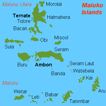
| Leírás |
English: Map (rough) of Maluku islands, Indonesia, own work composed from various mapreferences |
| Dátum | |
| Forrás | A feltöltő saját munkája |
| Szerző | Hobe / Holger Behr |
| Más változatok | Származékos művek: Maluku Islands international.png |
Licenc
| Én, a szerző, ezt a művemet ezennel közkinccsé nyilvánítom. Ez a világ minden részén érvényes. Egyes országokban ez jogilag nem lehetséges. Ha így van, akkor: Jogot adok bárkinek, hogy bármilyen célból, feltétel nélkül használhassa ezt a fájlt, kivéve a törvény által kötelezően előírt feltételeket. |
-
Fájltörténet
Kattints egy időpontra, hogy a fájl akkori állapotát láthasd.
| Dátum/idő | Bélyegkép | Felbontás | Feltöltő | Megjegyzés | |
|---|---|---|---|---|---|
| aktuális | 2018. február 26., 15:50 | | 348 × 348 (4 KB) | Sebastian Wallroth | Removed border by cropping 1 % horizontally and 1 % vertically using CropTool with precise mode. |
| 2007. július 3., 12:00 |  | 350 × 350 (7 KB) | Hobe | {{Information |Description=map Maluku islands, Indonesia |Source=self-made |Date=2007-07-01 |Author= Hobe Category:Maps of Indonesia }} | |
| 2007. május 4., 10:25 |  | 350 × 350 (7 KB) | Hobe | {{Information |Description=map Maluku islands, Indonesia, new version |Source=self made, composed from various mapreferences |Date=2007-05-04 |Author=Holger Behr }} | |
| 2007. május 4., 10:22 |  | 350 × 350 (7 KB) | Hobe | {{Information |Description=map Maluku islands, Indonesia, new version |Source=self-made, composed from various mapreferences |Date=2007-0425 |Author= User:Hobe }} | |
| 2007. május 3., 12:15 |  | 350 × 350 (7 KB) | Hobe | {{Information |Description=map Maluku islands, Indonesia |Source=own work, composed from various mapreferences |Date=2007-04-25 |Author=Holger Behr }} |
Fájlhasználat
Ezt a fájlt nem használja egyetlen lap sem.
Globális fájlhasználat
A következő wikik használják ezt a fájlt:
- Használata itt: als.wikipedia.org
- Használata itt: ar.wikipedia.org
- Használata itt: arz.wikipedia.org
- Használata itt: az.wikipedia.org
- Használata itt: bcl.wikipedia.org
- Használata itt: be-tarask.wikipedia.org
- Használata itt: be.wikipedia.org
- Használata itt: ca.wikipedia.org
- Használata itt: de.wikipedia.org
- Használata itt: en.wikipedia.org
- Használata itt: eo.wikipedia.org
- Használata itt: es.wikipedia.org
- Használata itt: eu.wikipedia.org
- Használata itt: fa.wikipedia.org
- Használata itt: fr.wikipedia.org
A fájl globális használatának megtekintése