Fájl:Pascatway River New England.jpg
Eredeti fájl (3 440 × 2 448 képpont, fájlméret: 749 KB, MIME-típus: image/jpeg)
|
Ez a fájl a Wikimedia Commonsból származik. Az alább látható leírás az ottani dokumentációjának másolata. A Commons projekt szabad licencű kép- és multimédiatár. Segíts te is az építésében! |
Összefoglaló
| Leírás |
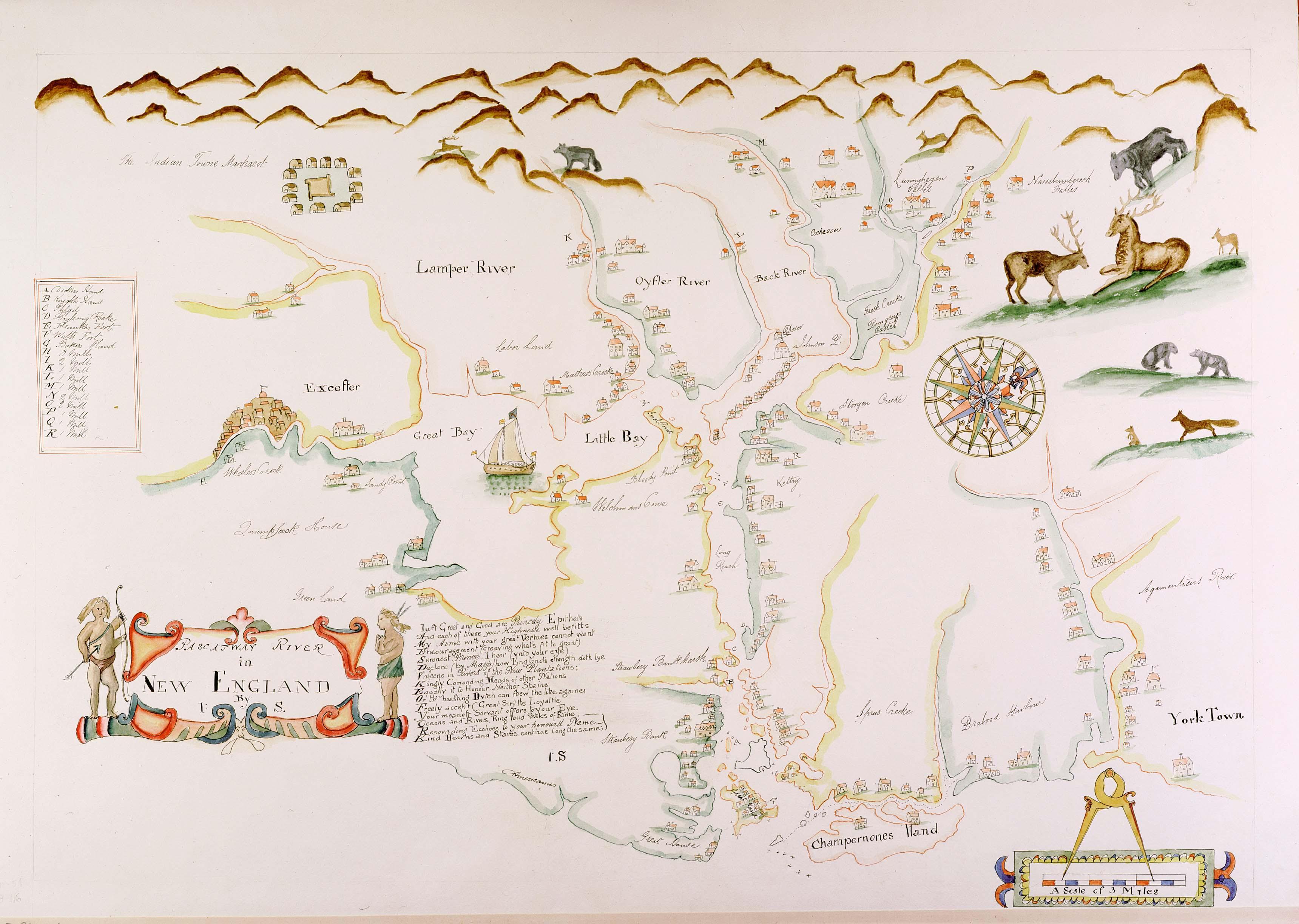
English: Maine historian James Phinney Baxter commissioned the map to be copied from the original in the late 19th century. The original surveyor and creator of the map is unknown, except that the original map carries the initials 'J.S.' from its creator. The map was apparently created during the tenure of King Charles II of England's brother James as the Duke of York, which places its creation sometime around 1670. The map shows the region of the Piscataqua River. Courtesy of the Maine State Archives. Retouched by MarmadukePercy |
| Dátum | körül |
| Forrás | http://www.mainememory.net/bin/Detail?ln=6665 |
| Szerző | Ismeretlen |
Licenc
|
Ez a mű közkincs abban az országban, ahol elkészítették, és minden olyan további államban, ahol a szerzői jogi védelmi idő a szerző élete plusz 70 év vagy kevesebb.
| |
| Megállapították, hogy ez a fájl mentes mindenféle szerzői jogi korlátozástól, beleértve az összes kapcsolódó és hozzátartozó jogot. | |
Fájltörténet
Kattints egy időpontra, hogy a fájl akkori állapotát láthasd.
| Dátum/idő | Bélyegkép | Felbontás | Feltöltő | Megjegyzés | |
|---|---|---|---|---|---|
| aktuális | 2010. március 7., 14:28 | | 3 440 × 2 448 (749 KB) | Justass | resolution |
| 2010. március 6., 00:58 |  | 500 × 334 (91 KB) | MarmadukePercy | {{Information |Description={{en|1=Maine historian James Phinney Baxter commissioned the map to be copied from the original in the late 19th century. The original surveyor and creator of the map is unknown, except that the original map carries the initials |
Fájlhasználat
Az alábbi lap használja ezt a fájlt:
Globális fájlhasználat
A következő wikik használják ezt a fájlt:
- Használata itt: arz.wikipedia.org
- Használata itt: en.wikipedia.org
- Használata itt: es.wikipedia.org
- Használata itt: ga.wikipedia.org
- Használata itt: ko.wikipedia.org
- Használata itt: la.wikipedia.org
- Használata itt: sr.wikipedia.org
- Használata itt: uk.wikipedia.org