Fájl:Roanoke NASA World Wind.jpg

Az előnézet mérete: 800 × 592 képpont További felbontások: 320 × 237 képpont | 640 × 474 képpont | 1 024 × 758 képpont | 1 280 × 948 képpont | 1 383 × 1 024 képpont.
Eredeti fájl (1 383 × 1 024 képpont, fájlméret: 1,26 MB, MIME-típus: image/jpeg)
|
Ez a fájl a Wikimedia Commonsból származik. Az alább látható leírás az ottani dokumentációjának másolata. A Commons projekt szabad licencű kép- és multimédiatár. Segíts te is az építésében! |
Összefoglaló
| Leírás |
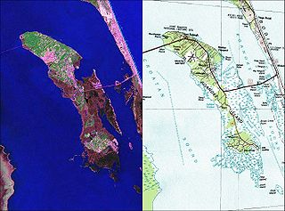
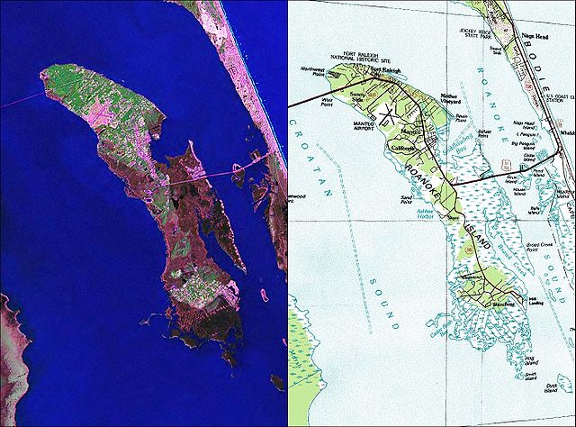
English: NASA World Wind Geocover 2000 and topographic map coverage of Roanoke Island, North Carolina |
| Dátum | 2000-es évek |
| Forrás | NASA World Wind Screen Shot |
| Szerző | NASA |
Licenc
This image is in the public domain in the United States because it only contains materials that originally came from the United States Geological Survey, an agency of the United States Department of the Interior. For more information, see the official USGS copyright policy.
|
Fájltörténet
Kattints egy időpontra, hogy a fájl akkori állapotát láthasd.
| Dátum/idő | Bélyegkép | Felbontás | Feltöltő | Megjegyzés | |
|---|---|---|---|---|---|
| aktuális | 2010. május 26., 14:35 | | 1 383 × 1 024 (1,26 MB) | Ratzer | {{Information |Description={{en|1=NASA World Wind Geocover 2000 and topographic map coverage of Roanoke Island, North Carolina}} |Source=NASA World Wind Screen Shot |Author=NASA |Date=2000s |Permission= |other_versions= }} [[Category:Maps of North Caroli |
Fájlhasználat
Az alábbi lap használja ezt a fájlt:
Globális fájlhasználat
A következő wikik használják ezt a fájlt:
- Használata itt: ca.wikipedia.org
- Használata itt: ceb.wikipedia.org
- Használata itt: de.wikipedia.org
- Használata itt: en.wikipedia.org
- Használata itt: eo.wikipedia.org
- Használata itt: es.wikipedia.org
- Használata itt: ja.wikipedia.org
- Használata itt: ko.wikipedia.org
- Használata itt: nl.wikipedia.org
- Használata itt: pl.wikipedia.org
- Használata itt: pt.wikipedia.org
- Használata itt: ru.wikipedia.org
- Használata itt: www.wikidata.org
- Használata itt: zh.wikipedia.org