Fájl:The Years of Rice and Salt (Pre-War Map).png

Az előnézet mérete: 800 × 407 képpont További felbontások: 320 × 163 képpont | 640 × 325 képpont | 1 024 × 521 képpont | 1 280 × 651 képpont | 2 753 × 1 400 képpont.
Eredeti fájl (2 753 × 1 400 képpont, fájlméret: 118 KB, MIME-típus: image/png)
|
Ez a fájl a Wikimedia Commonsból származik. Az alább látható leírás az ottani dokumentációjának másolata. A Commons projekt szabad licencű kép- és multimédiatár. Segíts te is az építésében! |
.png)
Összefoglaló
| Leírás |
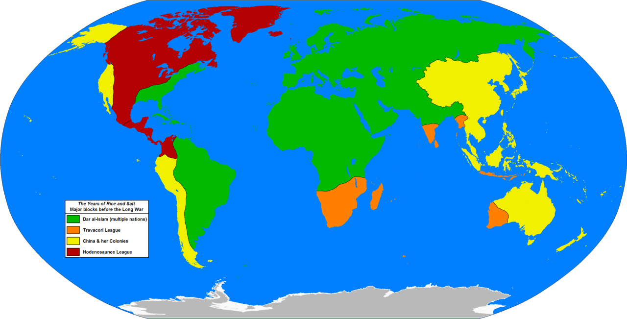
English: A map of the world of the alternate history book "The Years of Rice and Salt", by Kim Stanley Robinson. This map is based on one from the book (which is credited to Jeffrey L. Ward), it shows the four main blocs or alliances on the eve of the "Long War" (specific date is 1333 AH or 1915 AD).
This is not an exact copy of the map in the book, which is very different; being a hand drawn map which uses an unusual map projection. The borders are correct to the book, however some areas are not shown properly on the book's map and so I have had to interpolate a bit (i.e. the book's map does not show the Caribbean islands at all, so I have just chosen to assign them to Dar al-Islam as this seems the most logical based on the history contained in the novel). |
| Dátum | |
| Forrás | A feltöltő saját munkája |
| Szerző | Hibernian |
Licenc
Én, e mű szerzője a művemet az alábbi licenc alatt teszem közzé:
| Ez a fájl a Creative Commons CC0 1.0 Universal Public Domain Dedication licenc alatt lett közzétéve. | |
| A műhöz tartozó személy ezzel a dokumentummal a munkáját köztulajdonná tette. A törvények alapján megengedhető mértékig lemondott minden őt megillető jogról a szerzői jog és az összes kapcsolódó vagy vonatkozó törvény alapján, ami a munka alapján neki járna az egész világon. A CC0 alatt kiadott művek szerzőjét nem kell megjelölni. A munka hivatkozásakor nem kell jóváhagyást kérni a szerzőtől.
|
Fájltörténet
Kattints egy időpontra, hogy a fájl akkori állapotát láthasd.
| Dátum/idő | Bélyegkép | Felbontás | Feltöltő | Megjegyzés | |
|---|---|---|---|---|---|
| aktuális | 2014. november 18., 00:02 | | 2 753 × 1 400 (118 KB) | Hibernian | Minor corrections, the borders on Hispaniola and Timor were in the colour of the sea, when they should have been filled in with the colour of the political entity. |
| 2013. december 10., 02:07 |  | 2 753 × 1 400 (118 KB) | Hibernian | minor fix | |
| 2013. december 9., 23:40 |  | 2 753 × 1 400 (118 KB) | Hibernian | User created page with UploadWizard |
Fájlhasználat
Az alábbi lap használja ezt a fájlt:
Globális fájlhasználat
A következő wikik használják ezt a fájlt:
- Használata itt: en.wikipedia.org
- Használata itt: uk.wikipedia.org
.png)