Fájl:Theoreticaltownshipmap.gif
Az előnézet mérete: 554 × 600 képpont További felbontások: 222 × 240 képpont | 444 × 480 képpont | 694 × 751 képpont.
Eredeti fájl (694 × 751 képpont, fájlméret: 70 KB, MIME-típus: image/gif)
|
Ez a fájl a Wikimedia Commonsból származik. Az alább látható leírás az ottani dokumentációjának másolata. A Commons projekt szabad licencű kép- és multimédiatár. Segíts te is az építésében! |
Összefoglaló
| Leírás |
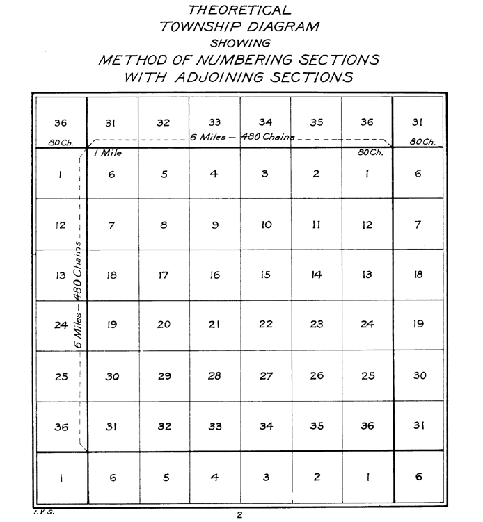
English: The image depicts a standard survey township with its 36 sections and the correponding sections from the surrounding survey townships. |
|||
| Dátum | ||||
| Forrás | The image was tansferred from the en.wiki. If necessary, it could be found here. | |||
| Szerző |
The image was done by the US Interior Bureau of Land Management
|
Licenc
Ez a kép az az amerikai szövetségi kormány alkalmazottjának munkája, így a US Code 17. rész, 1 fejezetének, 105-ös szekciója alapján közkincsnek minősül . Lásd még: Szerzői jogok.
Megjegyzés: Ez kizárólag a szövetségi kormány képeire vonatkozik, nem pedig az egyes szövetségi államok, megyék, városok, vagy más közigazgatási egységek alkalmazottai által készített képekre.
|
 | |
| Megállapították, hogy ez a fájl mentes mindenféle szerzői jogi korlátozástól, beleértve az összes kapcsolódó és hozzátartozó jogot. | ||
| This image is a work of a Bureau of Land Management* employee, taken or made as part of that person's official duties. As a work of the U.S. federal government, the image is in the public domain in the United States. *or predecessor organization |
Fájltörténet
Kattints egy időpontra, hogy a fájl akkori állapotát láthasd.
| Dátum/idő | Bélyegkép | Felbontás | Feltöltő | Megjegyzés | |
|---|---|---|---|---|---|
| aktuális | 2011. december 22., 23:25 | | 694 × 751 (70 KB) | Wars |
Fájlhasználat
Az alábbi lap használja ezt a fájlt:
Globális fájlhasználat
A következő wikik használják ezt a fájlt:
- Használata itt: ca.wikipedia.org
- Használata itt: en.wikipedia.org
- Használata itt: fr.wikipedia.org
- Használata itt: it.wikipedia.org
- Használata itt: ro.wikipedia.org