Fájl:1691 Sanson Map of the World on Hemisphere Projection - Geographicus - World2-sanson-1691.jpg
Az előnézet mérete: 800 × 490 képpont További felbontások: 320 × 196 képpont | 640 × 392 képpont | 1 024 × 627 képpont | 1 280 × 784 képpont | 2 560 × 1 567 képpont | 6 000 × 3 673 képpont.
Eredeti fájl (6 000 × 3 673 képpont, fájlméret: 6,16 MB, MIME-típus: image/jpeg)
|
Ez a fájl a Wikimedia Commonsból származik. Az alább látható leírás az ottani dokumentációjának másolata. A Commons projekt szabad licencű kép- és multimédiatár. Segíts te is az építésében! |
| Művész | ||||||
| Mű címe |
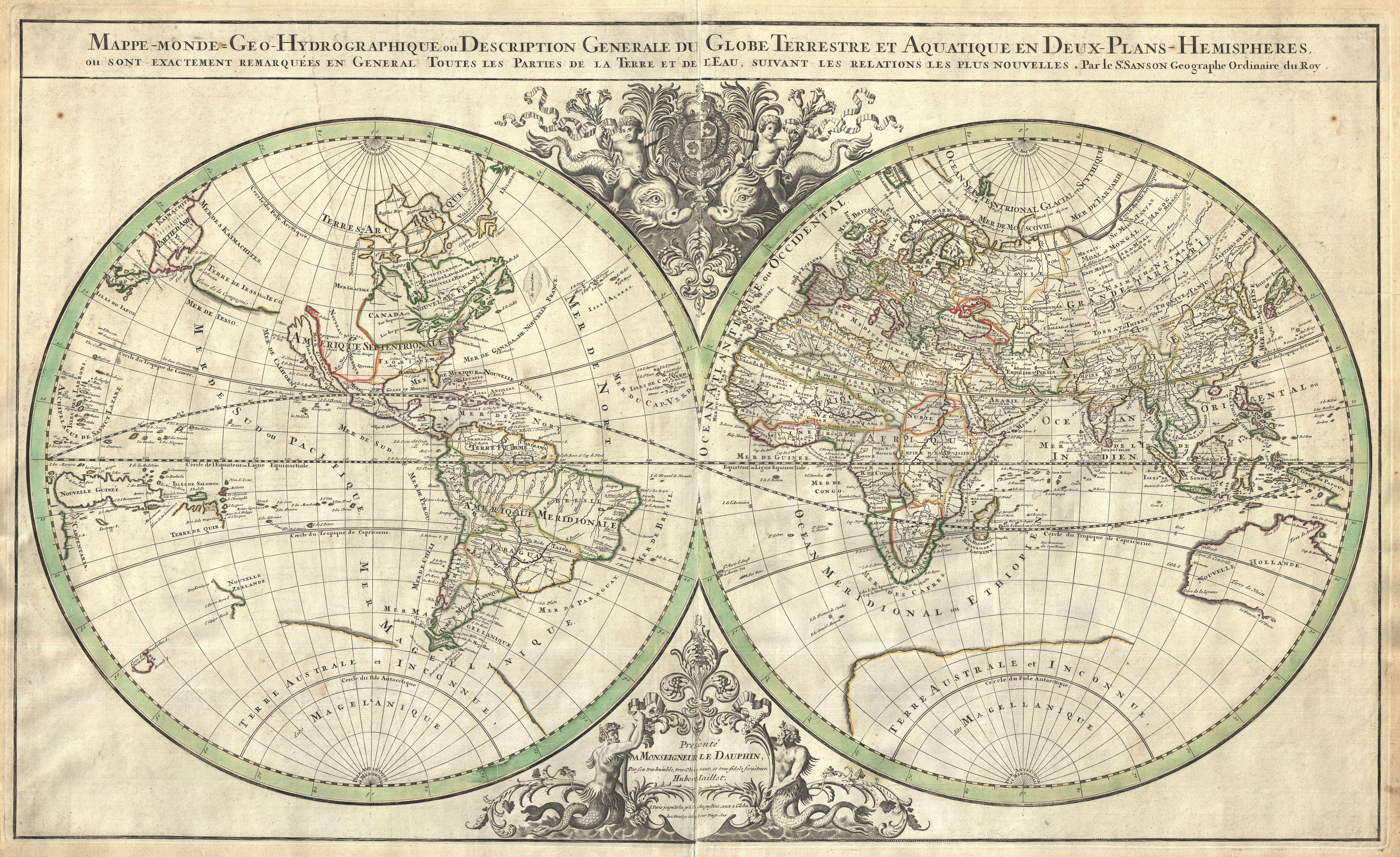
Mappe-monde Geo-Hydrographique ou Description Generale du Globe Terrestre et Aquatique en Deux-Plans-Hemipsheres ou son Exactement Remarquees en General Toutes les Parties de la Terre et de L'Eau, suivant les Relations les plus Nouvelles, par le S. Sanson Geographe Ordinaire du Roy. |
|||||
| Leírás |
English: An extraordinary map of monumental proportions, this Sanson and Jaillot's c.1691 decorative map of the world on a double hemisphere projection. Covers the entire world according to its 17th century conception. Elaborate allegorical cartouches appear at top center and bottom center detailing cherubs riding dolphins - the symbols of the Dauphin of France. Our survey of this map will begin in North America where California is depicted as an island. The idea of an insular California first appeared as a work of fiction in Garci Rodriguez de Montalvo's c. 1510 romance Las Sergas de Esplandian , where he writes Know, that on the right hand of the Indies there is an island called California very close to the side of the Terrestrial Paradise; and it is peopled by black women, without any man among them, for they live in the manner of Amazons. Baja California was subsequently discovered in 1533 by Fortun Ximenez, who had been sent to the area by Hernan Cortez. When Cortez himself traveled to Baja, he must have had Montalvo's novel in mind, for he immediately claimed the Island of California for the King. By the late 16th and early 17th century ample evidence had been amassed, through explorations of the region by Francisco de Ulloa, Hernando de Alarcon and others, that California was in fact a peninsula. However, by this time other factors were in play. Francis Drake had sailed north and claimed New Albion near modern day Washington or Vancouver for England. The Spanish thus needed to promote Cortez's claim on the Island of California to preempt English claims on the western coast of North America. The significant influence of the Spanish crown on European cartographers caused a major resurgence of the Insular California theory, of which Sanson was a primary proponent. Shortly after this map was made Eusebio Kino, a Jesuit missionary, traveled overland from Mexico to California, proving conclusively the peninsularity of California. Traveling northwest, away from the mainland, we come across a land labeled Terre de Jesso or Je Co. or Terre de la Compagnie. Though Yesso or Jesso is a name usually associated with Hokkaido (which here is drawn as part of mainland Asia), this land mass is more commonly called Gama or Gamaland. Gama was supposedly discovered in the 17th century by a mysterious figure known as Jean de Gama. Various subsequent navigators claim to have seen this land and it appeared in numerous maps well into the late 18th century. At times it was associated with Hokkaido, in Japan, and at other times with the mainland of North America. On this map we are struck by its uncanny resemblance to Gerhard Muller's peninsula which emerged in the late 18th century. Based on numerous sightings but no significant exploration of the Aleutian Islands, Muller postulated that the archipelago was in fact a single land mass. This he mapped extending from the North American mainland towards Asia much as the Terre de Compagnie does on this map. It is not inconceivable that navigators sailing in the northern seas from Asia could have made this same error in the 16th and 17th centuries. Moving east of California into the North American mainland we find ourselves in the Spanish colony of New Mexico. Santa Fe, its capital, had been founded in 1610 and here we find it situated far to the north of its actual location, on the Colorado (Rio Norte) rather than the Rio Grande or Santa Fe River. It also appears near a gigantic and mysterious lake named Apache. The Apache Lake is drawn as the source of the Rio Norte or Colorado River. Though the origins of this lake are somewhat mysterious, they may be associated with Native American reports of the Great Salt Lake or another lake in the region brought back by the Onate and Coronado expeditions. In the eastern part of New Mexico territory we come across the land of Quivira. |
|||||
| Dátum | 1691 (undated) | |||||
| Méretei | magasság: 22 hüvelyk (55,8 cm); szélesség: 35,5 hüvelyk (90,1 cm) | |||||
| Leltári szám |
Geographicus link: World2-sanson-1691 |
|||||
| Forrás/fényképész |
Jaillot, H., Atlas Nouveau, 1691 edition.
|
|||||
| Engedély (Fájl újrafelhasználása) |
|
|||||
| Más változatok | ||||||
.jpg)
Fájltörténet
Kattints egy időpontra, hogy a fájl akkori állapotát láthasd.
| Dátum/idő | Bélyegkép | Felbontás | Feltöltő | Megjegyzés | |
|---|---|---|---|---|---|
| aktuális | 2011. március 24., 20:42 | | 6 000 × 3 673 (6,16 MB) | BotMultichillT | {{subst:User:Multichill/Geographicus |link=http://www.geographicus.com/P/AntiqueMap/World2-sanson-1691 |product_name=1691 Sanson Map of the World on Hemisphere Projection |map_title=Mappe-monde Geo-Hydrographique ou Description Generale du Globe Terrestre |
Fájlhasználat
Az alábbi lap használja ezt a fájlt:
Globális fájlhasználat
A következő wikik használják ezt a fájlt:
- Használata itt: de.wikipedia.org
- Használata itt: lt.wikipedia.org
- Használata itt: pl.wikipedia.org