Fájl:Acer macrophyllum range map.png

Az előnézet mérete: 364 × 600 képpont További felbontások: 145 × 240 képpont | 291 × 480 képpont | 1 003 × 1 653 képpont.
Eredeti fájl (1 003 × 1 653 képpont, fájlméret: 201 KB, MIME-típus: image/png)
|
Ez a fájl a Wikimedia Commonsból származik. Az alább látható leírás az ottani dokumentációjának másolata. A Commons projekt szabad licencű kép- és multimédiatár. Segíts te is az építésében! |
Összefoglaló
| Leírás |
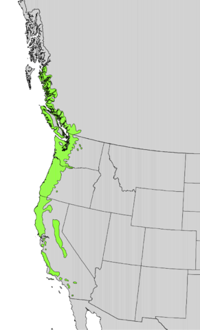
English: Range distribution map of Acer macrophyllum — on the West Coast of North America. |
|||
| Dátum | ||||
| Forrás | Digital representation of "Atlas of United States Trees" by Elbert L. Little, Jr. [1] | |||
| Szerző | U.S. Geological Survey | |||
| Engedély (Fájl újrafelhasználása) |
|
Fájltörténet
Kattints egy időpontra, hogy a fájl akkori állapotát láthasd.
| Dátum/idő | Bélyegkép | Felbontás | Feltöltő | Megjegyzés | |
|---|---|---|---|---|---|
| aktuális | 2012. október 12., 20:22 | | 1 003 × 1 653 (201 KB) | Pinethicket | {{Information |Description ={{en|1=Range map of ''Acer macrophyllum'' }} |Source =Digital representation of "Atlas of United States Trees" by Elbert L. Little, Jr. [http://esp.cr.usgs.gov/data/atlas/little/] |Author =U.S. Geological ... |
Fájlhasználat
Az alábbi lap használja ezt a fájlt:
Globális fájlhasználat
A következő wikik használják ezt a fájlt:
- Használata itt: ar.wikipedia.org
- Használata itt: arz.wikipedia.org
- Használata itt: eu.wikipedia.org
- Használata itt: fa.wikipedia.org
- Használata itt: pt.wikipedia.org
- Használata itt: www.wikidata.org