Eredeti fájl(1 545 × 1 242 képpont, fájlméret: 187 KB, MIME-típus: image/gif, ismétlődik, 14 képkocka, 44 s)

This image could be re-created using vector graphics as an SVG file. This has several advantages; see Commons:Media for cleanup for more information. If an SVG form of this image is available, please upload it and afterwards replace this template with {{vector version available|new image name}}. It is recommended to name the SVG file "Breakup of Yugoslavia.svg" - then the template Vector version available (or Vva) does not need the new image name parameter.

Összefoglaló

Key:

Yugoslavia (1943–1992) SFR Yugoslavia
Croatia (1991–present) Croatia
Herzeg-Bosnia (1992–1994)
UNTAES (1996–1998)
Federal Republic of Yugoslavia / Serbia and Montenegro (1992–2006) Serbia and Montenegro
Republika Srpska (1992–present) Republika Srpska
Serbian Krajina (1991–1995/96)
Republic of Bosnia and Herzegovina (1992–1995)
Bosnia and Herzegovina (1998–present) Bosnia and Herzegovina
Western Bosnia (1993–1995)
Serbia (2006–present) Serbia
Kosovo (under UNMIK control 1999–present; declaration of independence 2008) Kosovo
Montenegro (2006–present) Montenegro
Macedonia (1991–present) Macedonia
Slovenia (1991–present) Slovenia


Leírás

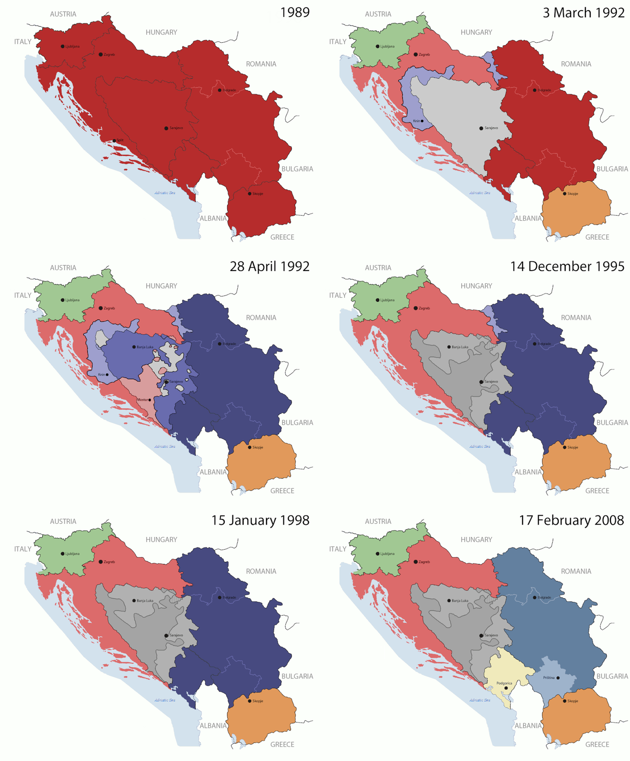
This is an animated GIF that shows the stages of the breakup of the SFR Yugoslavia in the 90's and 2000's. The map based off Morwen's map of the divisions of the SFRY, Which is licensed by the GFDL. The source for the dates of independence is the CIA World Factbook. These maps do not now show the Inter-Entity Boundary Line (IEBL) and/or the entities that are separated by it. The IEBL has been drawn based on this CIA map; the Brčko District has been drawn based on Image:BH municipality location.gif, by user:Ante Perkovic. I might add them in the future.

Since the original map was GFDL, this image is as well.

A map depicting Kosovo's final status is ready once it takes effect.


Changelog for versions 2/3:

Here are some changes in this new build of the map:

  • The Kosovo boundary has been given a shade of red instead of the previous UN blue since they are a province of Serbia under UNIMIK control.
  • Montenegro's color has been changed to a golden shade close to what's on the flag.
  • The IEBL and the Brčko District has been redrawn because I deleted the original map; the color for the Republika Srpska is lighter.
  • The dates are at the top left hand corner of the map instead of the bottom.
  • I have taken a new approach as to the boundaries. Each part of Yugoslavia now shows the boundary on the maps starting the year they broke away. I feel this change helps readers understand the breakup better.
  • The SFRY and the FRY are in different shades since the FRY was never accepted as the successor to the former by the UN.
  • The colors for the entities of BiH have been removed as to not confuse people into thinking that they are independent states. What remains is the IEBL with both entities in green.
  • The Kosovo boundary is finally in hash marks!
  • The Brčko District has been removed. The sale is too small to show accurately.

Changelog for version 4:

  • The map is larger!
  • The image has been rebuilt to include the eastern part of FYR Macedonia.
  • The image has been updated to take in Kosovo's new status.
  • The IEBL is now a darker line.
  • Montenegro, Kosovo, and FRY/SCG/Serbia have new colors!

Changelog for version 5:

  • Rebuilt
  • Larger map: size of base image
  • Accurate Inter-Entity Boundary Line
Dátum 24 July 2006 (orginal upload date)
Forrás Made by Hoshie; see above for more details on sources.
Szerző Hoshie
Más változatok

Licenc

GNU head Ez a fájl szabadon másolható, terjeszthető és/vagy módosítható a GNU Szabad Dokumentációs Licenc feltételei alapján, az 1.2 vagy későbbi, a Free Software Foundation által publikált Nem Változtatható szakaszok, Címlapszövegek és Hátlapszövegek nélküli változat szerint. E licenc egy példánya a GNU Szabad Dokumentációs Licenc című fejezetben olvasható.
w:hu:Creative Commons
Nevezd meg! Így add tovább!
Ez a fájl a Creative Commons Nevezd meg! – Így add tovább! 3.0 Unported licenc alapján használható fel.
A következőket teheted a művel:
  • megoszthatod – szabadon másolhatod, terjesztheted, bemutathatod és előadhatod a művet
  • feldolgozhatod – származékos műveket hozhatsz létre
Az alábbi feltételekkel:
  • Nevezd meg! – A szerzőt megfelelően fel kell tüntetned, hivatkozást kell létrehoznod a licencre és jelezned kell, ha a művön változtatást hajtottál végre. Ezt bármilyen észszerű módon megteheted, kivéve oly módon, ami azt sugallná hogy a jogosult támogat téged vagy a felhasználásod körülményeit.
  • Így add tovább! – Ha megváltoztatod, átalakítod, feldolgozod ezt a művet, a közreműködésedet csak az eredetivel megegyező vagy hasonló licenc alatt terjesztheted.
Ez a licenc a GFDL licenccsere során került a fájlra.

Képaláírások

Adj meg egy egysoros magyarázatot arról, hogy mit mutat be ez a fájl

A fájl által ábrázolt elemek

mű tárgya

05ca2aefea8406b809968643552d5095c847a42f

191 625 byte

44 másodperc

1 242 képpont

1 545 képpont

Fájltörténet

Kattints egy időpontra, hogy a fájl akkori állapotát láthasd.

(legutolsó | legelső) (10 újabb | ) (10 | 20 | 50 | 100 | 250 | 500)
Dátum/időBélyegképFelbontásFeltöltőMegjegyzés
aktuális2016. július 17., 09:40Bélyegkép a 2016. július 17., 09:40-kori változatról1 545 × 1 242 (187 KB)מפתח-רשימהReverted to version as of 17:22, 21 August 2015 (UTC)
2015. augusztus 21., 19:22Bélyegkép a 2015. augusztus 21., 19:22-kori változatról1 463 × 1 158 (1,81 MB)BraganzaReverted to version as of 03:57, 19 January 2010
2015. augusztus 21., 19:22Bélyegkép a 2015. augusztus 21., 19:22-kori változatról1 545 × 1 242 (187 KB)BraganzaReverted to version as of 01:02, 19 December 2011
2015. augusztus 21., 19:15Bélyegkép a 2015. augusztus 21., 19:15-kori változatról120 × 95 (3 KB)Braganza03:57, 19. Jan. 2010
2011. december 19., 03:02Bélyegkép a 2011. december 19., 03:02-kori változatról1 545 × 1 242 (187 KB)DIREKTORAdded details
2011. július 27., 20:09Bélyegkép a 2011. július 27., 20:09-kori változatról1 545 × 1 242 (170 KB)DIREKTORSmall fixes
2011. július 27., 19:28Bélyegkép a 2011. július 27., 19:28-kori változatról1 545 × 1 242 (171 KB)DIREKTORAdded UNMIK
2011. július 27., 18:38Bélyegkép a 2011. július 27., 18:38-kori változatról1 545 × 1 242 (165 KB)DIREKTORDates for the last two frames.
2011. július 27., 14:10Bélyegkép a 2011. július 27., 14:10-kori változatról1 545 × 1 242 (149 KB)DIREKTORLighter shade for country names
2011. július 26., 18:59Bélyegkép a 2011. július 26., 18:59-kori változatról1 545 × 1 242 (170 KB)DIREKTORHigher res plus details
(legutolsó | legelső) (10 újabb | ) (10 | 20 | 50 | 100 | 250 | 500)

Az alábbi lap használja ezt a fájlt:

Globális fájlhasználat

A következő wikik használják ezt a fájlt:

A fájl globális használatának megtekintése

Metaadatok