Fájl:California US Congressional District 25 (since 2013).tif

Ennek a(z) TIF fájlnak ezen PNG formátumú előnézete: 800 × 396 képpont. További felbontások: 320 × 158 képpont | 640 × 317 képpont | 1 024 × 507 képpont | 2 016 × 998 képpont.
Eredeti fájl (2 016 × 998 képpont, fájlméret: 2,69 MB, MIME-típus: image/tiff)
|
Ez a fájl a Wikimedia Commonsból származik. Az alább látható leírás az ottani dokumentációjának másolata. A Commons projekt szabad licencű kép- és multimédiatár. Segíts te is az építésében! |
Összefoglaló
| Leírás |
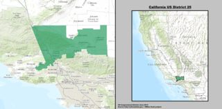
English: Map of the 25th Congressional District, representing part of northern Los Angeles County and part of eastern Ventura County, in Southern California.
Español: Mapa del 25.º Distrito Congresional de California— en Condados de Los Angeles y Ventura. |
| Dátum | |
| Forrás | GIS shapefile data created by the United States Department of the Interior, as part of the "1 Million Scale" geospatial data project. Retrieved from: http://nationalatlas.gov/atlasftp-1m.html?openChapters=#chpbound |
| Szerző | 1: GIS (congressional districts, 2013) shapefile data was created by the United States Department of the Interior. 2: Data was rendered using ArcGIS® software by Esri. 3: File developed for use on Wikipedia and elsewhere by 7partparadigm. |
Licenc
This map was obtained from an edition of the National Atlas of the United States. Like almost all works of the U.S. federal government, works from the National Atlas are in the public domain in the United States.
Online access: NationalAtlas.gov | 1970 print edition: Library of Congress, Perry-Castañeda Library
|
en:California's 25th congressional district es:25.º distrito congresional de California
Fájltörténet
Kattints egy időpontra, hogy a fájl akkori állapotát láthasd.
| Dátum/idő | Bélyegkép | Felbontás | Feltöltő | Megjegyzés | |
|---|---|---|---|---|---|
| aktuális | 2014. március 22., 05:18 |  | 2 016 × 998 (2,69 MB) | 7partparadigm | User created page with UploadWizard |
Fájlhasználat
Az alábbi lap használja ezt a fájlt:
Globális fájlhasználat
A következő wikik használják ezt a fájlt:
- Használata itt: en.wikipedia.org
- Használata itt: fr.wikipedia.org
- Használata itt: tr.wikipedia.org
- Használata itt: www.wikidata.org
- Használata itt: zh.wikipedia.org