Fájl:Camargue map.png
Nem érhető el nagyobb felbontású változat.
Camargue_map.png (718 × 396 képpont, fájlméret: 42 KB, MIME-típus: image/png)
|
Ez a fájl a Wikimedia Commonsból származik. Az alább látható leírás az ottani dokumentációjának másolata. A Commons projekt szabad licencű kép- és multimédiatár. Segíts te is az építésében! |
Összefoglaló
| Leírás | ||||
| Dátum | ||||
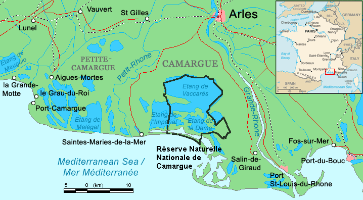
| Forrás | Combination of CIA World Factbook map (Image:Fr-map.png) and Demis Map Server (http://www2.demis.nl/mapserver/mapper.asp) data with additional annotations and modifications by self. | |||
| Szerző | ChrisO | |||
| Más változatok |
File:Camargue, Petite Caramgue et Parc naturel reg.png (relaunched and actualized)
|

Fájltörténet
Kattints egy időpontra, hogy a fájl akkori állapotát láthasd.
| Dátum/idő | Bélyegkép | Felbontás | Feltöltő | Megjegyzés | |
|---|---|---|---|---|---|
| aktuális | 2016. április 29., 23:34 | | 718 × 396 (42 KB) | Rsuessbr | Writing of Petite-Camargue corrected |
| 2015. augusztus 10., 19:15 |  | 718 × 396 (42 KB) | Rsuessrb | Added: limits of the natural park (according to a map published by snpn (Société Nationale de Protection de la Nature), 2015 | |
| 2012. március 20., 03:23 |  | 718 × 396 (38 KB) | Ras67 | cropped | |
| 2006. augusztus 16., 22:52 |  | 720 × 398 (41 KB) | ChrisO | Map of the Camargue region, southern France By ~~~, derived from open source mapping | |
| 2006. augusztus 16., 22:46 |  | 720 × 398 (40 KB) | ChrisO | Map of the Camargue region, southern France By ~~~, derived from open source mapping |
Fájlhasználat
Az alábbi lapok használják ezt a fájlt:
Globális fájlhasználat
A következő wikik használják ezt a fájlt:
- Használata itt: af.wikipedia.org
- Használata itt: ar.wikipedia.org
- Használata itt: az.wikipedia.org
- Használata itt: br.wikipedia.org
- Használata itt: ca.wikipedia.org
- Használata itt: co.wikipedia.org
- Használata itt: cs.wikipedia.org
- Használata itt: cy.wikipedia.org
- Használata itt: de.wikipedia.org
- Használata itt: en.wikipedia.org
- Használata itt: eo.wikipedia.org
- Használata itt: es.wikipedia.org
- Használata itt: fi.wikipedia.org
- Használata itt: fr.wikipedia.org
- Használata itt: gl.wikipedia.org
- Használata itt: id.wikipedia.org
- Használata itt: it.wikipedia.org
- Használata itt: ja.wikipedia.org
- Használata itt: ko.wikipedia.org
- Használata itt: lt.wikipedia.org
- Használata itt: mt.wikipedia.org
- Használata itt: nl.wikipedia.org
- Használata itt: nn.wikipedia.org
- Használata itt: no.wikipedia.org
- Használata itt: oc.wikipedia.org
- Használata itt: pl.wiktionary.org
A fájl globális használatának megtekintése