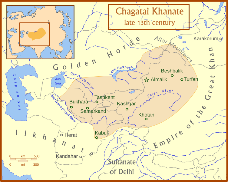
Fájl:Chagatai Khanate map en.svg

Ennek a(z) SVG fájlnak ezen PNG formátumú előnézete: 753 × 600 képpont. További felbontások: 301 × 240 képpont | 603 × 480 képpont | 964 × 768 képpont | 1 280 × 1 020 képpont | 2 560 × 2 039 képpont | 811 × 646 képpont.
Eredeti fájl (SVG fájl, névlegesen 811 × 646 képpont, fájlméret: 468 KB)
Fájltörténet
Kattints egy időpontra, hogy a fájl akkori állapotát láthasd.
| Dátum/idő | Bélyegkép | Felbontás | Feltöltő | Megjegyzés | |
|---|---|---|---|---|---|
| aktuális | 2008. július 15., 06:50 |  | 811 × 646 (468 KB) | MapMaster | +river name, + colour adjustment |
| 2008. július 15., 06:13 |  | 811 × 646 (454 KB) | MapMaster | made a few corrections to version | |
| 2008. július 15., 06:07 |  | 811 × 646 (426 KB) | MapMaster | {{Information |Description={{en|1=A map of the Chagatai Khanate, late 13th century}} |Source=Own work by uploader |Author=MapMaster |Date=14 July 2008 |Permission= |other_versions= }} {{ImageUpload|full}} |
Fájlhasználat
Az alábbi lapok használják ezt a fájlt:
Globális fájlhasználat
A következő wikik használják ezt a fájlt:
- Használata itt: azb.wikipedia.org
- Használata itt: az.wikipedia.org
- Használata itt: bg.wikipedia.org
- Használata itt: bn.wikipedia.org
- Használata itt: ca.wikipedia.org
- Használata itt: ce.wikipedia.org
- Használata itt: crh.wikipedia.org
- Használata itt: da.wikipedia.org
- Használata itt: de.wikipedia.org
- Használata itt: el.wikipedia.org
- Használata itt: en.wikipedia.org
- Használata itt: eo.wikipedia.org
- Használata itt: et.wikipedia.org
- Használata itt: fr.wikipedia.org
- Használata itt: he.wikipedia.org
- Használata itt: hi.wikipedia.org
- Használata itt: hr.wikipedia.org
- Használata itt: it.wikipedia.org
- Használata itt: ja.wikipedia.org
- Használata itt: kk.wikipedia.org
- Használata itt: ko.wikipedia.org
- Használata itt: lt.wikipedia.org
- Használata itt: mk.wikipedia.org
- Használata itt: mn.wikipedia.org
- Használata itt: nl.wikipedia.org
- Használata itt: oc.wikipedia.org
- Használata itt: pl.wikipedia.org
- Használata itt: pnb.wikipedia.org
- Használata itt: ru.wikipedia.org
A fájl globális használatának megtekintése