Fájl:Climatic zones and antipodes.png
Climatic_zones_and_antipodes.png (180 × 180 képpont, fájlméret: 31 KB, MIME-típus: image/png)
|
Ez a fájl a Wikimedia Commonsból származik. Az alább látható leírás az ottani dokumentációjának másolata. A Commons projekt szabad licencű kép- és multimédiatár. Segíts te is az építésében! |
Összefoglaló
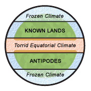
Diagram illustrating the classical climatic zones. The torrid (and "unhabitable") climatic zone of the equator is in red, the cold (and "unhabitable") climatic zones at the poles are in white/blue.
"Dating back to classical times, most people thought of the world as divided into zones of climate: a frozen climate at the poles, a torrid climate at the equator, and a blissfully mild (and therefore habitable) climate in between. They logically connected the temperature difference of these zones with proximity to the sun, and to a large extent they were right. Where they were wrong, however, was in their belief that the cold and torrid zones were impassable." [1] archivált másolat at the Wayback Machine
This image was made by Leinad-Z. Based on Image:Mappaemundi vertical.gif by John Hamer and inspired by images from Macrobius' Commentarii in Somnium Scipionis. More specifically, the picture is related with the two diagrams below.
-
 The five climatic zones of the earth.
 -
 Figure of the Earth from Macrobius.


Licenc
- A következőket teheted a művel:
- megoszthatod – szabadon másolhatod, terjesztheted, bemutathatod és előadhatod a művet
- feldolgozhatod – származékos műveket hozhatsz létre
- Az alábbi feltételekkel:
- Nevezd meg! – A szerzőt megfelelően fel kell tüntetned, hivatkozást kell létrehoznod a licencre és jelezned kell, ha a művön változtatást hajtottál végre. Ezt bármilyen észszerű módon megteheted, kivéve oly módon, ami azt sugallná hogy a jogosult támogat téged vagy a felhasználásod körülményeit.

|
Ezt a képet el kellene készíteni vektorgrafika használatával SVG fájlként. A formátumnak számos előnye van; lásd a Commons:Media for cleanup lapot a további információkért. Ha a képnek már elérhető SVG-formátumú változata, töltsd fel. Az SVG feltöltése után cseréld le ezt a sablont a következőre: {{vector version available|új kép neve.svg}}.
|
Fájltörténet
Kattints egy időpontra, hogy a fájl akkori állapotát láthasd.
| Dátum/idő | Bélyegkép | Felbontás | Feltöltő | Megjegyzés | |
|---|---|---|---|---|---|
| aktuális | 2006. augusztus 18., 23:25 | | 180 × 180 (31 KB) | Leinad-Z~commonswiki | "Texturized" version. |
| 2006. augusztus 18., 23:23 |  | 180 × 180 (12 KB) | Leinad-Z~commonswiki | New colors and text position. | |
| 2006. augusztus 17., 21:44 |  | 180 × 180 (12 KB) | Leinad-Z~commonswiki | Made by by Leinad-Z. Based on Image:Mappaemundi vertical.gif by John Hamer. |
Fájlhasználat
Az alábbi lap használja ezt a fájlt:
Globális fájlhasználat
A következő wikik használják ezt a fájlt:
- Használata itt: ar.wikipedia.org
- Használata itt: en.wikipedia.org
- Használata itt: es.wikipedia.org
- Használata itt: no.wikipedia.org