Fájl:Heteralocha acutirostris distribution.png
Az előnézet mérete: 451 × 600 képpont További felbontások: 180 × 240 képpont | 361 × 480 képpont | 577 × 768 képpont | 1 070 × 1 423 képpont.
Eredeti fájl (1 070 × 1 423 képpont, fájlméret: 135 KB, MIME-típus: image/png)
|
Ez a fájl a Wikimedia Commonsból származik. Az alább látható leírás az ottani dokumentációjának másolata. A Commons projekt szabad licencű kép- és multimédiatár. Segíts te is az építésében! |
Összefoglaló
| Leírás |
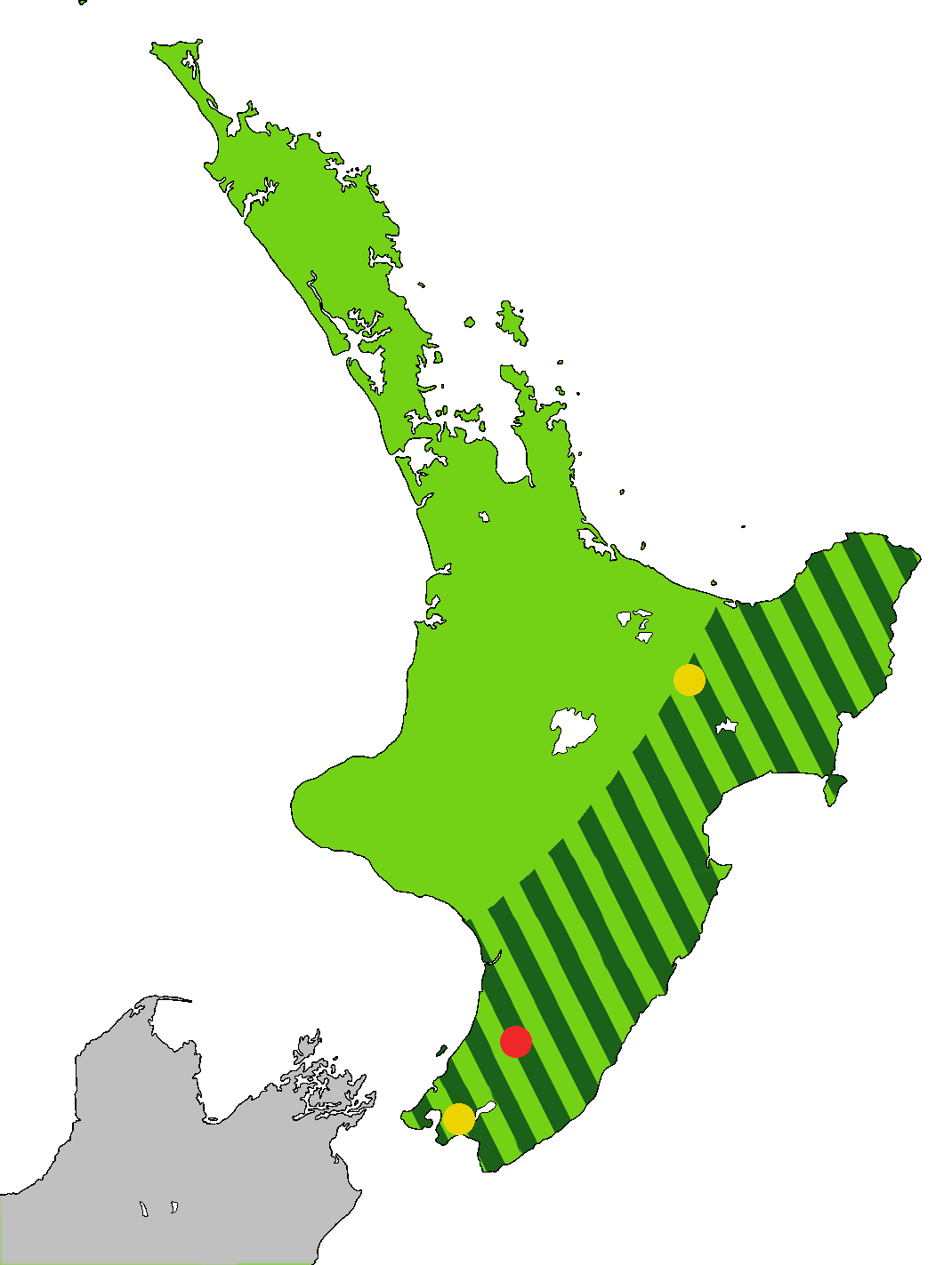
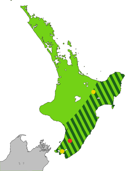
English: Light green: Range of the Huia, Heteralocha acutirostris, before the arrival of humans to New Zealand, as indicated by fossils. Dark green stripes: Range at 1840. Last sightings of the Huia: Red - last confirmed sighting in 1907 in Tararua Range. Yellow x 2 include one behind Eastbourne at the southern end of the North Island, and one in the Te Urewera National Park. The Huia is an extinct bird that was endemic to the North Island of New Zealand
Čeština: Laločník ostrozobý – distribuce. Světle zeleně: původní rozšíření laločníka ostrozobého; tmavě zelenými pruhy: rozsah druhu kolem roku 1840; červený bod: poslední potvrzené pozorování; žlutý bod: neověřená pozorování |
| Dátum | |
| Forrás | A feltöltő saját munkája. Based on first version by Casliber with information provided by User:Kotare, using as a base for the outline File:New Zealand location map transparent.svg adapted by uploader User:Kahuroa |
| Szerző | Kahuroa |
Licenc
| Kahuroa, a mű szerzője művét közkinccsé nyilvánította. Ez a világ minden részén érvényes. Egyes országokban ez jogilag nem lehetséges. Ha így van, akkor: |
Fájltörténet
Kattints egy időpontra, hogy a fájl akkori állapotát láthasd.
| Dátum/idő | Bélyegkép | Felbontás | Feltöltő | Megjegyzés | |
|---|---|---|---|---|---|
| aktuális | 2010. szeptember 14., 20:36 | | 1 070 × 1 423 (135 KB) | Kahuroa | Use new outline source: File:New Zealand location map transparent.svg adapted by uploader User:Kahuroa |
| 2010. augusztus 31., 09:31 |  | 1 760 × 2 346 (220 KB) | Kahuroa | New map - uses stripes to denote range in 1840 | |
| 2010. július 21., 23:46 |  | 449 × 599 (49 KB) | Casliber | {{Information |Description= |Source={{own}} |Date= |Author= Casliber |Permission= |other_versions= }} | |
| 2010. július 21., 23:04 |  | 449 × 599 (49 KB) | Casliber | {{Information |Description= Map added last sitings of the Huia. Red - last confirmed siting in 1907 in Tararua Range. Yellow x 2 include one behind Eastbourne, and one in the Te Urewera National Park. |Source={{own}} |Date= 23rd July 2010 |Author= [[User: | |
| 2010. július 21., 22:52 |  | 449 × 599 (48 KB) | Casliber | {{Information |Description={{en|1=Map of deforestation of North Island on New Zealand}} |Source={{own}} |Author=Casliber |Date=22nd July 2010 |Permission=yes |other_versions=no }} Category:Maps |
Fájlhasználat
Az alábbi lap használja ezt a fájlt:
Globális fájlhasználat
A következő wikik használják ezt a fájlt:
- Használata itt: ar.wikipedia.org
- Használata itt: bn.wikipedia.org
- Használata itt: ca.wikipedia.org
- Használata itt: ceb.wikipedia.org
- Használata itt: cs.wikipedia.org
- Használata itt: en.wikipedia.org
- Használata itt: es.wikipedia.org
- Használata itt: eu.wikipedia.org
- Használata itt: fa.wikipedia.org
- Használata itt: gl.wikipedia.org
- Használata itt: he.wikipedia.org
- Használata itt: it.wikipedia.org
- Használata itt: nn.wikipedia.org
- Használata itt: pl.wikipedia.org
- Használata itt: pt.wikipedia.org
- Használata itt: ru.wikipedia.org
- Használata itt: sr.wikipedia.org
- Használata itt: sv.wikipedia.org
- Használata itt: ta.wikipedia.org
- Használata itt: uk.wikipedia.org
- Használata itt: vi.wikipedia.org
- Használata itt: www.wikidata.org
- Használata itt: zh.wikipedia.org