Fájl:Island of Ireland location map Donegal.svg

Ennek a(z) SVG fájlnak ezen PNG formátumú előnézete: 481 × 599 képpont. További felbontások: 192 × 240 képpont | 385 × 480 képpont | 616 × 768 képpont | 822 × 1 024 képpont | 1 643 × 2 048 képpont | 1 450 × 1 807 képpont.
Eredeti fájl (SVG fájl, névlegesen 1 450 × 1 807 képpont, fájlméret: 642 KB)
|
Ez a fájl a Wikimedia Commonsból származik. Az alább látható leírás az ottani dokumentációjának másolata. A Commons projekt szabad licencű kép- és multimédiatár. Segíts te is az építésében! |
| Leírás |
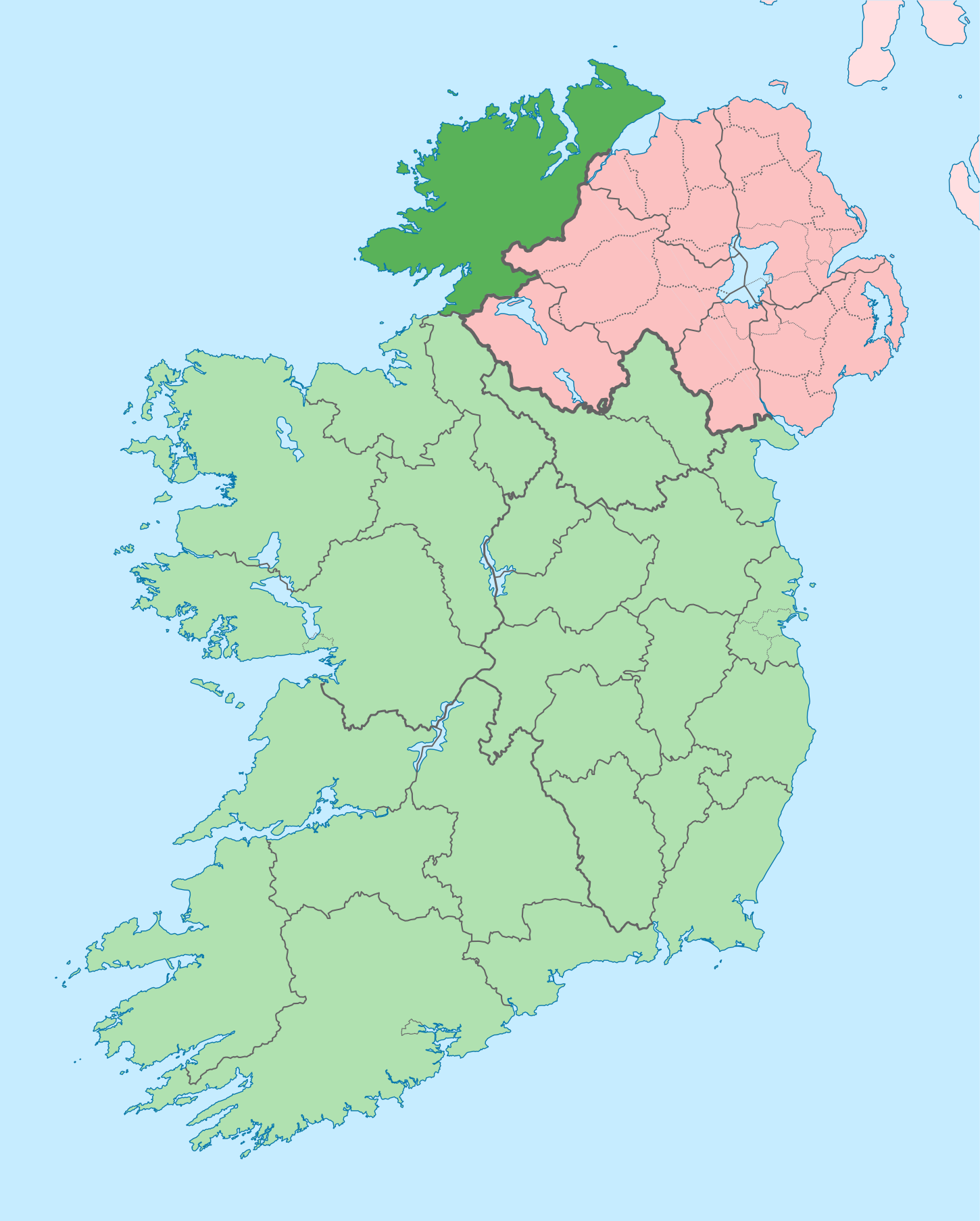
English: The island of Ireland, showing international border between Ireland and Northern Ireland, traditional provinces, traditional counties, and local authority areas in Ireland and Northern Ireland. |
| Dátum | (UTC) |
| Forrás | |
| Szerző |
|
| Ez egy retusált kép, ami azt jelenti, hogy az eredetihez képest digitálisan módosították. Módosítások: Coloured in regions with county of article highlighted. Az eredeti itt található: Island of Ireland location map.svg. Módosította: Mabuska.
|
Én, e mű szerzője a művemet az alábbi licenc alatt teszem közzé:
Ez a fájl a Creative Commons Nevezd meg! – Így add tovább! 3.0 Unported licenc alapján használható fel.
- A következőket teheted a művel:
- megoszthatod – szabadon másolhatod, terjesztheted, bemutathatod és előadhatod a művet
- feldolgozhatod – származékos műveket hozhatsz létre
- Az alábbi feltételekkel:
- Nevezd meg! – A szerzőt megfelelően fel kell tüntetned, hivatkozást kell létrehoznod a licencre és jelezned kell, ha a művön változtatást hajtottál végre. Ezt bármilyen észszerű módon megteheted, kivéve oly módon, ami azt sugallná hogy a jogosult támogat téged vagy a felhasználásod körülményeit.
- Így add tovább! – Ha megváltoztatod, átalakítod, feldolgozod ezt a művet, a közreműködésedet csak az eredetivel megegyező vagy hasonló licenc alatt terjesztheted.
Eredeti feltöltési napló
This image is a derivative work of the following images:
- File:Island_of_Ireland_location_map.svg licensed with Cc-by-sa-3.0
- 2010-03-06T20:43:33Z Rannpháirtí anaithnid 1450x1807 (679207 Bytes) Fix incorrectly coloured isands.
- 2010-03-03T22:19:29Z Rannpháirtí anaithnid 1450x1807 (679744 Bytes) {{Information |Description={{de|Positionskarte von [[:de:Irland|Irland]]}} Quadratische Plattkarte, N-S-Streckung 170 %. Geographische Begrenzung der Karte: * N: 55.6° N * S: 51.2° N * W: 11.0° W * O: 5.0° W {{en|Location
Uploaded with derivativeFX
Fájltörténet
Kattints egy időpontra, hogy a fájl akkori állapotát láthasd.
| Dátum/idő | Bélyegkép | Felbontás | Feltöltő | Megjegyzés | |
|---|---|---|---|---|---|
| aktuális | 2020. június 29., 15:41 | | 1 450 × 1 807 (642 KB) | Chipmunkdavis | Further edits per the Local Government Reform Act 2014, joining both Tipperarys and both Waterfords (and removing Limerick City code). Colouring in islands, cleaning up and grouping code to remove stray objects and show Galway and Lough Ree. |
| 2016. május 6., 05:49 |  | 1 450 × 1 807 (833 KB) | Houdinipeter | to reflect the changes of the w:Local Government Reform Act 2014 | |
| 2010. július 19., 02:43 |  | 1 450 × 1 807 (815 KB) | Mabuska | {{Information |Description={{en|The island of Ireland, showing international border between Northern Ireland and Republic of Ireland, traditional provinces, traditional counties, and local authority areas in the Republic of Ireland and Northern Ireland.}} |
Fájlhasználat
Az alábbi lap használja ezt a fájlt:
Globális fájlhasználat
A következő wikik használják ezt a fájlt:
- Használata itt: ar.wikipedia.org
- Használata itt: ast.wikipedia.org
- Használata itt: bg.wikipedia.org
- Használata itt: ca.wikipedia.org
- Comtat de Donegal
- Gaoth Dobhair
- Lifford
- Letterkenny
- Plantilla:Comtat Donegal
- Ballyshannon
- Buncrana
- Bundoran
- Ballybofey
- Carndonagh
- Donegal
- Na Rosa
- Cloch Cheann Fhaola
- Gort an Choirce
- An Fál Carrach
- Machaire Rabhartaigh
- Toraigh
- Baile na Finne
- Teileann
- Gleann Cholm Cille
- Carraig Airt
- Na Dúnaibh
- Cill Charthaigh
- Doirí Beaga
- Croithlí
- Oileán na Cruite
- Gabhla
- An Bun Beag
- Anagaire
- Ailt an Chorráin
- An Dúchoraidh
- Cionn Caslach
- Leitir Mhic an Bhaird
- Loch an Iúir
- Rann na Feirste
- An Clochán Liath
- Árainn Mhór
- Rathmullan
- Ramelton
- Milford (Donegal)
- Raphoe
- Inishowen
- Corredor de Donegal
- Killybegs
- Használata itt: ceb.wikipedia.org
- Használata itt: cs.wikipedia.org
- Használata itt: en.wikipedia.org
A fájl globális használatának megtekintése