Fájl:Jakarta Skyline Part 2.jpg

Eredeti fájl (1 546 × 768 képpont, fájlméret: 801 KB, MIME-típus: image/jpeg)
|
Ez a fájl a Wikimedia Commonsból származik. Az alább látható leírás az ottani dokumentációjának másolata. A Commons projekt szabad licencű kép- és multimédiatár. Segíts te is az építésében! |

|
Copyright warning: A subject in this image is protected by copyright.
This image features an architectural or artistic work, photographed from a public space in Indonesia. There are no freedom of panorama exceptions of any kind under the Chapter VI (Copyright Limitations), Articles 43–51 of the Indonesian Copyright Act No. 28, 2014, which means that these architectural or artistic works cannot be photographed freely for anything other than non-commercial or personal uses. If a copyrighted architectural or artistic work is contained in this image and it is a substantial reproduction, this photo cannot be licensed under a free license, and will be deleted. Framing this image to focus on the copyrighted work is also a copyright violation. Before reusing this content, ensure that you have the right to do so. You are solely responsible for ensuring that you do not infringe someone else's copyrights. See our general disclaimer for more information. |

Összefoglaló
| Leírás |
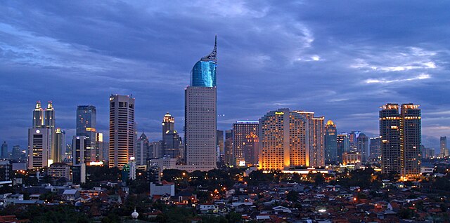
English: Lining up Jakarta's skyscrapers along the CBD with Wisma 46 as the centerpiece.
Wisma 46 is designed by Zeidler Partnership and has been well-known for being Indonesia's tallest building; and Jakarta's most distinguished skyscrapers with its unique shape resembling an elegant fountain pen. Singapore may have a "Durian" (The Esplanade); and Beijing has a "Bird's Nest" (Olympic Stadium) and "Trousers Pants" (CCTV Tower); but Jakarta has an elegant "Fountain Pen". Although it may not be the tallest building in Indonesia now, -with the completion of Menara BCA and The Kempinski Residences at the Grand Indonesia Mall complex; and construction at The Jakarta Tower (558m) is coming soon-, Wisma 46 remains one of the nation's most distinguished and unique building. |
| Dátum | |
| Forrás | https://www.flickr.com/photos/joe-joe/2303992129/ |
| Szerző | yohanes budiyanto |
| Objektum elhelyezkedése | | További képek erről a helyről: OpenStreetMap |
|---|
Licenc
- A következőket teheted a művel:
- megoszthatod – szabadon másolhatod, terjesztheted, bemutathatod és előadhatod a művet
- feldolgozhatod – származékos műveket hozhatsz létre
- Az alábbi feltételekkel:
- Nevezd meg! – A szerzőt megfelelően fel kell tüntetned, hivatkozást kell létrehoznod a licencre és jelezned kell, ha a művön változtatást hajtottál végre. Ezt bármilyen észszerű módon megteheted, kivéve oly módon, ami azt sugallná hogy a jogosult támogat téged vagy a felhasználásod körülményeit.
| This image was originally posted to Flickr by yohanes budiyanto at https://www.flickr.com/photos/27228523@N00/2303992129. It was reviewed on 2009. december 20. by FlickreviewR and was confirmed to be licensed under the terms of the cc-by-2.0. |
Fájltörténet
Kattints egy időpontra, hogy a fájl akkori állapotát láthasd.
| Dátum/idő | Bélyegkép | Felbontás | Feltöltő | Megjegyzés | |
|---|---|---|---|---|---|
| aktuális | 2023. május 3., 23:45 | | 1 546 × 768 (801 KB) | B18IDH | Maybe This Is More Correct? |
| 2009. december 19., 21:05 |  | 906 × 450 (519 KB) | Rochelimit | {{Information |Description={{en|1=Lining up Jakarta's skyscrapers. I took similar picture before with my Leica. This time, I tried it with my E-500 when the setting is blue, unlike previously in magenta. I'm also trying the 'golden rule' where the most pr |
Fájlhasználat
Az alábbi lapok használják ezt a fájlt:
Globális fájlhasználat
A következő wikik használják ezt a fájlt:
- Használata itt: ar.wikipedia.org
- Használata itt: arz.wikipedia.org
- Használata itt: ast.wikipedia.org
- Használata itt: azb.wikipedia.org
- Használata itt: ban.wikipedia.org
- Használata itt: ba.wikipedia.org
- Használata itt: bjn.wikipedia.org
- Használata itt: blk.wikipedia.org
- Használata itt: bn.wikipedia.org
- Használata itt: bn.wikibooks.org
- Használata itt: bs.wikipedia.org
- Használata itt: bug.wikipedia.org
- Használata itt: bxr.wikipedia.org
- Használata itt: ceb.wikipedia.org
- Használata itt: ckb.wikipedia.org
- Használata itt: crh.wikipedia.org
- Használata itt: csb.wikipedia.org
- Használata itt: cu.wikipedia.org
- Használata itt: cy.wikipedia.org
- Használata itt: dag.wikipedia.org
- Használata itt: de.wikipedia.org
- Használata itt: diq.wikipedia.org
- Használata itt: dv.wikipedia.org
- Használata itt: en.wikipedia.org
- Használata itt: en.wikivoyage.org
- Használata itt: eo.wikipedia.org
- Használata itt: es.wikipedia.org
- Használata itt: eu.wikipedia.org
- Használata itt: fa.wikipedia.org
A fájl globális használatának megtekintése