Fájl:Karte Aut Stmk BM (bis 2012).png
Nem érhető el nagyobb felbontású változat.
Karte_Aut_Stmk_BM_(bis_2012).png (300 × 209 képpont, fájlméret: 5 KB, MIME-típus: image/png)
|
Ez a fájl a Wikimedia Commonsból származik. Az alább látható leírás az ottani dokumentációjának másolata. A Commons projekt szabad licencű kép- és multimédiatár. Segíts te is az építésében! |
.png)
Összefoglaló
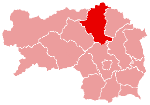
- English: Political map of the district Bruck an der Mur, Styria, Austria (until 2012)
- Deutsch: Politische Karte vom Bezirk Bruck an der Mur (bis 2012)
- drawing by de:User:plp from 2004
- Source: de.wikipedia.org: 22:37, 5. Apr 2004 . . Plp (Diskussion) . . 300 x 209 (3933 Byte)
Licenc

|
Ez a fájl szabadon másolható, terjeszthető és/vagy módosítható a GNU Szabad Dokumentációs Licenc feltételei alapján, az 1.2 vagy későbbi, a Free Software Foundation által publikált Nem Változtatható szakaszok, Címlapszövegek és Hátlapszövegek nélküli változat szerint. E licenc egy példánya a GNU Szabad Dokumentációs Licenc című fejezetben olvasható. |
| Ez a fájl a Creative Commons Nevezd meg! – Így add tovább! 3.0 Unported licenc alapján használható fel. | ||
| ||
| Ez a licenc a GFDL licenccsere során került a fájlra. |
Fájltörténet
Kattints egy időpontra, hogy a fájl akkori állapotát láthasd.
| Dátum/idő | Bélyegkép | Felbontás | Feltöltő | Megjegyzés | |
|---|---|---|---|---|---|
| aktuális | 2015. január 10., 14:22 | | 300 × 209 (5 KB) | Kontrollstellekundl | Reverted to version as of 13:29, 24 March 2012 |
| 2015. január 4., 20:58 |  | 1 000 × 700 (98 KB) | Kontrollstellekundl | Grenzen aller Bezirke ab 2015, Datei wird bei Imagemaps verwendet, deshalb für den "alten" Bezirk BM nicht mehr richtig! | |
| 2013. január 6., 22:41 |  | 300 × 209 (5 KB) | Kontrollstellekundl | Reverted to version as of 13:29, 24 March 2012 | |
| 2013. január 1., 19:54 |  | 300 × 209 (3 KB) | Gugganij | Merger of two districts to Bruck-Mürzzuschlag (BM) | |
| 2012. március 24., 15:29 |  | 300 × 209 (5 KB) | Kontrollstellekundl | JU + KF = MT, 01.01.2012 | |
| 2006. március 16., 03:42 |  | 300 × 209 (4 KB) | Inge-Lyubov~commonswiki | *{{en|Political map of the Bruck an der Mur District, Styria, Austria}} *{{de|Politische Karte von Bezirk Bruck an der Mur}} *drawing by de:User:plp from 2004 *Source: de.wikipedia.org: ''<now |
Fájlhasználat
Ezt a fájlt nem használja egyetlen lap sem.
Globális fájlhasználat
A következő wikik használják ezt a fájlt:
- Használata itt: cs.wikipedia.org
- Használata itt: es.wikipedia.org
- Használata itt: fa.wikipedia.org
- Használata itt: fr.wikipedia.org
- Használata itt: fur.wikipedia.org
- Használata itt: ja.wikipedia.org
- Használata itt: pl.wikipedia.org
- Használata itt: pnb.wikipedia.org
- Használata itt: ro.wikipedia.org
- Használata itt: ru.wikipedia.org
- Használata itt: sv.wikipedia.org
- Használata itt: uz.wikipedia.org
- Használata itt: www.wikidata.org
- Használata itt: zh.wikipedia.org
.png)