Fájl:King John's campaign 1215-6.png
Az előnézet mérete: 458 × 600 képpont További felbontások: 183 × 240 képpont | 366 × 480 képpont | 781 × 1 023 képpont.
Eredeti fájl (781 × 1 023 képpont, fájlméret: 165 KB, MIME-típus: image/png)
|
Ez a fájl a Wikimedia Commonsból származik. Az alább látható leírás az ottani dokumentációjának másolata. A Commons projekt szabad licencű kép- és multimédiatár. Segíts te is az építésében! |
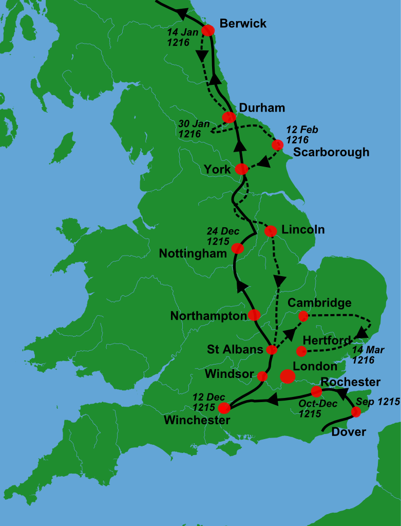
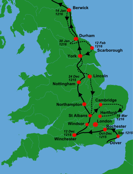
| Leírás | A blank locator map for Great Britain, with King John's 1216-6 military campaigns superimposed on it (using information from Warren, "King John", p. 250. The idea is to superimpose Image:dot4gb.svg at the appropriate point. See w:Template:GBthumb for code to do this. These two images can replace any locator map posted by Lupin - see w:Special:Contributions/LupinBot. This is a vectorized version of Image:Gb4dot.png, with the scale changed from 200 km to 150 km/150 miles. The shoreline data come from the file gshhs_h.b from the GSHHS, and the rivers and the Irish border come from the CIA World DataBank II; both sources are in the public domain. Mercator projection. == |
| Dátum | (UTC) |
| Forrás |
Own work using:
|
| Szerző |
|
| Ez egy retusált kép, ami azt jelenti, hogy az eredetihez képest digitálisan módosították. Módosítások: Trimmed, campaign superimposed. Az eredeti itt található: Gb4dot.svg. Módosította: Hchc2009.
|
Én, e mű szerzője a művemet az alábbi licenc alatt teszem közzé:
| Én, a szerző, ezt a művemet ezennel közkinccsé nyilvánítom. Ez a világ minden részén érvényes. Egyes országokban ez jogilag nem lehetséges. Ha így van, akkor: Jogot adok bárkinek, hogy bármilyen célból, feltétel nélkül használhassa ezt a fájlt, kivéve a törvény által kötelezően előírt feltételeket. |
Eredeti feltöltési napló
This image is a derivative work of the following images:
- File:Gb4dot.svg licensed with PD-self
Uploaded with derivativeFX
Fájltörténet
Kattints egy időpontra, hogy a fájl akkori állapotát láthasd.
| Dátum/idő | Bélyegkép | Felbontás | Feltöltő | Megjegyzés | |
|---|---|---|---|---|---|
| aktuális | 2011. január 2., 12:08 | | 781 × 1 023 (165 KB) | Hchc2009 | {{Information |Description=A blank locator map for Great Britain, with King John's 1216-6 military campaigns superimposed on it (using information from Warren, "King John", p.250. The idea is to superimpose Image:dot4gb.svg at the appropriate point. |
Fájlhasználat
Az alábbi lap használja ezt a fájlt:
Globális fájlhasználat
A következő wikik használják ezt a fájlt:
- Használata itt: az.wikipedia.org
- Használata itt: en.wikipedia.org
- Használata itt: fr.wikipedia.org
- Használata itt: gl.wikipedia.org
- Használata itt: nl.wikipedia.org
- Használata itt: ru.wikipedia.org
- Használata itt: tr.wikipedia.org
- Használata itt: zh.wikipedia.org