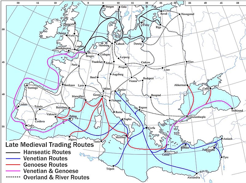
Fájl:Late Medieval Trade Routes.jpg

Az előnézet mérete: 800 × 597 képpont További felbontások: 320 × 239 képpont | 640 × 478 képpont | 1 024 × 765 képpont | 1 280 × 956 képpont | 1 457 × 1 088 képpont.
Eredeti fájl (1 457 × 1 088 képpont, fájlméret: 372 KB, MIME-típus: image/jpeg)
Fájltörténet
Kattints egy időpontra, hogy a fájl akkori állapotát láthasd.
| Dátum/idő | Bélyegkép | Felbontás | Feltöltő | Megjegyzés | |
|---|---|---|---|---|---|
| aktuális | 2022. május 18., 22:46 |  | 1 457 × 1 088 (372 KB) | Richard2s | Clearer key for map |
| 2011. január 23., 22:25 |  | 853 × 544 (453 KB) | Micsha~commonswiki | Includes map key on the map | |
| 2008. március 28., 17:55 |  | 1 817 × 1 120 (487 KB) | Lampman | {{Information |Description=Map showing the main trade routes of late medieval Europe. The black lines show the routes of the Hanseatic League, the blue Venetian and the red Genoese routes. Purple lines are routes used by both the Venetians and the Genoese |
Fájlhasználat
Ezt a fájlt nem használja egyetlen lap sem.
Globális fájlhasználat
A következő wikik használják ezt a fájlt:
- Használata itt: ar.wikipedia.org
- Használata itt: be-tarask.wikipedia.org
- Használata itt: bg.wikipedia.org
- Használata itt: ca.wikipedia.org
- Használata itt: da.wikipedia.org
- Használata itt: el.wikipedia.org
- Használata itt: en.wikipedia.org
- Használata itt: es.wikipedia.org
- Használata itt: et.wikipedia.org
- Használata itt: fr.wikipedia.org
- Használata itt: he.wikipedia.org
- Használata itt: hy.wikipedia.org
- Használata itt: it.wikipedia.org
- Használata itt: ja.wikipedia.org
- Használata itt: mk.wikipedia.org
- Használata itt: nl.wikipedia.org
- Használata itt: pl.wikipedia.org
- Használata itt: pt.wikipedia.org
- Használata itt: rm.wikipedia.org
- Használata itt: sh.wikipedia.org
- Használata itt: sl.wikipedia.org
- Használata itt: sq.wikipedia.org
- Használata itt: uk.wikipedia.org
A fájl globális használatának megtekintése

