Fájl:Map of Sealand with territorial waters.png

Eredeti fájl (1 174 × 1 200 képpont, fájlméret: 55 KB, MIME-típus: image/png)
|
Ez a fájl a Wikimedia Commonsból származik. Az alább látható leírás az ottani dokumentációjának másolata. A Commons projekt szabad licencű kép- és multimédiatár. Segíts te is az építésében! |
| Leírás |
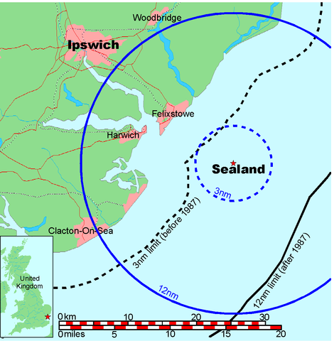
Map of Sealand This is a map of the coast of England near Ipswich, showing the location of Sealand. The boundaries of the territorial water of the United Kingdom are also drawn, both the 3 nautical mile limit (5.556km) before 1987 and the 12nm limit (22.22km) after 1987. The same radii are also given around Sealand. Note that these boundaries are derived based on the circular distance from the coastline, and not copied from official maps. This map is not suitable for navigation or for determining the boundaries of the UK territorial waters for legal or other purposes.
|
|||||||||
| Alkotó |
Map generated by DEMIS World Map Server and edited by Chris 73 |
|||||||||
| Engedély (Fájl újrafelhasználása) |
|
|||||||||
| Geotemporal data | ||||||||||
| Bounding box |
|
|||||||||
| Georeferencing | ||||||||||

Fájltörténet
Kattints egy időpontra, hogy a fájl akkori állapotát láthasd.
| Dátum/idő | Bélyegkép | Felbontás | Feltöltő | Megjegyzés | |
|---|---|---|---|---|---|
| aktuális | 2006. július 9., 21:41 | | 1 174 × 1 200 (55 KB) | Chris 73 | update |
| 2005. január 26., 12:00 |  | 1 024 × 1 046 (50 KB) | Chris 73 |
Fájlhasználat
Az alábbi lap használja ezt a fájlt:
Globális fájlhasználat
A következő wikik használják ezt a fájlt:
- Használata itt: af.wikipedia.org
- Használata itt: be-tarask.wikipedia.org
- Használata itt: be.wikipedia.org
- Használata itt: de.wikipedia.org
- Használata itt: en.wikipedia.org
- Használata itt: eo.wikipedia.org
- Használata itt: fy.wikipedia.org
- Használata itt: hi.wikipedia.org
- Használata itt: hr.wikipedia.org
- Használata itt: ko.wikipedia.org
- Használata itt: lb.wikipedia.org
- Használata itt: os.wikipedia.org
- Használata itt: pl.wikipedia.org
- Használata itt: wa.wikipedia.org