Fájl:Map of population density, South Australia and southern Northern Territory (2018) with railway lines to Alice Springs overlaid.png

Az előnézet mérete: 411 × 599 képpont További felbontások: 164 × 240 képpont | 329 × 480 képpont | 527 × 768 képpont | 702 × 1 024 képpont | 1 529 × 2 229 képpont.
Eredeti fájl (1 529 × 2 229 képpont, fájlméret: 1,21 MB, MIME-típus: image/png)
|
Ez a fájl a Wikimedia Commonsból származik. Az alább látható leírás az ottani dokumentációjának másolata. A Commons projekt szabad licencű kép- és multimédiatár. Segíts te is az építésében! |
_with_railway_lines_to_Alice_Springs_overlaid.png)
Összefoglaló
| Leírás |
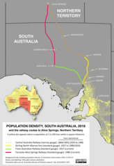
English: Map of population density in South Australia and the southern part of the Northern Territory in 2018 (© Australian Government 2020). The routes of past and present railway lines from Port Augusta / Stirling North to Alice Springs are overlaid on the map (CC0 SCHolar44), demonstrating the extremely low populations along the routes. Settlements on the route of the former Central Australia Railway, which closed in 1980, are much diminished in population but still trace the railway's route. |
| Dátum | |
| Forrás | Australian Bureau of Statistics -- https://www.abs.gov.au/AUSSTATS/abs@.nsf/DetailsPage/3218.02017-18 |
| Szerző | Australian Bureau of Statistics staff |
Licenc
Ez a fájl a Creative Commons Nevezd meg! 4.0 Nemzetközi licenc alapján használható fel.
Így nevezd meg: Australian Government
The Australian Government owns copyright in this work. Under its Public Data Policy, it has made non-sensitive data open by default, with licensing under a Creative Commons BY Attribution licence.
The Australian Government owns copyright in this work. Under its Public Data Policy, it has made non-sensitive data open by default, with licensing under a Creative Commons BY Attribution licence.
- A következőket teheted a művel:
- megoszthatod – szabadon másolhatod, terjesztheted, bemutathatod és előadhatod a művet
- feldolgozhatod – származékos műveket hozhatsz létre
- Az alábbi feltételekkel:
- Nevezd meg! – A szerzőt megfelelően fel kell tüntetned, hivatkozást kell létrehoznod a licencre és jelezned kell, ha a művön változtatást hajtottál végre. Ezt bármilyen észszerű módon megteheted, kivéve oly módon, ami azt sugallná hogy a jogosult támogat téged vagy a felhasználásod körülményeit.
Fájltörténet
Kattints egy időpontra, hogy a fájl akkori állapotát láthasd.
| Dátum/idő | Bélyegkép | Felbontás | Feltöltő | Megjegyzés | |
|---|---|---|---|---|---|
| aktuális | 2020. július 14., 12:23 | | 1 529 × 2 229 (1,21 MB) | SCHolar44 | Uploaded a work by Australian Bureau of Statistics staff from Australian Bureau of Statistics -- https://www.abs.gov.au/AUSSTATS/abs@.nsf/DetailsPage/3218.02017-18 with UploadWizard |
Fájlhasználat
Az alábbi lap használja ezt a fájlt:
_with_railway_lines_to_Alice_Springs_overlaid.png)