Fájl:Map of the route of Edward III's chevauchée of 1346.svg

Eredeti fájl (SVG fájl, névlegesen 1 059 × 988 képpont, fájlméret: 450 KB)
|
Ez a fájl a Wikimedia Commonsból származik. Az alább látható leírás az ottani dokumentációjának másolata. A Commons projekt szabad licencű kép- és multimédiatár. Segíts te is az építésében! |
Összefoglaló
| Leírás |
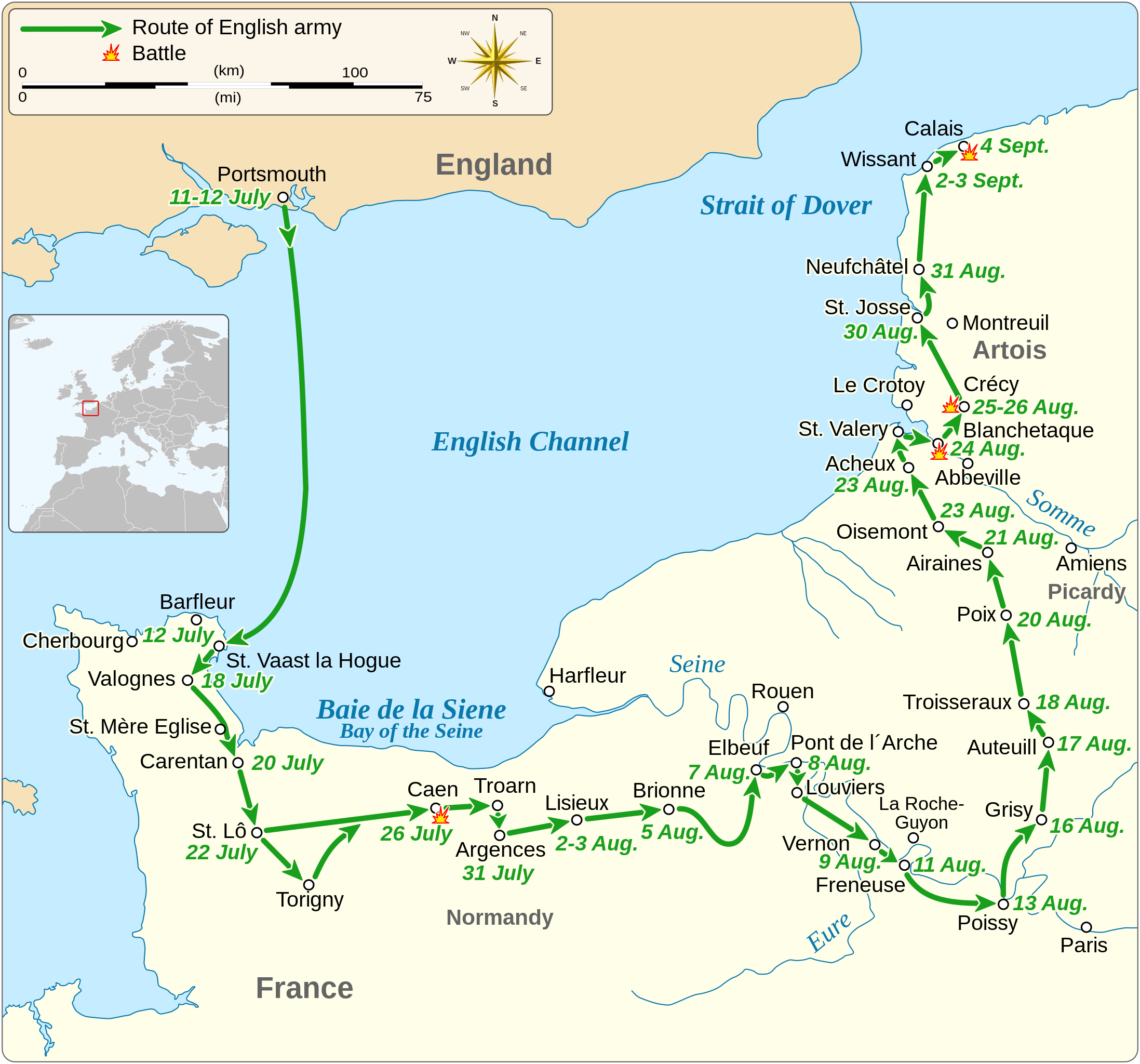
English: Map of the route of Edward III's chevauchée of 1346, part of the Hundred Years' War. This map shows the English army movements during the campaign and the most important battles.
|
||||||||||||||||||||||||||||||||||||||||||||||||||||||||||
| Dátum | |||||||||||||||||||||||||||||||||||||||||||||||||||||||||||
| Forrás |
A feltöltő saját munkája Derived from; Information from:
|
||||||||||||||||||||||||||||||||||||||||||||||||||||||||||
| Szerző | Goran tek-en | ||||||||||||||||||||||||||||||||||||||||||||||||||||||||||
| Engedély (Fájl újrafelhasználása) |
Ez a fájl a Creative Commons Nevezd meg! – Így add tovább! 4.0 Nemzetközi licenc alapján használható fel. Így nevezd meg: Goran tek-en
|
||||||||||||||||||||||||||||||||||||||||||||||||||||||||||
| SVG kód | Ez vektorgrafikus kép Inkscape segítségével készült. |
||||||||||||||||||||||||||||||||||||||||||||||||||||||||||


| Objektum elhelyezkedése | | További képek erről a helyről: OpenStreetMap |
|---|


Fájltörténet
Kattints egy időpontra, hogy a fájl akkori állapotát láthasd.
| Dátum/idő | Bélyegkép | Felbontás | Feltöltő | Megjegyzés | |
|---|---|---|---|---|---|
| aktuális | 2022. február 3., 02:14 | | 1 059 × 988 (450 KB) | Iso10970 | Reverted to version as of 13:17, 9 November 2021 (UTC) |
| 2022. február 3., 02:13 |  | 1 059 × 988 (614 KB) | Iso10970 | File uploaded using svgtranslate tool (https://svgtranslate.toolforge.org/). Added translation for ja. | |
| 2021. november 9., 15:17 |  | 1 059 × 988 (450 KB) | Goran tek-en | Changed view box, font size, added location map | |
| 2019. április 14., 15:06 |  | 1 059 × 988 (191 KB) | Goran tek-en | Spelling | |
| 2019. március 10., 19:53 |  | 1 059 × 988 (115 KB) | JoKalliauer | phab:T36947 bad character aligment on same sizes | |
| 2019. március 6., 16:08 |  | 1 059 × 988 (191 KB) | Goran tek-en | {{Information |description ={{en|1=Map of the route of Edward III's chevauchée of 1346, part of the Hundred Years' War. This map shows the English army movements during the campaign and the most important battles.}} |date =20190306 |source ={{Own}}<br> Derived from; * [https://www.openstreetmap.org/#map=8/49.919/1.371 OSM] Information from: * [https://www.themaparchive.com/the-crecy-campaign-12-july-to-4-september-1346.html themaparchive.com] * {{U|Newm30}} |author... |
Fájlhasználat
Az alábbi lapok használják ezt a fájlt:
Globális fájlhasználat
A következő wikik használják ezt a fájlt:
- Használata itt: cs.wikipedia.org
- Használata itt: en.wikipedia.org
- Használata itt: es.wikipedia.org
- Használata itt: fi.wikipedia.org
- Használata itt: fr.wikipedia.org
- Használata itt: ja.wikipedia.org
- Használata itt: nl.wikipedia.org
- Használata itt: pt.wikipedia.org
- Használata itt: ru.wikipedia.org
- Használata itt: sh.wikipedia.org
- Használata itt: tr.wikipedia.org
- Használata itt: zh.wikipedia.org