Fájl:Mapa de Venezuela, N. Granada y Quito, 1821.jpg

Eredeti fájl (2 417 × 1 737 képpont, fájlméret: 1,43 MB, MIME-típus: image/jpeg)
|
Ez a fájl a Wikimedia Commonsból származik. Az alább látható leírás az ottani dokumentációjának másolata. A Commons projekt szabad licencű kép- és multimédiatár. Segíts te is az építésében! |
Összefoglaló
| Leírás |
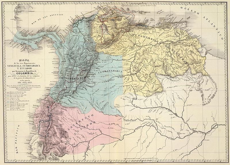
Español: Mapa de los tres departamentos Venezuela, Cundinamarca y Quito, que confomaron la República de Colombia y que muestra las campañas de la guerra de independencia entre 1821 y 1823. Tomado del "Atlas físico y político de la República de Venezuela", 1840. |
||||||||||||||||||||
| Dátum | |||||||||||||||||||||
| Forrás | Historical Maps by Agustín Codazzi, from David Rumsey Website | ||||||||||||||||||||
| Szerző |
|
||||||||||||||||||||

Licenc
|
Ez a mű közkincs abban az országban, ahol elkészítették, és minden olyan további államban, ahol a szerzői jogi védelmi idő a szerző élete plusz 70 év vagy kevesebb.
| |
| Megállapították, hogy ez a fájl mentes mindenféle szerzői jogi korlátozástól, beleértve az összes kapcsolódó és hozzátartozó jogot. | |
Fájltörténet
Kattints egy időpontra, hogy a fájl akkori állapotát láthasd.
| Dátum/idő | Bélyegkép | Felbontás | Feltöltő | Megjegyzés | |
|---|---|---|---|---|---|
| aktuális | 2008. június 6., 08:01 | | 2 417 × 1 737 (1,43 MB) | Milenioscuro | {{Information |Description= |Source= |Date= |Author= |Permission= |other_versions= }} |
| 2008. január 3., 14:24 |  | 1 247 × 903 (368 KB) | Milenioscuro | {{Information |Description=Gran Colombia dividida en 3 departamentos en 1821 |Source=http://www.davidrumsey.com |Date=1840 |Author=Agustín Codazzi |Permission= |other_versions= }} Category:Gran Colombia Category:Old maps of Colombia [[Category:Ol |
Fájlhasználat
Az alábbi lap használja ezt a fájlt:
Globális fájlhasználat
A következő wikik használják ezt a fájlt:
- Használata itt: ar.wikipedia.org
- Használata itt: en.wikipedia.org
- Használata itt: es.wikipedia.org
- Használata itt: fr.wikipedia.org
- Használata itt: gl.wikipedia.org
- Használata itt: guc.wikipedia.org
- Használata itt: ia.wikipedia.org
- Használata itt: it.wikipedia.org
- Használata itt: ja.wikipedia.org
- Használata itt: pt.wikipedia.org
- Használata itt: sl.wikipedia.org
- Használata itt: sq.wikipedia.org
- Használata itt: te.wikipedia.org