Fájl:Memorial to the Aer Lingus crash of January 1952 - 1784244.jpg
Eredeti fájl (1 024 × 714 képpont, fájlméret: 224 KB, MIME-típus: image/jpeg)
|
Ez a fájl a Wikimedia Commonsból származik. Az alább látható leírás az ottani dokumentációjának másolata. A Commons projekt szabad licencű kép- és multimédiatár. Segíts te is az építésében! |
Összefoglaló
| Leírás |
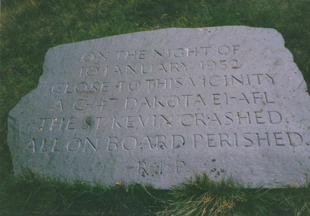
English: Memorial to the passengers and crew of Aer Lingus crash of 10 January 1952, 4 km from Plas Gwynant, Gwynedd, Great Britain.
The Douglas DC-3 (named 'Saint Kevin') owned by Aer Lingus left RAF Northolt, London at 17:25 on 10th January, 1952 on a flight to Dublin. Radio contact with the plane was lost shortly after the pilot requested permission from Dublin control at around 19:15 to descend from 6500 ft to 4500 ft. A board of inquiry came to the conclusion that the descending plane encountered a "powerful down-current of air on the lee side of Snowdon which forced the aircraft down into an area of very great turbulence .." which led the pilot, Capt Keohane, to "lose control.." Even in mid summer, the Cwm Edno bog at 1.500ft, is an inhospitable place. The conditions on that night in January, 1952 were absolutely atrocious. I remember at the time Police Constable Jones, stationed at Deiniolen, describing the scene of utter devastation which met officers who had had to climb for almost an hour to the site from the Llyn Gwynant road, how sections of the wreckage and many bodies had been sucked into the muddy bog and how a little child's doll had on impact been thrown clear of the burning wreckage, something which upset the men greatly. |
| Dátum | |
| Forrás | From this image at geograph.org.uk; transferred by User:RHaworth using geograph_org2commons. |
| Szerző | Eric Jones |
| Más változatok |
|
| Így nevezd meg (a licenc megköveteli) | Eric Jones / Memorial to the passengers and crew of Aer Lingus crash of 10th January 1952 / |


| Fényképező elhelyezkedése | | További képek erről a helyről: OpenStreetMap |
|---|
| Objektum elhelyezkedése | | További képek erről a helyről: OpenStreetMap |
|---|
_region:GB-GBN_heading:157.00&language=hu)
Licenc

|
This image was taken from the Geograph project collection. See this photograph's page on the Geograph website for the photographer's contact details. The copyright on this image is owned by Eric Jones and is licensed for reuse under the Creative Commons Attribution-ShareAlike 2.0 license.
|
- A következőket teheted a művel:
- megoszthatod – szabadon másolhatod, terjesztheted, bemutathatod és előadhatod a művet
- feldolgozhatod – származékos műveket hozhatsz létre
- Az alábbi feltételekkel:
- Nevezd meg! – A szerzőt megfelelően fel kell tüntetned, hivatkozást kell létrehoznod a licencre és jelezned kell, ha a művön változtatást hajtottál végre. Ezt bármilyen észszerű módon megteheted, kivéve oly módon, ami azt sugallná hogy a jogosult támogat téged vagy a felhasználásod körülményeit.
- Így add tovább! – Ha megváltoztatod, átalakítod, feldolgozod ezt a művet, a közreműködésedet csak az eredetivel megegyező vagy hasonló licenc alatt terjesztheted.
Fájltörténet
Kattints egy időpontra, hogy a fájl akkori állapotát láthasd.
| Dátum/idő | Bélyegkép | Felbontás | Feltöltő | Megjegyzés | |
|---|---|---|---|---|---|
| aktuális | 2010. szeptember 28., 00:49 | | 1 024 × 714 (224 KB) | File Upload Bot (Magnus Manske) | == {{int:filedesc}} == {{Information |Description={{en|1=Memorial to the passengers and crew of Aer Lingus crash of 10th January 1952, 4 km from Plas Gwynant, Gwynedd, Great Britain. The Douglas DC-3 (named 'Saint Kevin') owned by Aer Lingus lef |
Fájlhasználat
Az alábbi lap használja ezt a fájlt:
Globális fájlhasználat
A következő wikik használják ezt a fájlt:
- Használata itt: en.wikipedia.org
- Használata itt: ja.wikipedia.org
- Használata itt: tr.wikipedia.org