Fájl:PIA21284 - Lanzarote, Canary Islands.jpg

Eredeti fájl (3 367 × 3 672 képpont, fájlméret: 1,03 MB, MIME-típus: image/jpeg)
|
Ez a fájl a Wikimedia Commonsból származik. Az alább látható leírás az ottani dokumentációjának másolata. A Commons projekt szabad licencű kép- és multimédiatár. Segíts te is az építésében! |
Összefoglaló
| Leírás |
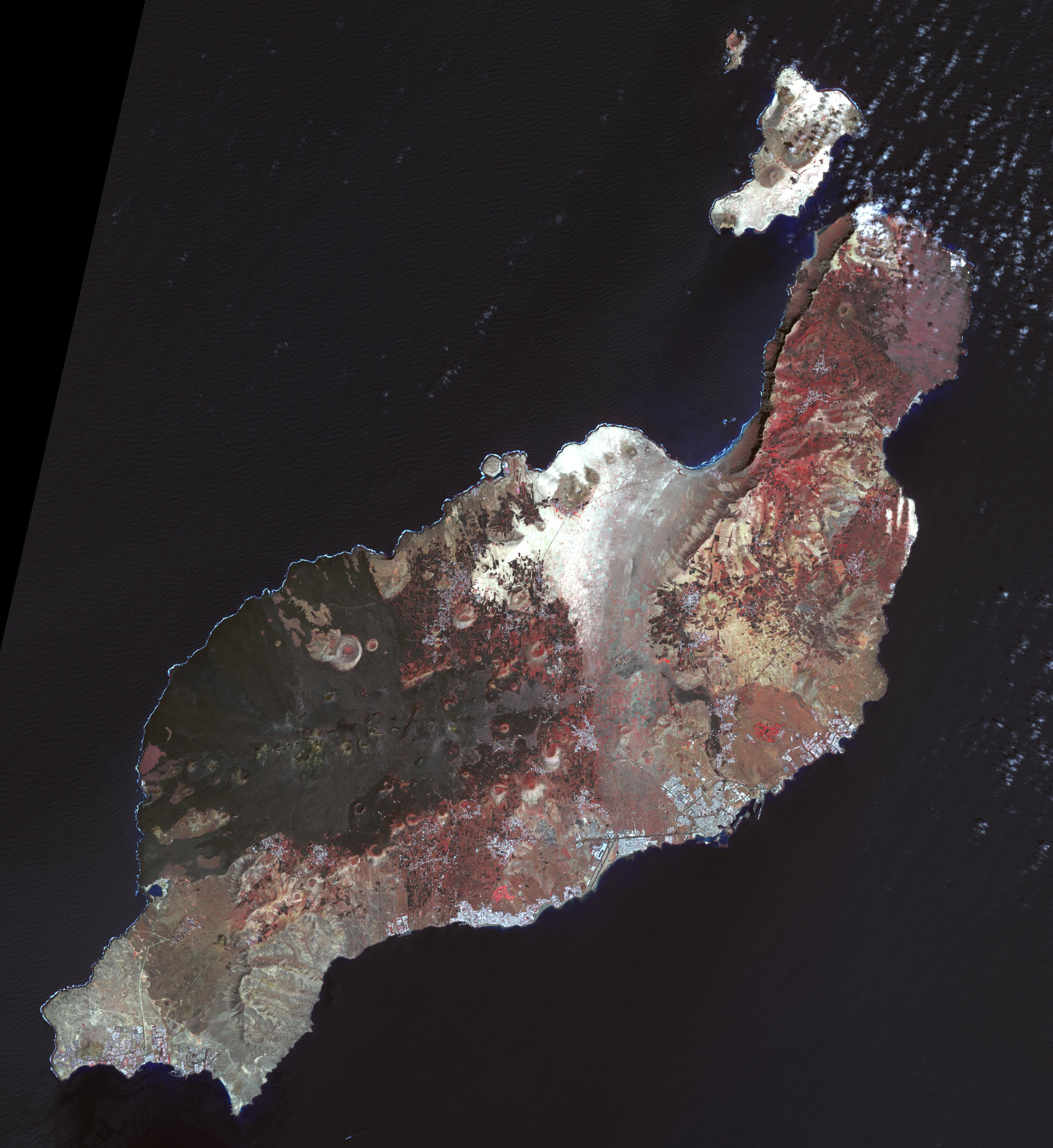
English: Lanzarote is the easternmost of the Canary Islands, 125 km off the coast of Africa, and is the fourth largest of the archipelago, with an area of 846 square kilometers. Like all of the Canary Islands, its volcanic origin dates to about 15 million years ago. The largest historic eruption occurred in the 1730s. The island was first recorded by Pliny the Elder, though it may have been originally settled by the Phoenicians (Wikipedia). The image was acquired 12 March 2015, covers an area of 50.5 by 55.1 km, and is located near 29 degrees north, 13.6 degrees west.
With its 14 spectral bands from the visible to the thermal infrared wavelength region and its high spatial resolution of 15 to 90 meters (about 50 to 300 feet), ASTER images Earth to map and monitor the changing surface of our planet. ASTER is one of five Earth-observing instruments launched Dec. 18, 1999, on Terra. The instrument was built by Japan's Ministry of Economy, Trade and Industry. A joint U.S./Japan science team is responsible for validation and calibration of the instrument and data products. The broad spectral coverage and high spectral resolution of ASTER provides scientists in numerous disciplines with critical information for surface mapping and monitoring of dynamic conditions and temporal change. Example applications are: monitoring glacial advances and retreats; monitoring potentially active volcanoes; identifying crop stress; determining cloud morphology and physical properties; wetlands evaluation; thermal pollution monitoring; coral reef degradation; surface temperature mapping of soils and geology; and measuring surface heat balance. The U.S. science team is located at NASA's Jet Propulsion Laboratory, Pasadena, Calif. The Terra mission is part of NASA's Science Mission Directorate, Washington, D.C. More information about ASTER is available at http://asterweb.jpl.nasa.gov/. |
| Dátum | 12 March 2015 (published 6 January 2017) |
| Forrás | Catalog page · Full-res (JPEG · TIFF) |
| Szerző | NASA/METI/AIST/Japan Space Systems, and U.S./Japan ASTER Science Team |
| Fényképező elhelyezkedése | | További képek erről a helyről: OpenStreetMap |
|---|
Ezt a képet vagy videót az Amerikai Egyesült Államok Nemzeti Légügyi és Űrhajózási Hivatalának (NASA) Sugárhajtás Laboratóriumakategorizálta a következő azonosító kód alatt: fénykép-azonosító: PIA21284. Ez a sablon nem a licenc jelölésére szolgál. Szükség van egy licencsablonra is. Lásd a Commons:Licencelés lapot. Más nyelvek:
|
| This media is a product of the Terra mission Credit and attribution belongs to the Advanced Spaceborne Thermal Emission and Reflection Radiometer (ASTER) team, NASA/METI/AIST/Japan Space Systems |
Licenc
| Ezt a fájlt a NASA készítette, ezért az Egyesült Államokban közkincsnek számít. A NASA szerzői jogi irányelve alapján „a NASA anyagai nem állnak szerzői jogi védelem alatt, kivéve, ha az külön jelezve van". (Lásd még: Sablon:PD-USGov, a NASA szerzői jogi- és a JPL képhasználati irányelve.) | ||
 |
Figyelmeztetések:
|
| Képjegyzetek | Ehhez a képhez képjegyzetek tartoznak: Képjegyzetek megtekintése a Commonson |
Fájltörténet
Kattints egy időpontra, hogy a fájl akkori állapotát láthasd.
| Dátum/idő | Bélyegkép | Felbontás | Feltöltő | Megjegyzés | |
|---|---|---|---|---|---|
| aktuális | 2017. január 30., 01:03 | | 3 367 × 3 672 (1,03 MB) | PhilipTerryGraham | User created page with UploadWizard |
Fájlhasználat
Az alábbi lap használja ezt a fájlt: