Fájl:Shakemap Ecuador April 2016.jpg
Az előnézet mérete: 456 × 599 képpont További felbontások: 183 × 240 képpont | 365 × 480 képpont | 762 × 1 001 képpont.
Eredeti fájl (762 × 1 001 képpont, fájlméret: 288 KB, MIME-típus: image/jpeg)
|
Ez a fájl a Wikimedia Commonsból származik. Az alább látható leírás az ottani dokumentációjának másolata. A Commons projekt szabad licencű kép- és multimédiatár. Segíts te is az építésében! |
Összefoglaló
| Leírás |
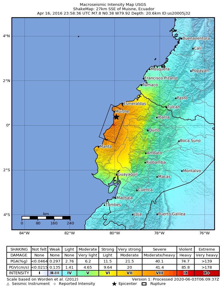
English: Shakemap for the 2016 Ecuador earthquake
Español: Mapa de intensidades sísmicas para el terremoto de Ecuador de 2016
Magyar: A 2016-os ecuadori földrengés rengéseinek térképe |
| Dátum | |
| Forrás | https://earthquake.usgs.gov/earthquakes/eventpage/us20005j32#shakemap |
| Szerző | United States Geological Survey |
Licenc
This image is in the public domain in the United States because it only contains materials that originally came from the United States Geological Survey, an agency of the United States Department of the Interior. For more information, see the official USGS copyright policy.
|
Fájltörténet
Kattints egy időpontra, hogy a fájl akkori állapotát láthasd.
| Dátum/idő | Bélyegkép | Felbontás | Feltöltő | Megjegyzés | |
|---|---|---|---|---|---|
| aktuális | 2023. június 25., 21:36 | | 762 × 1 001 (288 KB) | 4kolechia | added newer version |
| 2016. április 17., 21:23 |  | 2 125 × 2 480 (1,76 MB) | Kiwi128 | higher resolution version rendered from postscript file | |
| 2016. április 17., 18:07 |  | 612 × 717 (102 KB) | Skycycle | Update via USGS, new intensity and depth | |
| 2016. április 17., 02:39 |  | 612 × 717 (100 KB) | GroundControl01 | User created page with UploadWizard |
Fájlhasználat
Az alábbi lap használja ezt a fájlt:
Globális fájlhasználat
A következő wikik használják ezt a fájlt:
- Használata itt: ar.wikipedia.org
- Használata itt: bg.wikipedia.org
- Használata itt: de.wikipedia.org
- Használata itt: en.wikipedia.org
- Használata itt: es.wikipedia.org
- Használata itt: es.wikinews.org
- Használata itt: fi.wikipedia.org
- Használata itt: fr.wikipedia.org
- Használata itt: hi.wikipedia.org
- Használata itt: hy.wikipedia.org
- Használata itt: id.wikipedia.org
- Használata itt: it.wikipedia.org
- Használata itt: ja.wikipedia.org
- Használata itt: ko.wikipedia.org
- Használata itt: ky.wikipedia.org
- Használata itt: la.wikipedia.org
- Használata itt: ms.wikipedia.org
- Használata itt: nl.wikipedia.org
- Használata itt: no.wikipedia.org
- Használata itt: ro.wikipedia.org
- Használata itt: ru.wikipedia.org
- Használata itt: ru.wikinews.org
- Használata itt: uk.wikipedia.org
- Használata itt: vi.wikipedia.org