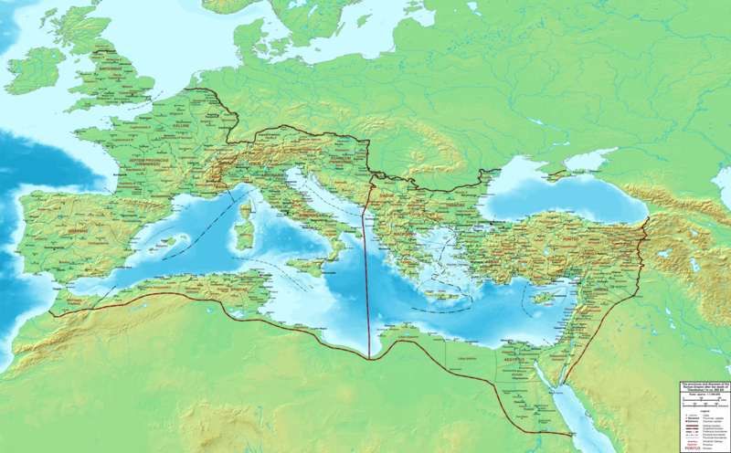
Fájl:The Roman Empire ca 400 AD.png

Az előnézet mérete: 800 × 496 képpont További felbontások: 320 × 198 képpont | 640 × 397 képpont | 1 024 × 635 képpont | 1 280 × 793 képpont | 2 560 × 1 587 képpont | 4 339 × 2 689 képpont.
Eredeti fájl (4 339 × 2 689 képpont, fájlméret: 12,8 MB, MIME-típus: image/png)
Fájltörténet
Kattints egy időpontra, hogy a fájl akkori állapotát láthasd.
| Dátum/idő | Bélyegkép | Felbontás | Feltöltő | Megjegyzés | |
|---|---|---|---|---|---|
| aktuális | 2015. február 20., 00:27 |  | 4 339 × 2 689 (12,8 MB) | Cplakidas | added potential location of Valentia beyond Hadrian's Wall, removed provincial boundaries in Britannia as too tentative |
| 2011. július 21., 15:03 |  | 4 339 × 2 689 (10,9 MB) | Cplakidas | fixed Persian border, differentiated between Eastern and Western empire, different borders for praet. prefectures | |
| 2009. március 21., 04:37 |  | 4 475 × 2 600 (9,99 MB) | Cplakidas | minor corrections | |
| 2008. május 29., 14:30 |  | 3 800 × 2 370 (8,1 MB) | Cplakidas | ||
| 2008. május 29., 14:17 |  | 4 560 × 2 850 (11,22 MB) | Cplakidas | clearer version & addition of the Armenian satrapies | |
| 2007. december 30., 04:02 |  | 3 380 × 2 120 (5,96 MB) | Cplakidas | added names of dioceses, legend box, various minor adjustments | |
| 2007. december 13., 16:27 |  | 3 550 × 2 200 (6,65 MB) | Cplakidas | new improved version made with Inkscape, slight corrections in borders, added several cities in Africa & Spain | |
| 2007. november 12., 21:27 |  | 3 550 × 2 200 (4,75 MB) | Cplakidas | minor corrections in southern Gaul | |
| 2007. november 5., 14:58 |  | 3 550 × 2 200 (4,75 MB) | Cplakidas | New version, with some corrections & additions | |
| 2007. október 31., 18:55 |  | 3 436 × 2 142 (4,5 MB) | Cplakidas | {{Information |Description=Map of the Roman Empire ca. 400 AD, showing the administrative division into dioceses and provinces, as well as the major cities. The demarcation between Eastern and Western Empires is noted in red. |Source=Base map found at |
Fájlhasználat
Az alábbi lap használja ezt a fájlt:
Globális fájlhasználat
A következő wikik használják ezt a fájlt:
- Használata itt: af.wikipedia.org
- Használata itt: ar.wikipedia.org
- Használata itt: ary.wikipedia.org
- Használata itt: ast.wikipedia.org
- Használata itt: bg.wikipedia.org
- Használata itt: bn.wikipedia.org
- Használata itt: ca.wikipedia.org
- Használata itt: ceb.wikipedia.org
- Használata itt: cs.wikipedia.org
- Használata itt: de.wikipedia.org
- Használata itt: el.wikipedia.org
- Használata itt: en.wikipedia.org
- Használata itt: eo.wikipedia.org
- Használata itt: es.wikipedia.org
- Használata itt: et.wikipedia.org
- Használata itt: fr.wikipedia.org
- Használata itt: he.wikipedia.org
- Használata itt: hi.wikipedia.org
- Használata itt: hr.wikipedia.org
- Használata itt: id.wikipedia.org
- Használata itt: it.wikipedia.org
- Használata itt: ko.wikipedia.org
- Használata itt: la.wikipedia.org
- Használata itt: lt.wikipedia.org
- Használata itt: nl.wikipedia.org
- Használata itt: no.wikipedia.org
A fájl globális használatának megtekintése


