Fájl:Ww2 europe map italy june until december 1944.jpg

Az előnézet mérete: 785 × 599 képpont További felbontások: 314 × 240 képpont | 629 × 480 képpont | 1 006 × 768 képpont | 1 265 × 966 képpont.
Eredeti fájl (1 265 × 966 képpont, fájlméret: 1,89 MB, MIME-típus: image/jpeg)
|
Ez a fájl a Wikimedia Commonsból származik. Az alább látható leírás az ottani dokumentációjának másolata. A Commons projekt szabad licencű kép- és multimédiatár. Segíts te is az építésében! |
Összefoglaló
| Leírás |
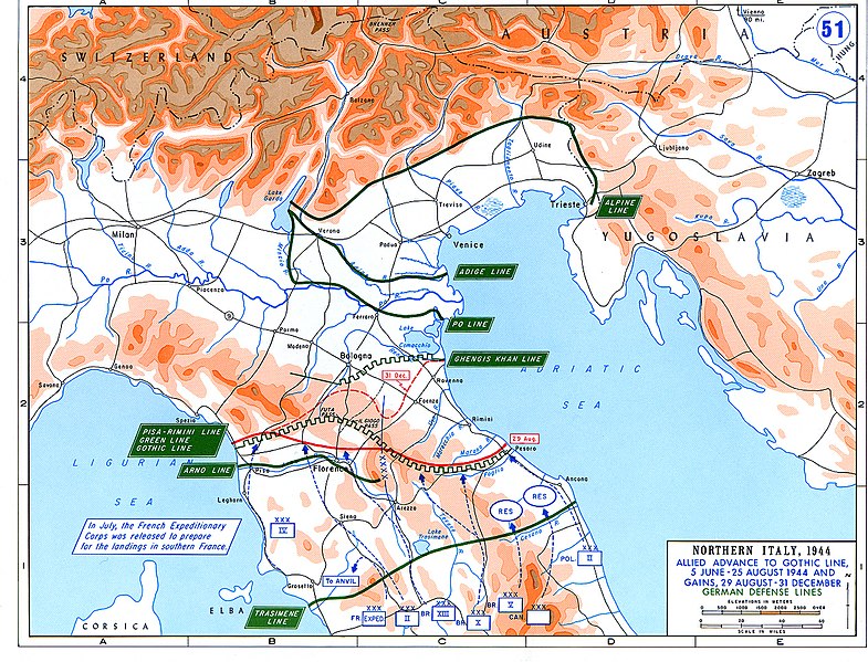
English: Allied Corp formations are depicted in blue. The German defensive lines are shown in green. The solid red line denotes the extent of the Allied advance by 29 August 1944, and the dotted red line is the extent of the Allied advance by 31 December 1944. |
| Dátum | |
| Forrás | Archive link to original website used for the map and the archive link to the map source page. |
| Szerző | The History Department of the United States Military Academy |
| Engedély (Fájl újrafelhasználása) |
US Government document |
| Más változatok |
The current version of the map by the The History Department of the United States Military Academy: |

Licenc
Ezt a képet az Amerikai Egyesült Államok Szárazföldi Erőinek egy katonája vagy munkatársa készítette szolgálati ideje alatt. Az Egyesült Államok jogszabályai értelmében ez a kép közkincsnek minősül.
|
 |
Fájltörténet
Kattints egy időpontra, hogy a fájl akkori állapotát láthasd.
| Dátum/idő | Bélyegkép | Felbontás | Feltöltő | Megjegyzés | |
|---|---|---|---|---|---|
| aktuális | 2021. február 20., 05:25 | | 1 265 × 966 (1,89 MB) | Buidhe | Reverted to version as of 14:07, 29 February 2020 (UTC) Not a minor change, should be uploaded as new file |
| 2021. február 20., 04:57 |  | 973 × 754 (349 KB) | EnigmaMcmxc | updated version of the map | |
| 2020. február 29., 16:07 |  | 1 265 × 966 (1,89 MB) | Hohum | Fix colour profile | |
| 2011. június 22., 20:21 |  | 1 265 × 966 (1,93 MB) | Hohum | Cleanup | |
| 2006. december 10., 14:26 |  | 1 265 × 966 (2,01 MB) | MatthiasKabel | == License information == {{PD-Layout}} {{PD-USGov}} Original from http://www.dean.usma.edu/history/web03/atlases/ww2%20europe/ww2%20europe%20war%20index.htm |
Fájlhasználat
Az alábbi lap használja ezt a fájlt:
Globális fájlhasználat
A következő wikik használják ezt a fájlt:
- Használata itt: af.wikipedia.org
- Használata itt: ar.wikipedia.org
- Használata itt: cs.wikipedia.org
- Használata itt: de.wikipedia.org
- Használata itt: en.wikipedia.org
- Használata itt: es.wikipedia.org
- Használata itt: fi.wikipedia.org
- Használata itt: fr.wikipedia.org
- Használata itt: he.wikipedia.org
- Használata itt: id.wikipedia.org
- Használata itt: it.wikipedia.org
- Használata itt: ja.wikipedia.org
- Használata itt: nl.wikipedia.org
- Használata itt: no.wikipedia.org
- Használata itt: pl.wikipedia.org
- Használata itt: pt.wikipedia.org
- Használata itt: ru.wikipedia.org
- Használata itt: sk.wikipedia.org
- Használata itt: sl.wikipedia.org
- Használata itt: sr.wikipedia.org
- Használata itt: sv.wikipedia.org
- Használata itt: ta.wikipedia.org
- Használata itt: uk.wikipedia.org
- Használata itt: www.wikidata.org
- Használata itt: zh.wikipedia.org