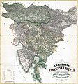
Fájl:Zemljovid slovenske dežele in pokrajin (Original).jpg

Az előnézet mérete: 558 × 599 képpont További felbontások: 223 × 240 képpont | 447 × 480 képpont | 715 × 768 képpont | 953 × 1 024 képpont | 1 906 × 2 048 képpont | 5 949 × 6 391 képpont.
Eredeti fájl (5 949 × 6 391 képpont, fájlméret: 32,52 MB, MIME-típus: image/jpeg)
Fájltörténet
Kattints egy időpontra, hogy a fájl akkori állapotát láthasd.
| Dátum/idő | Bélyegkép | Felbontás | Feltöltő | Megjegyzés | |
|---|---|---|---|---|---|
| aktuális | 2022. június 17., 23:51 |  | 5 949 × 6 391 (32,52 MB) | Ранко Николић | Cropped 7 % horizontally, 20 % vertically using CropTool with precise mode. |
| 2013. július 17., 16:48 |  | 6 385 × 7 989 (25,22 MB) | Sporti | better res | |
| 2011. december 6., 01:08 |  | 1 888 × 2 040 (1,17 MB) | Ras67 | losslessly cropped with Jpegcrop | |
| 2011. szeptember 9., 12:26 |  | 2 000 × 2 502 (1,24 MB) | Ipos | {{Information |Description ={{en|1={{sl|Zemljevid Slovenske dežele in pokrajin, autor sl:Peter Kozler}} {{en|A map of the Slovene Land and Provinces, author en:Peter Kozler}} {{hr|Zemljovid slovenskih zemalja i pokrajina, autor [[:hr:Peter K |
Fájlhasználat
Az alábbi lap használja ezt a fájlt:
Globális fájlhasználat
A következő wikik használják ezt a fájlt:
- Használata itt: ar.wikipedia.org
- Használata itt: azb.wikipedia.org
- Használata itt: cs.wikipedia.org
- Használata itt: de.wikipedia.org
- Használata itt: en.wikipedia.org
- Használata itt: es.wikipedia.org
- Használata itt: et.wikipedia.org
- Használata itt: he.wikipedia.org
- Használata itt: hr.wikipedia.org
- Használata itt: id.wikipedia.org
- Használata itt: it.wikipedia.org
- Használata itt: mk.wikipedia.org
- Használata itt: sl.wikipedia.org
- Használata itt: sr.wikipedia.org
