Fájl:ఆంధ్రప్రదేశ్ జిల్లాల పటము.png

Eredeti fájl(2 487 × 2 066 képpont, fájlméret: 790 KB, MIME-típus: image/png)

Összefoglaló

Leírás
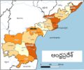
English: Andhra Pradesh Districts map after After Andhra Pradesh Reorganisation in 2014 with Telugu Legend].

Inputs: OSM Data as on 2021-12-24

2)River shapes from Natural Earth ( Rivers + lake centerlines Version 4.1.0, Lakes + Reservoirs Version 4.1.0: http://www.naturalearthdata.com/downloads/10m-physical-vectors/ )

Processing using QGIS version 3.16.1


CRS EPSG:4326 - WGS 84 - Geographic

Extent 76.6123255059557806,12.4375674499940345 : 84.9528352876628219,19.3353756498417759

Unit degrees

For qgis files: check https://github.com/arjunaraoc/indiagisdata/apdistrict-osm
Dátum
Forrás A feltöltő saját munkája
Szerző Arjunaraoc
Más változatok English version

Licenc

Én, e mű szerzője a művemet az alábbi licenc alatt teszem közzé:
This work contains information from OpenStreetMap, which is made available under the Open Database License (ODbL).

The ODbL does not require any particular license for maps produced from ODbL data. Prior to 1 August 2020, map tiles produced by the OpenStreetMap Foundation were licensed under the CC-BY-SA-2.0 license. Maps produced by other people may be subject to other licences.

Képaláírások

Adj meg egy egysoros magyarázatot arról, hogy mit mutat be ez a fájl
Andhra Pradesh Districts(26) map after After Andhra Pradesh Reorganisation in 2022 with Telugu Legend with new 13 new districts total of

A fájl által ábrázolt elemek

mű tárgya

27. március 2019

Fájltörténet

Kattints egy időpontra, hogy a fájl akkori állapotát láthasd.

Dátum/időBélyegképFelbontásFeltöltőMegjegyzés
aktuális2021. december 25., 15:57Bélyegkép a 2021. december 25., 15:57-kori változatról2 487 × 2 066 (790 KB)ArjunaraocAdded Yanam(Pondichery) Telugu label
2021. december 25., 15:41Bélyegkép a 2021. december 25., 15:41-kori változatról2 487 × 2 066 (776 KB)ArjunaraocMoved Telugu Label of Capital Amaravathi nearer to the location
2021. december 25., 14:53Bélyegkép a 2021. december 25., 14:53-kori változatról2 487 × 2 066 (774 KB)ArjunaraocPrepared with only OSM and natual earth data for clean borders
2019. március 27., 06:32Bélyegkép a 2019. március 27., 06:32-kori változatról2 485 × 2 064 (866 KB)ArjunaraocCropped to the drawing
2019. március 27., 06:28Bélyegkép a 2019. március 27., 06:28-kori változatról2 757 × 3 781 (877 KB)ArjunaraocUser created page with UploadWizard

Ezt a fájlt nem használja egyetlen lap sem.

Globális fájlhasználat

Metaadatok