Fájl:ACW Chattanooga2Carolinas.png
Az előnézet mérete: 800 × 426 képpont További felbontások: 320 × 170 képpont | 640 × 341 képpont | 1 024 × 545 képpont | 1 881 × 1 002 képpont.
Eredeti fájl (1 881 × 1 002 képpont, fájlméret: 429 KB, MIME-típus: image/png)
|
Ez a fájl a Wikimedia Commonsból származik. Az alább látható leírás az ottani dokumentációjának másolata. A Commons projekt szabad licencű kép- és multimédiatár. Segíts te is az építésében! |
Összefoglaló
| Leírás |
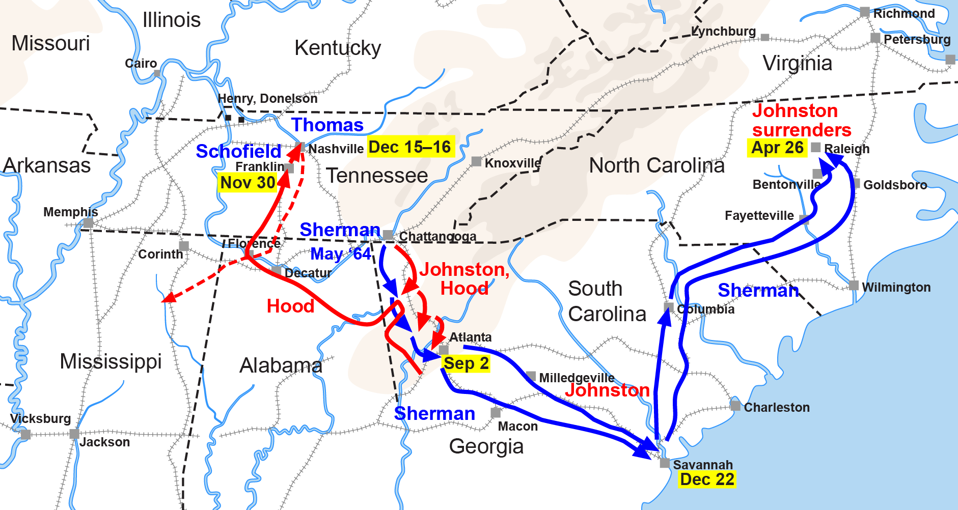
English: Map of the Western Theater of the American Civil War, actions from Chattanooga to the Carolinas. |
| Dátum | |
| Forrás | Drawn by Hal Jespersen in Adobe Illustrator CS5. Graphic source file is available at http://www.posix.com/CWmaps/ |
| Szerző | Hlj a(z) angol Wikipédia projektből |
| Más változatok |
|


Licenc
Ez a fájl a Creative Commons Nevezd meg! 3.0 Unported licenc alapján használható fel.
Így nevezd meg: Map by Hal Jespersen, www.posix.com/CW
- A következőket teheted a művel:
- megoszthatod – szabadon másolhatod, terjesztheted, bemutathatod és előadhatod a művet
- feldolgozhatod – származékos műveket hozhatsz létre
- Az alábbi feltételekkel:
- Nevezd meg! – A szerzőt megfelelően fel kell tüntetned, hivatkozást kell létrehoznod a licencre és jelezned kell, ha a művön változtatást hajtottál végre. Ezt bármilyen észszerű módon megteheted, kivéve oly módon, ami azt sugallná hogy a jogosult támogat téged vagy a felhasználásod körülményeit.
Eredeti feltöltési napló
Áthozta MaEr az it.wikipedia projektből a Commonsba.
Az eredeti leírólap itt volt. Az itt következő felhasználónevek az it.wikipedia projektre hivatkoznak.
- 2006-10-06 17:12 Starlight 1566×773×??? (316548 bytes) Map of the Western Theater of the American Civil War, actions from Chattanooga to the Carolinas. Drawn by Hal Jespersen in Macromedia Freehand. Graphic source file is available at http://www.posix.com/CWmaps/ {{PD}}
Az eredeti leírólap itt volt. Az itt következő felhasználónevek az en.wikipedia projektre hivatkoznak.
- 2006-03-31 00:30 Hlj 1566×773× (316548 bytes) Map of the [[Western Theater of the American Civil War]], actions from Chattanooga to the Carolinas. Drawn by Hal Jespersen in Macromedia Freehand. Graphic source file is available at http://www.posix.com/CWmaps/ {{PD-release}}
Fájltörténet
Kattints egy időpontra, hogy a fájl akkori állapotát láthasd.
| Dátum/idő | Bélyegkép | Felbontás | Feltöltő | Megjegyzés | |
|---|---|---|---|---|---|
| aktuális | 2011. március 25., 00:35 | | 1 881 × 1 002 (429 KB) | Hlj | Update to new graphical style for rivers. Same license. |
| 2009. február 6., 07:34 |  | 1 862 × 992 (309 KB) | Hlj | {{Information |Description=Map of Sherman's operations from Chattanooga through the Carolinas of the American Civil War. (Minor updates from previous version; new license.) Drawn in Adobe Illustrator CS3 by Hal Jespersen. Graphic source file is availa | |
| 2008. szeptember 14., 13:50 |  | 1 566 × 773 (309 KB) | MaEr | {{Information |Description={{en|Map of the Western Theater of the American Civil War, actions from Chattanooga to the Carolinas. Drawn by Hal Jespersen in Macromedia Freehand. Graphic source file is available at http://www.posix.com/CWmaps/}} |Source=Tran |
Fájlhasználat
Ezt a fájlt nem használja egyetlen lap sem.
Globális fájlhasználat
A következő wikik használják ezt a fájlt:
- Használata itt: en.wikipedia.org
- Használata itt: fr.wikipedia.org
- Használata itt: it.wikipedia.org
- Használata itt: ja.wikipedia.org
- Használata itt: ru.wikipedia.org
- Használata itt: uk.wikipedia.org