Fájl:Abies balsamea range map 3.png
Az előnézet mérete: 799 × 599 képpont További felbontások: 320 × 240 képpont | 640 × 480 képpont | 1 024 × 768 képpont | 1 280 × 960 képpont | 2 560 × 1 920 képpont | 5 926 × 4 445 képpont.
Eredeti fájl (5 926 × 4 445 képpont, fájlméret: 456 KB, MIME-típus: image/png)
|
Ez a fájl a Wikimedia Commonsból származik. Az alább látható leírás az ottani dokumentációjának másolata. A Commons projekt szabad licencű kép- és multimédiatár. Segíts te is az építésében! |
Összefoglaló
| Leírás |
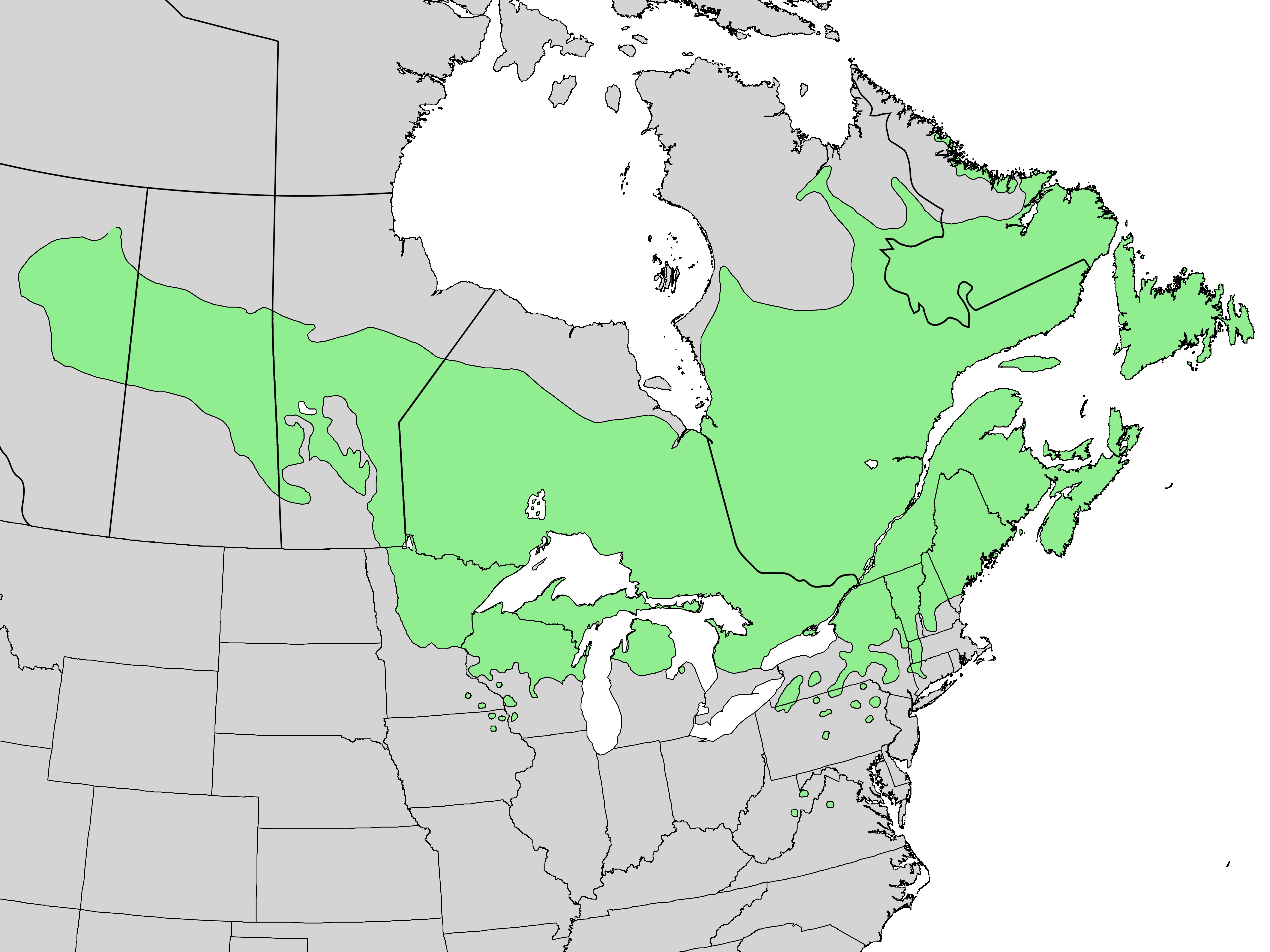
English: Distribution map for Abies balsamea (L.) Mill. - balsam fir |
| Dátum | |
| Forrás | USGS Geosciences and Environmental Change Science Center, Digital Representations of Tree Species Range Maps from "Atlas of United States Trees" by Elbert L. Little, Jr. (and other publications) |
| Szerző | Elbert L. Little, Jr., U.S. Department of Agriculture, Forest Service, and others |
Licenc
This image is in the public domain in the United States because it only contains materials that originally came from the United States Geological Survey, an agency of the United States Department of the Interior. For more information, see the official USGS copyright policy.
|
Fájltörténet
Kattints egy időpontra, hogy a fájl akkori állapotát láthasd.
| Dátum/idő | Bélyegkép | Felbontás | Feltöltő | Megjegyzés | |
|---|---|---|---|---|---|
| aktuális | 2013. december 14., 22:02 | | 5 926 × 4 445 (456 KB) | Nonenmac | higher-res, province borders, lakes white |
| 2013. március 20., 16:27 |  | 2 974 × 1 983 (109 KB) | Nonenmac | User created page with UploadWizard |
Fájlhasználat
Az alábbi lap használja ezt a fájlt:
Globális fájlhasználat
A következő wikik használják ezt a fájlt:
- Használata itt: arz.wikipedia.org
- Használata itt: ast.wikipedia.org
- Használata itt: be.wikipedia.org
- Használata itt: bg.wikipedia.org
- Használata itt: ca.wikipedia.org
- Használata itt: ceb.wikipedia.org
- Használata itt: cs.wikipedia.org
- Használata itt: de.wikipedia.org
- Használata itt: el.wikipedia.org
- Használata itt: en.wikipedia.org
- Használata itt: eo.wikipedia.org
- Használata itt: es.wikipedia.org
- Használata itt: et.wikipedia.org
- Használata itt: eu.wikipedia.org
- Használata itt: fa.wikipedia.org
- Használata itt: fr.wikipedia.org
- Használata itt: he.wikipedia.org
- Használata itt: hr.wikipedia.org
- Használata itt: hy.wikipedia.org
- Használata itt: is.wikipedia.org
- Használata itt: it.wikipedia.org
- Használata itt: koi.wikipedia.org
- Használata itt: lt.wikipedia.org
- Használata itt: nl.wikipedia.org
- Használata itt: no.wikipedia.org
- Használata itt: oc.wikipedia.org
- Használata itt: ro.wikipedia.org
- Használata itt: ru.wikipedia.org
- Használata itt: sl.wikipedia.org
- Használata itt: sv.wikipedia.org
- Használata itt: udm.wikipedia.org
- Használata itt: uk.wikipedia.org
- Használata itt: www.wikidata.org
- Használata itt: zh.wikipedia.org