Fájl:Arizona Congressional Districts, 113th Congress.tif

Ennek a(z) TIF fájlnak ezen JPG formátumú előnézete: 509 × 599 képpont. További felbontások: 204 × 240 képpont | 408 × 480 képpont | 652 × 768 képpont | 870 × 1 024 képpont | 1 288 × 1 516 képpont.
Eredeti fájl (1 288 × 1 516 képpont, fájlméret: 298 KB, MIME-típus: image/tiff)
|
Ez a fájl a Wikimedia Commonsból származik. Az alább látható leírás az ottani dokumentációjának másolata. A Commons projekt szabad licencű kép- és multimédiatár. Segíts te is az építésében! |
Összefoglaló
| Leírás |
English: Map of Congressional Districts in the state of Arizona, reflecting district boundaries current to the 113th United States Congress. |
| Dátum | |
| Forrás | National Atlas of the United States |
| Szerző | Department of the Interior |
Licenc
This map was obtained from an edition of the National Atlas of the United States. Like almost all works of the U.S. federal government, works from the National Atlas are in the public domain in the United States.
Online access: NationalAtlas.gov | 1970 print edition: Library of Congress, Perry-Castañeda Library
|
Fájltörténet
Kattints egy időpontra, hogy a fájl akkori állapotát láthasd.
| Dátum/idő | Bélyegkép | Felbontás | Feltöltő | Megjegyzés | |
|---|---|---|---|---|---|
| aktuális | 2014. február 1., 00:02 | 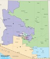 | 1 288 × 1 516 (298 KB) | 7partparadigm | User created page with UploadWizard |
Fájlhasználat
Az alábbi lap használja ezt a fájlt:
Globális fájlhasználat
A következő wikik használják ezt a fájlt:
- Használata itt: fa.wikipedia.org
- Használata itt: fr.wikipedia.org
- Használata itt: ru.wikipedia.org
- Használata itt: simple.wikipedia.org
- Használata itt: uk.wikipedia.org
- Használata itt: zh.wikipedia.org