Fájl:Baghdad etm 2003092 lrg.jpg

Eredeti fájl (889 × 1 200 képpont, fájlméret: 458 KB, MIME-típus: image/jpeg)
|
Ez a fájl a Wikimedia Commonsból származik. Az alább látható leírás az ottani dokumentációjának másolata. A Commons projekt szabad licencű kép- és multimédiatár. Segíts te is az építésében! |
| Leírás |
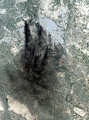
This image shows the city of Baghdad, the capital of Iraq. The dark smoke plumes are from pits of burning oil arrayed in a ring around the center of the city, a tactic used to stall and confuse invaders since medieval times. This picture is computer animated to show how it could look in reality. Baghdad Airport can be seen southwest of the city, just outside the smoke. This image was acquired by Landsat 7's Enhanced Thematic Mapper Plus (ETM+) sensor on April 2, 2003. |
|||||
| Dátum | Image taken on April 2, 2003. | |||||
| Forrás | http://earthobservatory.nasa.gov/NaturalHazards/natural_hazards_v2.php3?img_id=10149 | |||||
| Szerző | Image provided by the USGS EROS Data Center Satellite Systems Branch. | |||||
| Engedély (Fájl újrafelhasználása) |
|

Fájltörténet
Kattints egy időpontra, hogy a fájl akkori állapotát láthasd.
| Dátum/idő | Bélyegkép | Felbontás | Feltöltő | Megjegyzés | |
|---|---|---|---|---|---|
| aktuális | 2006. január 9., 07:58 | | 889 × 1 200 (458 KB) | Slarre~commonswiki | This image shows the city of Baghdad, the capital of Iraq. The dark smoke plumes are from pits of burning oil arrayed in a ring around the center of the city, a tactic used to stall and confuse invaders since medieval times. Baghdad Airport can be seen so |
Fájlhasználat
Ezt a fájlt nem használja egyetlen lap sem.
Globális fájlhasználat
A következő wikik használják ezt a fájlt:
- Használata itt: bg.wikipedia.org
- Használata itt: ca.wikipedia.org
- Használata itt: cs.wikipedia.org
- Használata itt: cy.wikipedia.org
- Használata itt: da.wikipedia.org
- Használata itt: de.wikipedia.org
- Használata itt: en.wikipedia.org
- Használata itt: en.wikiquote.org
- Használata itt: es.wikipedia.org
- Használata itt: fi.wikipedia.org
- Használata itt: fr.wikipedia.org
- Használata itt: he.wikipedia.org
- Használata itt: ko.wikipedia.org
- Használata itt: no.wikipedia.org
- Használata itt: pt.wikipedia.org
- Használata itt: ru.wikipedia.org
- Használata itt: sv.wikipedia.org
- Használata itt: tr.wikipedia.org
- Használata itt: uk.wikipedia.org
- Használata itt: vi.wikipedia.org
- Használata itt: zh-classical.wikipedia.org
- Használata itt: zh.wikipedia.org