Fájl:Bazentin le Petit 14 July 1916 map.png

Eredeti fájl (1 000 × 632 képpont, fájlméret: 113 KB, MIME-típus: image/png)
|
Ez a fájl a Wikimedia Commonsból származik. Az alább látható leírás az ottani dokumentációjának másolata. A Commons projekt szabad licencű kép- és multimédiatár. Segíts te is az építésében! |
Összefoglaló
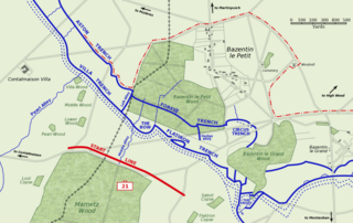
Map of Bazentin le Petit sector on the morning of 14 July 1916, Battle of Bazentin Ridge, showing the German second defensive position.
German trenches are shown in blue, including the communications trenches connecting to the (captured) first position. German barbed wire is shown as dotted blue lines. The start line of the assault brigades of the British 21st Division is shown in red. The position reached by the 21st Division and neighbouring 7th Division at 9 am is shown as the dashed red line.
Based on a trench map from the British Public Record Office.
| Gsl, a mű szerzője művét közkinccsé nyilvánította. Ez a világ minden részén érvényes. Egyes országokban ez jogilag nem lehetséges. Ha így van, akkor: |
Fájltörténet
Kattints egy időpontra, hogy a fájl akkori állapotát láthasd.
| Dátum/idő | Bélyegkép | Felbontás | Feltöltő | Megjegyzés | |
|---|---|---|---|---|---|
| aktuális | 2005. október 21., 12:38 | | 1 000 × 632 (113 KB) | Igiveup | Map of Bazentin le Petit sector on the morning of 14 July 1916, Battle of Bazentin Ridge, showing the German second defensive position. German trenches are shown in blue, including the communications trenches connecting to the (captured) first position. |
Fájlhasználat
Az alábbi lap használja ezt a fájlt:
Globális fájlhasználat
A következő wikik használják ezt a fájlt:
- Használata itt: af.wikipedia.org
- Használata itt: azb.wikipedia.org
- Használata itt: ca.wikipedia.org
- Használata itt: el.wikipedia.org
- Használata itt: en.wikipedia.org
- Használata itt: es.wikipedia.org
- Használata itt: fr.wikipedia.org
- Használata itt: id.wikipedia.org
- Használata itt: it.wikipedia.org
- Használata itt: lt.wikipedia.org
- Használata itt: no.wikipedia.org