Fájl:Bougainville Operation map.jpg

Eredeti fájl (562 × 798 képpont, fájlméret: 158 KB, MIME-típus: image/jpeg)
|
Ez a fájl a Wikimedia Commonsból származik. Az alább látható leírás az ottani dokumentációjának másolata. A Commons projekt szabad licencű kép- és multimédiatár. Segíts te is az építésében! |
Összefoglaló
| Leírás |
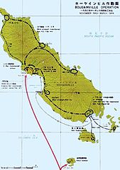
English: Map of Japanese troop movements on Bougainville during the fighting on the island between November 1943 and March 1944 |
| Dátum | Created in or prior to 1950, first published in 1966 |
| Forrás | Reports of General MacArthur: JAPANESE OPERATIONS IN THE SOUTHWEST PACIFIC AREA. VOLUME II - PART I. Archiválva az eredetiből ekkor: 2016. március 4.. Elérés 2012. április 9.. |
| Szerző | Not stated. The materials were provided to the US Army by the Japanese Demobilization Bureaux. The book was commissioned and published by the US Army |
Licenc
| According to Japanese Copyright Law (June 1, 2018 grant), the work is now in the public domain in Japan because the copyrights of the works in names of organizations, in Japan expire in 50 years after the publication, or in 50 years after the creation if the works are not published within 50 years after the creation (article 53).
To uploader: Please provide a name of organization and year of publication and source.
Note: The enforcement of the revised Copyright Act on December 30, 2018 extended the copyright term of works whose copyright was valid on that day to 70 years. Do not use this template for works published after 1967. Please note that being in the public domain in Japan does not automatically mean that it is free as well in the United States. Find and add one of the PD US license tags in order to ensure that the file is free in the United States. Typically, for a published work to be in the public domain in the United States, it needs to be published before 1946, because of URAA-restored copyrights. Unpublished works need to satisfy {{PD-US-unpublished}}.
|

|
Fájltörténet
Kattints egy időpontra, hogy a fájl akkori állapotát láthasd.
| Dátum/idő | Bélyegkép | Felbontás | Feltöltő | Megjegyzés | |
|---|---|---|---|---|---|
| aktuális | 2017. április 1., 17:31 | | 562 × 798 (158 KB) | Hohum | Reverted to version as of 15:26, 1 April 2017 (UTC) |
| 2017. április 1., 17:27 |  | 562 × 798 (155 KB) | Hohum | Slightly brighter | |
| 2017. április 1., 17:26 |  | 562 × 798 (158 KB) | Hohum | Reworked colours | |
| 2016. május 19., 17:09 |  | 562 × 798 (152 KB) | Hohum | Cleanup | |
| 2012. április 9., 03:48 |  | 562 × 798 (98 KB) | Nick-D | {{Information |Description ={{en|1=Map of Japanese troop movements on Bougainville during the fighting on the island between November 1943 and March 1944}} |Source =http://www.history.army.mil/books/wwii/MacArthur%20Reports/MacArthur%20V2%20... |
Fájlhasználat
Az alábbi lap használja ezt a fájlt:
Globális fájlhasználat
A következő wikik használják ezt a fájlt:
- Használata itt: de.wikipedia.org
- Használata itt: en.wikipedia.org
- Használata itt: fr.wikipedia.org
- Használata itt: ru.wikipedia.org