Fájl:C71072s1 Ant.Map Beethoven Peninsula.jpg
Az előnézet mérete: 600 × 600 képpont További felbontások: 240 × 240 képpont | 480 × 480 képpont | 768 × 768 képpont | 1 024 × 1 024 képpont | 2 048 × 2 048 képpont | 3 104 × 3 104 képpont.
Eredeti fájl (3 104 × 3 104 képpont, fájlméret: 1,25 MB, MIME-típus: image/jpeg)
|
Ez a fájl a Wikimedia Commonsból származik. Az alább látható leírás az ottani dokumentációjának másolata. A Commons projekt szabad licencű kép- és multimédiatár. Segíts te is az építésében! |
Összefoglaló
| Leírás |
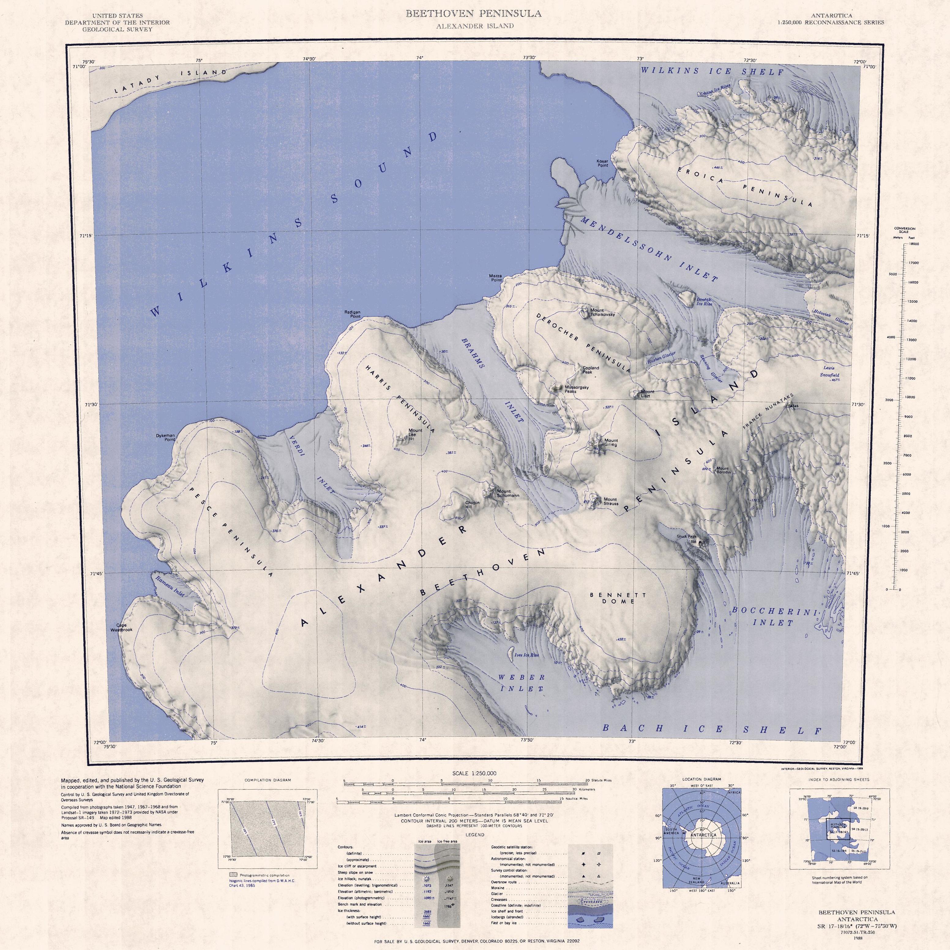
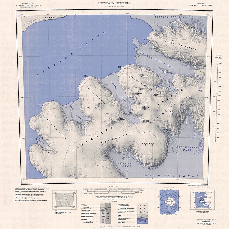
English: 1:250,000-scale topographic reconnaissance map of the Beethoven Peninsula area of Alexander Island from 72°-75°30'W to 71°-72°S in Antarctica. Mapped, edited and published by the U.S. Geological Survey in cooperation with the National Science Foundation. |
|||
| Dátum | ||||
| Forrás | http://usarc.usgs.gov/drg_dload.shtml | |||
| Szerző | United States Geological Survey | |||
| Engedély (Fájl újrafelhasználása) |
|
Fájltörténet
Kattints egy időpontra, hogy a fájl akkori állapotát láthasd.
| Dátum/idő | Bélyegkép | Felbontás | Feltöltő | Megjegyzés | |
|---|---|---|---|---|---|
| aktuális | 2021. november 3., 05:53 | | 3 104 × 3 104 (1,25 MB) | User-duck | Cropped and rotated using CropTool with precise mode. |
| 2005. április 3., 18:02 |  | 3 797 × 3 188 (1,53 MB) | Achim Raschka | Map of Antarctica by the United States Antarctic Ressource Center of the US Geological Society. {{PD-US}} Copyrights and Trademarks USGS-authored or produced data and information are in the public domain. While the content of most USGS web pages is in th |
Fájlhasználat
Az alábbi lapok használják ezt a fájlt:
Globális fájlhasználat
A következő wikik használják ezt a fájlt:
- Használata itt: bg.wikipedia.org
- Használata itt: ceb.wikipedia.org
- Használata itt: de.wikipedia.org
- Alexander-I.-Insel
- Boccherini Inlet
- Beethoven-Halbinsel
- Bennett Dome
- Weber Inlet
- Brahms Inlet
- Harris-Halbinsel
- Derocher-Halbinsel
- Verdi Inlet
- Mount Lee (Alexander-I.-Insel)
- Mendelssohn Inlet
- Pesce-Halbinsel
- Eroica-Halbinsel
- Rameau Inlet
- Kap Westbrook
- Chopin Hill
- Mount Schumann
- Copland Peak
- Mussorgsky Peaks
- Mount Grieg
- Dvořák Ice Rise
- Dykeman Point
- Rameau-Schelfeis
- Verdi-Schelfeis
- Mount Liszt
- Mount Strauss
- Mount Tchaikovsky
- Franck-Nunatakker
- Kosar Point
- Mazza Point
- Radigan Point
- Bach Inlet
- Mendelssohn-Schelfeis
- Használata itt: en.wikipedia.org
A fájl globális használatának megtekintése