Fájl:Duchy of Prussia.svg

Ennek a(z) SVG fájlnak ezen PNG formátumú előnézete: 610 × 588 képpont. További felbontások: 249 × 240 képpont | 498 × 480 képpont | 797 × 768 képpont | 1 062 × 1 024 képpont | 2 125 × 2 048 képpont.
Eredeti fájl (SVG fájl, névlegesen 610 × 588 képpont, fájlméret: 55 KB)
|
Ez a fájl a Wikimedia Commonsból származik. Az alább látható leírás az ottani dokumentációjának másolata. A Commons projekt szabad licencű kép- és multimédiatár. Segíts te is az építésében! |
Összefoglaló
| Leírás |
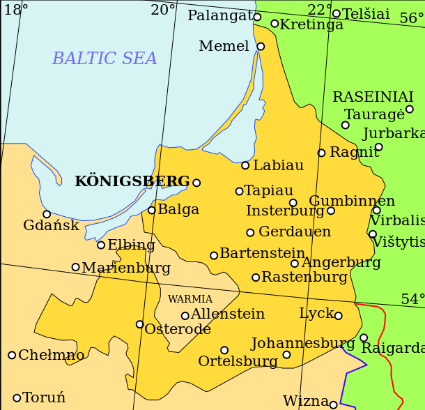
English: Map showing the Duchy of Prussia, at an indeterminable date. Place names inside the Duchy are given in German, as are Elbing and Marienburg. Other names are modern.
Territory of the Duchy of Prussia Territory of the Kingdom of Poland before the Union of Lublin Territory of the Grand Duchy of Lithuania before the Union of Lublin Polish-Lithuanian border before the Union of Lublin Polish-Lithuanian border after the Union of Lublin |
| Dátum | |
| Forrás | A feltöltő saját munkája, a következőn alapul: (litván nyelven) (2001) Lietuvos istorijos atlasas, Vilnius: Vaga, 16—17 o. |
| Szerző | Grandiose |
| Más változatok |
|
| SVG kód | Ez vektorgrafikus kép Inkscape segítségével készült. |

| File | Type | Details |
|---|---|---|
| File:Polish-Lithuania map (1450-1600).svg | Large SVG | Map showing conflicts and territorial changes on the Polish-Lithuanian—Russian border, 1450–1600 |
| File:Duchy of Prussia.svg | Small SVG | Map of the Duchy of Prussia |
| File:Livonian war map (1558-1560).svg | Small SVG | Map showing campaigns in Livonia, 1558–1560. |
| File:Map of Poland and Lithuania after the Union of Lublin (1569).svg | Large SVG | Map of the w:Polish-Lithuanian Commonwealth after the Union of Lublin in 1569. |
| File:Livonian war map (1570-1577).svg | Small SVG | Map showing areas of Russian and Polish-Lithuanian forces, 1570–1577. |
| File:Campaigns of Stefan Batory.svg | Small SVG | Map of the campaign of Stefan Batory in Livonia (1575–1580). |
| File:Map of Poland and Lithuania in 1600.svg | Small SVG | Map of Livonia in 1600 |
| See also: User:Halibutt/maps, by Halibutt (vitalap · szerkesztései). | ||
.svg)
.svg)
.svg)
.svg)
Licenc
Én, e mű szerzője a művemet az alábbi licenc alatt teszem közzé:
Ez a fájl a Creative Commons Nevezd meg! – Így add tovább! 3.0 Unported licenc alapján használható fel.
- A következőket teheted a művel:
- megoszthatod – szabadon másolhatod, terjesztheted, bemutathatod és előadhatod a művet
- feldolgozhatod – származékos műveket hozhatsz létre
- Az alábbi feltételekkel:
- Nevezd meg! – A szerzőt megfelelően fel kell tüntetned, hivatkozást kell létrehoznod a licencre és jelezned kell, ha a művön változtatást hajtottál végre. Ezt bármilyen észszerű módon megteheted, kivéve oly módon, ami azt sugallná hogy a jogosult támogat téged vagy a felhasználásod körülményeit.
- Így add tovább! – Ha megváltoztatod, átalakítod, feldolgozod ezt a művet, a közreműködésedet csak az eredetivel megegyező vagy hasonló licenc alatt terjesztheted.
Fájltörténet
Kattints egy időpontra, hogy a fájl akkori állapotát láthasd.
| Dátum/idő | Bélyegkép | Felbontás | Feltöltő | Megjegyzés | |
|---|---|---|---|---|---|
| aktuális | 2011. április 20., 12:07 | | 610 × 588 (55 KB) | Grandiose | Correct spelling |
| 2011. április 19., 14:44 |  | 610 × 588 (54 KB) | Grandiose | Lines on longitude and latitude; other important fixes. | |
| 2011. április 19., 14:36 |  | 610 × 588 (1,1 MB) | Grandiose | Fix text locations | |
| 2011. április 19., 14:33 |  | 610 × 588 (1,1 MB) | Grandiose |
Fájlhasználat
Az alábbi lap használja ezt a fájlt:
Globális fájlhasználat
A következő wikik használják ezt a fájlt:
- Használata itt: ar.wikipedia.org
- Használata itt: ast.wikipedia.org
- Használata itt: br.wikipedia.org
- Használata itt: ca.wikipedia.org
- Használata itt: cs.wikipedia.org
- Használata itt: de.wikipedia.org
- Használata itt: el.wikipedia.org
- Használata itt: en.wikipedia.org
- Használata itt: eu.wikipedia.org
- Használata itt: fa.wikipedia.org
- Használata itt: fi.wikipedia.org
- Használata itt: gl.wikipedia.org
- Használata itt: he.wikipedia.org
- Használata itt: hr.wikipedia.org
- Használata itt: is.wikipedia.org
- Használata itt: it.wikipedia.org
- Használata itt: ja.wikipedia.org
- Használata itt: ko.wikipedia.org
- Használata itt: lt.wikipedia.org
- Használata itt: mk.wikipedia.org
- Használata itt: rue.wikipedia.org
- Használata itt: ru.wikipedia.org
- Használata itt: sc.wikipedia.org
- Használata itt: sh.wikipedia.org
- Használata itt: sv.wikipedia.org
- Használata itt: th.wikipedia.org
- Használata itt: tr.wikipedia.org
- Használata itt: uk.wikipedia.org
- Használata itt: vi.wikipedia.org
- Használata itt: www.wikidata.org
- Használata itt: zh.wikipedia.org