Fájl:Iberian Peninsula in 125-en.svg

Eredeti fájl (SVG fájl, névlegesen 720 × 576 képpont, fájlméret: 1,07 MB)
|
Ez a fájl a Wikimedia Commonsból származik. Az alább látható leírás az ottani dokumentációjának másolata. A Commons projekt szabad licencű kép- és multimédiatár. Segíts te is az építésében! |
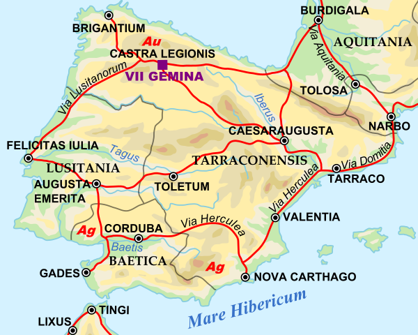
| Leírás | Shows Iberian peninsula in 125 including important roads, legionnaire locations and gold/silver mines. "NOTE: Barbarian names and locations as in the works of Tacitus (written ca. 100 AD)" |
| Dátum | |
| Forrás | |
| Szerző |
|
| Más változatok |
[]
|


SVG Support
This document is in the Scalable Vector Graphic format (SVG) and requires a supported browser (Firefox, Google Chrome, Opera) or a SVG plugin for Internet Explorer and other browsers. SVG is an open source format, which means this map can be downloaded and modified/translated completely using a vector graphics editor like Adobe Illustrator or Inkscape (free) or a text editor such as Notepad.
| BLANK THUMBNAIL | View large PNG | View medium PNG | SVG Plugin for Internet Explorer and other browsers |
|---|---|---|---|
| Click here (purge cache) and then CTRL+F5 to reload. Help? | Try 1 Try 2 | Try 1 Try 2 | Adobe SVG plugin |
| Recommended browser | More Help | ||
| Firefox | List of SVG tools |
| Ez egy retusált kép, ami azt jelenti, hogy az eredetihez képest digitálisan módosították. Módosítások: Zoomed in to Iberian peninsula. Az eredeti itt található: Roman Empire 125.svg.
|
| Én, a szerző, ezt a művemet ezennel közkinccsé nyilvánítom. Ez a világ minden részén érvényes. Egyes országokban ez jogilag nem lehetséges. Ha így van, akkor: Jogot adok bárkinek, hogy bármilyen célból, feltétel nélkül használhassa ezt a fájlt, kivéve a törvény által kötelezően előírt feltételeket. |
Eredeti feltöltési napló
This image is a derivative work of the following images:
- File:Roman_Empire_125.svg licensed with PD-user-en, PD-user-w, PD-user-w/de
Uploaded with derivativeFX
Fájltörténet
Kattints egy időpontra, hogy a fájl akkori állapotát láthasd.
| Dátum/idő | Bélyegkép | Felbontás | Feltöltő | Megjegyzés | |
|---|---|---|---|---|---|
| aktuális | 2009. április 29., 12:45 | | 720 × 576 (1,07 MB) | ArdadN | update2 |
| 2009. április 29., 12:40 |  | 720 × 576 (1,07 MB) | ArdadN | update | |
| 2009. március 28., 22:21 |  | 720 × 576 (1,07 MB) | Malus Catulus | {{Information |Description=Shows Iberian peninsula in 125 including important roads, legionnaire locations and gold/silver mines. "NOTE: Barbarian names and locations as in the works of Tacitus (written ca. 100 AD)" |Source=*[[:File:Roman_Empire_125.svg| |
Fájlhasználat
Az alábbi lap használja ezt a fájlt:
Globális fájlhasználat
A következő wikik használják ezt a fájlt:
- Használata itt: arz.wikipedia.org
- Használata itt: ast.wikipedia.org
- Használata itt: bg.wikipedia.org
- Használata itt: bs.wikipedia.org
- Használata itt: el.wikipedia.org
- Használata itt: en.wikipedia.org
- Használata itt: es.wikipedia.org
- Használata itt: et.wikipedia.org
- Használata itt: eu.wikipedia.org
- Használata itt: fi.wikipedia.org
- Használata itt: fr.wikipedia.org
- Használata itt: hr.wikipedia.org
- Használata itt: hy.wikipedia.org
- Használata itt: it.wikipedia.org
- Használata itt: ja.wikipedia.org
- Használata itt: ko.wikipedia.org
- Használata itt: la.wikipedia.org
- Használata itt: lv.wikipedia.org
- Használata itt: nl.wikipedia.org
- Használata itt: pt.wikiversity.org
- Használata itt: ru.wikipedia.org
- Használata itt: sh.wikipedia.org
- Használata itt: sl.wikipedia.org
- Használata itt: sv.wikipedia.org
- Használata itt: th.wikipedia.org
A fájl globális használatának megtekintése