Fájl:Joshua tree national-park map.jpg

Az előnézet mérete: 800 × 386 képpont További felbontások: 320 × 154 képpont | 640 × 309 képpont | 1 024 × 494 képpont | 1 280 × 617 képpont | 2 560 × 1 235 képpont | 6 774 × 3 267 képpont.
Eredeti fájl (6 774 × 3 267 képpont, fájlméret: 1,64 MB, MIME-típus: image/jpeg)
|
Ez a fájl a Wikimedia Commonsból származik. Az alább látható leírás az ottani dokumentációjának másolata. A Commons projekt szabad licencű kép- és multimédiatár. Segíts te is az építésében! |
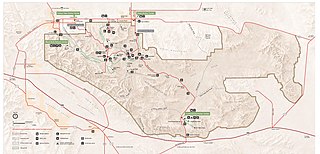
| Leírás | Map of Joshua Tree National Park — in the Mojave Desert, eastern Southern California. |
| Dátum | downloaded 2012-01 |
| Forrás | http://www.nps.gov/jotr/planyourvisit/upload/jotrmap.pdf |
| Szerző | National Park Service |
| Engedély (Fájl újrafelhasználása) |
PD-USGov-NPS |
| This image or media file contains material based on a work of a National Park Service employee, created as part of that person's official duties. As a work of the U.S. federal government, such work is in the public domain in the United States. See the NPS website and NPS copyright policy for more information. |
Fájltörténet
Kattints egy időpontra, hogy a fájl akkori állapotát láthasd.
| Dátum/idő | Bélyegkép | Felbontás | Feltöltő | Megjegyzés | |
|---|---|---|---|---|---|
| aktuális | 2012. január 6., 06:02 | | 6 774 × 3 267 (1,64 MB) | Jarekt | Updated 2011 version from http://www.nps.gov/jotr/planyourvisit/upload/jotrmap.pdf |
| 2006. március 27., 08:49 |  | 1 245 × 593 (563 KB) | Huebi~commonswiki | {{PD-USGov-NPS}} |
Fájlhasználat
Az alábbi lap használja ezt a fájlt:
Globális fájlhasználat
A következő wikik használják ezt a fájlt:
- Használata itt: de.wikipedia.org
- Használata itt: de.wikivoyage.org
- Használata itt: eo.wikipedia.org
- Használata itt: es.wikipedia.org
- Használata itt: eu.wikipedia.org
- Használata itt: he.wikipedia.org
- Használata itt: pl.wikipedia.org
- Használata itt: pt.wikipedia.org
- Használata itt: tr.wikipedia.org