Fájl:Kamianets-Podilskyi map 1691.jpg

Eredeti fájl (2 296 × 1 680 képpont, fájlméret: 1,58 MB, MIME-típus: image/jpeg)
|
Ez a fájl a Wikimedia Commonsból származik. Az alább látható leírás az ottani dokumentációjának másolata. A Commons projekt szabad licencű kép- és multimédiatár. Segíts te is az építésében! |
Összefoglaló
| Leírás |
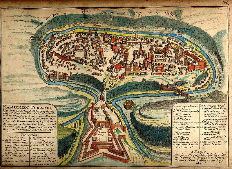
Українська: Давня французька мапа Кам'янця-Подільського 1691 після його захоплення турками
Русский: Старинная карта Каменца-Подольского 1691 года. |
||||||||||||||||||||
| Map legend |
Français : KAMIENIEC PODOLSKI Ville forte des Estats de Pologne, et de la Haute Podolie avec Titre d'Evéché et de Palatinat, située sur le Sommet d’une Montagne entourée de la Riviere de Smotrycz, et envelopée de Rochers escarpez, à 48. degrez 45. minutes de Latitude et 50. deg. 10. min. de Longitude. Cette Place fut prise par les Turcs sur Polonais le 29e Aoust 1672. Renvois
A PARIS |
||||||||||||||||||||
| Dátum | |||||||||||||||||||||
| Forrás | brooks-planck.org | ||||||||||||||||||||
| Alkotó |
|
||||||||||||||||||||
| Georeferencing | If inappropriate please set warp_status = skip to hide. | ||||||||||||||||||||

Fortified city of the Polish State and of Upper Podolia, with the title of bishopric and palatinate [voivodeship], situated on top of a mountain surrounded by the Smotrycz River and enclosed by steep rocks, at 48°45’ latitude and 50°10’ longitude. This place was taken by the Turks from the Poles on 29 August 1672.
References
- Lech’s Palace
- Cathedral church of St Peter and St Paul, today the main mosque where the Grand Vizier entered on 3 September 1672
- St Nicholas’ [church] of the Dominicans
- Franciscan monastery
- Jesuits’ [church], now a stable
- Discalced Carmelites’ [church]
- St Catherine’s [church], now a stable
- Jesuits’ [church] of St Michael where the janissaries are quartered
- St Lazarus Hospital
- St Peter’s and St Paul’s [church], previously Ruthenian [Orthodox], today Catholic
- St Stanislaus’ [church] in the fortress
- Our Lady’s [church]
- St Nicholas’ [church]
- Armenian [Orthodox] church
- Holy Trinity [church]
- St John’s [church, now] Grand Vizier’s mosque
- Ascension [church]
- St Nicholas’ [church]
- St Mary’s [church]
- St Michael’s [church]
- Nativity [church]
- Holy Cross [church] outside the fortress
- St George’s [church], burnt
- Ruins of a tower which collapsed on the eve of the city’s capture, where 600 people perished
- Bridge linking the city with the fortress
- Canal linking the inlet and the outlet of the river
- [Place] where the Turks entered the moat
- Place where the Turks planted a mine
[Made] in Paris
At Mr. [Nicolas] De Fer’s [workshop] on the Palace Island on the Clock Quay at the Royal Sphere. With royal privilege, 1691.
Full text of the legend
| Képjegyzetek | Ehhez a képhez képjegyzetek tartoznak: Képjegyzetek megtekintése a Commonson |
Licenc
|
Ez a mű közkincs abban az országban, ahol elkészítették, és minden olyan további államban, ahol a szerzői jogi védelmi idő a szerző élete plusz 100 év vagy kevesebb. | |
| Megállapították, hogy ez a fájl mentes mindenféle szerzői jogi korlátozástól, beleértve az összes kapcsolódó és hozzátartozó jogot. | |
Assessment
|

Fájltörténet
Kattints egy időpontra, hogy a fájl akkori állapotát láthasd.
| Dátum/idő | Bélyegkép | Felbontás | Feltöltő | Megjegyzés | |
|---|---|---|---|---|---|
| aktuális | 2007. október 19., 01:29 | | 2 296 × 1 680 (1,58 MB) | DDima | {{Information |Description={{en|An 1691 map of the Ukrainian City of Kamianets-Podilskyi.}} {{ru|Старинная карта Каменца-Подольского 1691 года}} |Source=[[:ru:Изображени |
Fájlhasználat
Az alábbi lap használja ezt a fájlt:
Globális fájlhasználat
A következő wikik használják ezt a fájlt:
- Használata itt: ast.wikipedia.org
- Használata itt: az.wikipedia.org
- Használata itt: be.wikipedia.org
- Használata itt: bg.wikipedia.org
- Használata itt: ca.wikipedia.org
- Használata itt: de.wikipedia.org
- Használata itt: dsb.wikipedia.org
- Használata itt: el.wikipedia.org
- Használata itt: en.wikipedia.org
- Wikipedia:WikiProject Former countries
- Podolian Voivodeship
- Kamianets-Podilskyi
- Portal:Ukraine
- Portal:Ukraine/Featured picture
- Portal talk:Ukraine/Featured picture
- Wikipedia:WikiProject Poland
- User:Sashazlv/Try
- Portal:History/Featured picture
- Wikipedia:WikiProject Urban studies and planning
- Portal:Maps/Selected picture
- Wikipedia:Featured pictures thumbs/08
- Wikipedia:WikiProject Ukraine
- User talk:DDima/Archive 3
- Wikipedia:Featured picture candidates/Kamianets-Podilskyi map
- Wikipedia:Wikipedia Signpost/2007-11-05/Features and admins
- Wikipedia:Featured picture candidates/November-2007
- Portal:Maps/Selected picture/30
- Wikipedia:Picture of the day/March 2008
- Kamianets-Podilskyi Castle
- Template:POTD/2008-03-09
- Wikipedia:Featured pictures/Diagrams, drawings, and maps/Maps
- Portal:Russia/Selected picture/11
- Wikipedia:Wikipedia Signpost/2007-11-05/SPV
- Podolia Eyalet
- Royal city in Polish–Lithuanian Commonwealth
- Portal:Poland/Recognized content
- Portal:Ukraine/Recognized content
- Wikipedia:WikiProject Former countries/Recognized content
- Wikipedia:Wikipedia Signpost/Single/2007-11-05
- Használata itt: en.wikivoyage.org
- Használata itt: es.wikipedia.org
- Használata itt: fr.wikipedia.org
A fájl globális használatának megtekintése