Fájl:Kiplingsindia.jpg

Eredeti fájl (802 × 663 képpont, fájlméret: 114 KB, MIME-típus: image/jpeg)
|
Ez a fájl a Wikimedia Commonsból származik. Az alább látható leírás az ottani dokumentációjának másolata. A Commons projekt szabad licencű kép- és multimédiatár. Segíts te is az építésében! |
Összefoglaló
| Leírás |
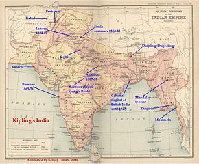
ÖsszefoglalóThis is a low-resolution (40% of original) scanned image of the map, "Politial Divisions of the Indian Empire" from the Imperial Gazeteer of India (volume 26, Atlas), published by the Oxford University Press, 1909. The map image was scanned and then annotated by me (Sanjay Tiwari 18:24, 30 September 2006 (UTC)) |
||||||
| Forrás | A feltöltő saját munkája | ||||||
| Szerző | User Sanjay Tiwari on en.wikipedia | ||||||
| Engedély (Fájl újrafelhasználása) |
|
||||||
| Más változatok |
Originally from en.wikipedia; description page is (was) here * 18:24, 30 September 2006 [[:en:User:Sanjay Tiwari|Sanjay Tiwari]] 880×680 (126,459 bytes) <span class="comment">(This is a low-resolution (40% of original) scanned image of the map, "Politial Divisions of the Indian Empire" from the ''Imperial Gazeteer of India'' (volume 26, Atlas), published by the Oxford University Press, 1909. The map image was scanned and the)</span> |
||||||
(Uploaded using CommonsHelper or PushForCommons)
Licenc
|
Ez a mű közkincs abban az országban, ahol elkészítették, és minden olyan további államban, ahol a szerzői jogi védelmi idő a szerző élete plusz 70 év vagy kevesebb.
| |
| Megállapították, hogy ez a fájl mentes mindenféle szerzői jogi korlátozástól, beleértve az összes kapcsolódó és hozzátartozó jogot. | |
Eredeti feltöltési napló
- 2007-05-14 07:25 Kintetsubuffalo 802×663× (117058 bytes) trimmed to make edges equal
- 2006-09-30 18:24 Sanjay Tiwari 880×680× (126459 bytes) This is a low-resolution (40% of original) scanned image of the map, "Politial Divisions of the Indian Empire" from the ''Imperial Gazeteer of India'' (volume 26, Atlas), published by the Oxford University Press, 1909. The map image was scanned and the
Fájltörténet
Kattints egy időpontra, hogy a fájl akkori állapotát láthasd.
| Dátum/idő | Bélyegkép | Felbontás | Feltöltő | Megjegyzés | |
|---|---|---|---|---|---|
| aktuális | 2016. március 28., 15:39 | | 802 × 663 (114 KB) | OgreBot | (BOT): Uploading old version of file from en.wikipedia; originally uploaded on 2007-05-14 07:25:05 by Kintetsubuffalo |
| 2016. március 28., 15:39 |  | 880 × 680 (123 KB) | OgreBot | (BOT): Uploading old version of file from en.wikipedia; originally uploaded on 2006-09-30 18:24:12 by Sanjay Tiwari | |
| 2006. november 13., 22:17 |  | 776 × 600 (95 KB) | Chechof | {{Information| |Description= == Summary == This is a low-resolution (40% of original) scanned image of the map, "Politial Divisions of the Indian Empire" from the ''Imperial Gazeteer of India'' (volume 26, Atlas), published by the Oxford University Press |
Fájlhasználat
Az alábbi lap használja ezt a fájlt:
Globális fájlhasználat
A következő wikik használják ezt a fájlt:
- Használata itt: ca.wikipedia.org
- Használata itt: el.wikipedia.org
- Használata itt: en.wikipedia.org
- Használata itt: es.wikipedia.org
- Használata itt: gl.wikipedia.org
- Használata itt: hi.wikipedia.org
- Használata itt: ja.wikipedia.org
- Használata itt: pt.wikipedia.org
- Használata itt: tt.wikipedia.org
- Használata itt: vi.wikipedia.org