Fájl:LA2-Bering-Sea-UTM-zones.png

Az előnézet mérete: 800 × 430 képpont További felbontások: 320 × 172 képpont | 640 × 344 képpont | 960 × 516 képpont.
Eredeti fájl (960 × 516 képpont, fájlméret: 103 KB, MIME-típus: image/png)
|
Ez a fájl a Wikimedia Commonsból származik. Az alább látható leírás az ottani dokumentációjának másolata. A Commons projekt szabad licencű kép- és multimédiatár. Segíts te is az építésében! |
Összefoglaló
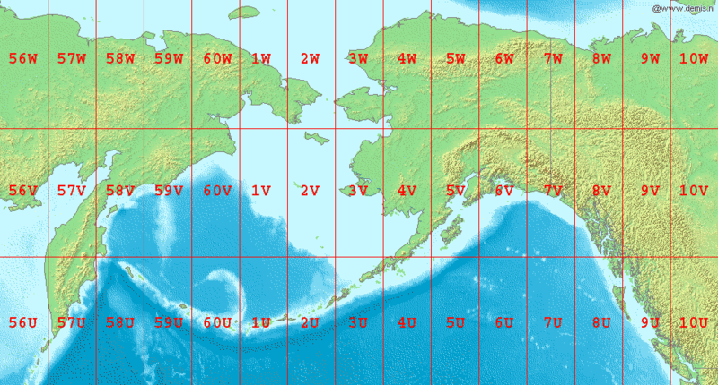
English: Map of en:Bering Sea, showing the latitude and longitude zones of the en:Universal Transverse Mercator coordinate system, from 56U to 10W.
National borders between Alaska, Canada, and the continental United States are also shown.
Bounding box West 150°, South 48°, East -120°, North 72°.
Center at 60°00′00″N 165°00′00″W / 60.00000°N 165.00000°W.
Licenc
This image is in the public domain because it came from the site https://www.demis.nl/products/web-map-server/examples/ and was released by the copyright holder. Permission is granted to copy, distribute and/or modify this map since it is based on free of copyright images from: www.demis.nl. See also approval email on de.wp and its clarification.
|
| This work has been released into the public domain by its copyright holder, www.demis.nl. This applies worldwide. Egyes országokban ez jogilag nem lehetséges. Ha így van, akkor: www.demis.nl jogot ad bárkinek, hogy bármilyen célból, feltétel nélkül használhassa ezt a fájlt, kivéve a törvény által kötelezően előírt feltételeket.
|
Fájltörténet
Kattints egy időpontra, hogy a fájl akkori állapotát láthasd.
| Dátum/idő | Bélyegkép | Felbontás | Feltöltő | Megjegyzés | |
|---|---|---|---|---|---|
| aktuális | 2006. szeptember 3., 09:04 | | 960 × 516 (103 KB) | LA2 | Map of en:Bering Sea, showing the latitude and longitude zones of the en:Universal Transverse Mercator coordinate system, from 56U to 10W. National borders between Alaska, Canada, and the continental United States are also shown. Bounding box W |
Fájlhasználat
Az alábbi lap használja ezt a fájlt:
Globális fájlhasználat
A következő wikik használják ezt a fájlt:
- Használata itt: ar.wikipedia.org
- Használata itt: ast.wikipedia.org
- Használata itt: da.wikipedia.org
- Használata itt: el.wikipedia.org
- Használata itt: en.wikipedia.org
- Használata itt: es.wikipedia.org
- Használata itt: fa.wikipedia.org
- Használata itt: gv.wikipedia.org
- Használata itt: hr.wikipedia.org
- Használata itt: id.wikipedia.org
- Használata itt: it.wikipedia.org
- Használata itt: kk.wikipedia.org
- Használata itt: la.wikipedia.org
- Használata itt: ml.wikipedia.org
- Használata itt: my.wikipedia.org
- Használata itt: nl.wikipedia.org
- Használata itt: nn.wikipedia.org
- Használata itt: pa.wikipedia.org
- Használata itt: pl.wikipedia.org
- Használata itt: sr.wikipedia.org
- Használata itt: ta.wikipedia.org
- Használata itt: th.wikipedia.org
- Használata itt: tr.wikipedia.org
- Használata itt: ur.wikipedia.org
- Használata itt: yi.wikipedia.org