Fájl:Lop Nur and the potash fertilizer production plant 2009.jpg

Eredeti fájl (2 472 × 1 624 képpont, fájlméret: 2,09 MB, MIME-típus: image/jpeg)
|
Ez a fájl a Wikimedia Commonsból származik. Az alább látható leírás az ottani dokumentációjának másolata. A Commons projekt szabad licencű kép- és multimédiatár. Segíts te is az építésében! |
| Leírás |
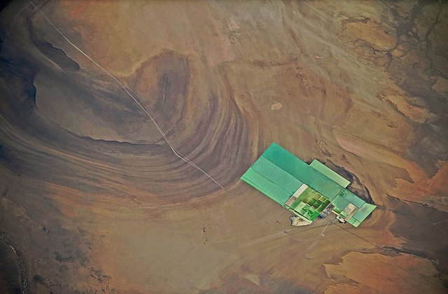
English: The satellite picture shows a part of the former See Lop Nur in the Lop Desert, Xinjiang, China, with a production plant to produce yearly 1.2 million tons potash fertilizer. You see at the left side a part of the „Big Ear“ of Lop Nur and in the right corner at the top the former delta of the Tarim river. The world's largest potash fertilizer production plant in the size 10 to 21 km and the area 164 km² is built in the former Lake Lop Nur, Xinjiang, China. The first phase of the project which has an annual capacity of 1.2 million tons was put into operation on Dec. 18, 2008. The second phase with another annual capacity of 1.7 million tons has been launched 2009 and will be operational in 2014. The 3 million program will make Lop Nor the largest potash fertilizer production base in the world. The Project of Development and Utilization of Sylvite Resources in Lop Nur region employs the technique of producing potassium sulphate through magnesium sulfate subtype brine, which filled a technological gas of this kind and made China among the fewer countries that could produce potassium sulphate from brine directly taken from salt lake. The north is at the right side of the image. The satellite picture is taken 2009-10-12. For more informatiom see here, here
and here.
Deutsch: Das Satellitenbild zeigt das ausgetrocknete Seebecken Lop Nor in Xinjiang, China, mit dem 2008 fertiggestellten 21 km langen und 10 km breiten und 164 km² großen Kaliumchloridwerk, in dem Pottasche-Dünger hergestellt wird. Außerdem erkennt man links im Bild den oberen Teil einer Helix in Form einer Ohrmuschel mit konzentrischen Kreisen und in der rechten oberen Ecke das ehemalige Delta des Tarim. In dem Seebecken Lop Nor befindet sich eine sedimentäre Salzlagerstätte von sylvinitischem Kalisalz für die Herstellung von Pottasche, die das größte Vorkommen von Sylvin in China enthält. Sie verfügt über 240 Millionen Tonnen Kaliumchlorid und hat insgesamt geschätzte Reserven von 500 Millionen Tonnen Kalisalz. Die bestätigten Vorkommen befinden sich in einem Gebiet, das sich 60,5 km von Nord nach Süd und 32,5 km von Ost nach West mit einer Gesamtfläche von 1.710 km² erstreckt. Die Erschließung eines Kaliumchlorid-Feldes durch die Lop Nur Sylvite Science and Technology Development Co. Ltd auf einer Fläche von 21,6km² und der Bau der Pilotanlage wurden bis 2003 fertiggestellt. Ein Kaliumchloridwerk konnte bereits in seiner Testphase rund 1.000 Tonnen hochwertigen Kaliumsulfats erzeugen. Bis Ende 2003 belief sich der Ausstoß auf 5.000 Tonnen Kaliumsulfat. Die Pilotanlage wurde bis Dezember 2008 nach Süden hin zur jährlichen Herstellung von 1,2 Millionen Tonnen Pottasche-Dünger vergrößert. Das Werk soll bis zum Jahr 2014 erneut erheblich erweitert werden, damit dann jährlich insgesamt 3 Millionen Tonnen Pottasche-Dünger hergestellt werden können. Seit 2006 gibt es einen Highway, der die Stadt Hami mit dem Werksgelände verbindet. Im Juni 2009 begann zusätzlich der Bau einer 360 Kilometer langen Eisenbahnstrecke von Hami zu diesem Werksgelände. Die Satellitenaufnahme wurde am 12. Oktober 2009 aufgenommen. Der Blick geht nach Westen, der Norden ist rechts. |
|||||
| Dátum | ||||||
| Forrás |
Identification: NASA-Mission: ISS021 Roll: E Frame: 5961 Mission ID on the Film or image: ISS021. Country or Geographic Name: CHINA. Features: LOP NUR, SALT PONDS, DESERT. Center Point Latitude: 40.3 Center Point Longitude: 90.7 (Negative numbers indicate south for latitude and west for longitude). Camera: Camera Tilt: 36. Camera Focal Length: 200mm. Camera: N3. Film: 4256E : 4256 x 2832 pixel CMOS sensor, 36.0mm x 23.9mm, total pixels: 12.87 million, Nikon FX format. Nadir: Date: 20091012 (YYYYMMDD)GMT Time: 061853 (HHMMSS). Nadir Point Latitude: 40.1, Longitude: 88.5 (Negative numbers indicate south for latitude and west for longitude). Nadir to Photo Center Direction: East. Sun Azimuth: 189 (Clockwise angle in degrees from north to the sun measured at the nadir point). Spacecraft Altitude: 182 nautical miles (337 km). Sun Elevation Angle: 42 (Angle in degrees between the horizon and the sun, measured at the nadir point). Orbit Number: 2439. The north of the image is at the right side of the image. The NASA-file stands upside down and is therefore turned 180°). |
|||||
| Szerző | NASA. | |||||
| Engedély (Fájl újrafelhasználása) |
|
|||||
| Más változatok | File:Salt field in the Lop Nur Desert.jpg and File:Kaliumchlorid-Feld in der Wüste Lop Nor.jpg |

| Fényképező elhelyezkedése | | További képek erről a helyről: OpenStreetMap |
|---|
Ezt a képet vagy videót az Amerikai Egyesült Államok Nemzeti Légügyi és Űrhajózási Hivatalának (NASA) egyik központjakategorizálta a következő azonosító kód alatt: fénykép-azonosító: ISS021-E-5961. Ez a sablon nem a licenc jelölésére szolgál. Szükség van egy licencsablonra is. Lásd a Commons:Licencelés lapot. Más nyelvek:
|
Fájltörténet
Kattints egy időpontra, hogy a fájl akkori állapotát láthasd.
| Dátum/idő | Bélyegkép | Felbontás | Feltöltő | Megjegyzés | |
|---|---|---|---|---|---|
| aktuális | 2010. február 9., 16:15 | | 2 472 × 1 624 (2,09 MB) | Michael Gäbler | Image turned |
| 2010. február 5., 19:55 |  | 1 624 × 2 472 (2,1 MB) | Michael Gäbler | {{Information| |Description = {{en|The satellite picture shows a part of the former See Lop Nur in the Lop Desert, Xinjiang, China, with a production plant to produce yearly 1.2 million tons potash fertilizer. The image |
Fájlhasználat
Az alábbi lap használja ezt a fájlt:
Globális fájlhasználat
A következő wikik használják ezt a fájlt:
- Használata itt: sr.wikipedia.org