Fájl:München - Stadtbezirke (Karte).png
Eredeti fájl (2 119 × 1 641 képpont, fájlméret: 338 KB, MIME-típus: image/png)
|
Ez a fájl a Wikimedia Commonsból származik. Az alább látható leírás az ottani dokumentációjának másolata. A Commons projekt szabad licencű kép- és multimédiatár. Segíts te is az építésében! |
Articles about the boroughs of Munich in the German Wikipedia (original list)
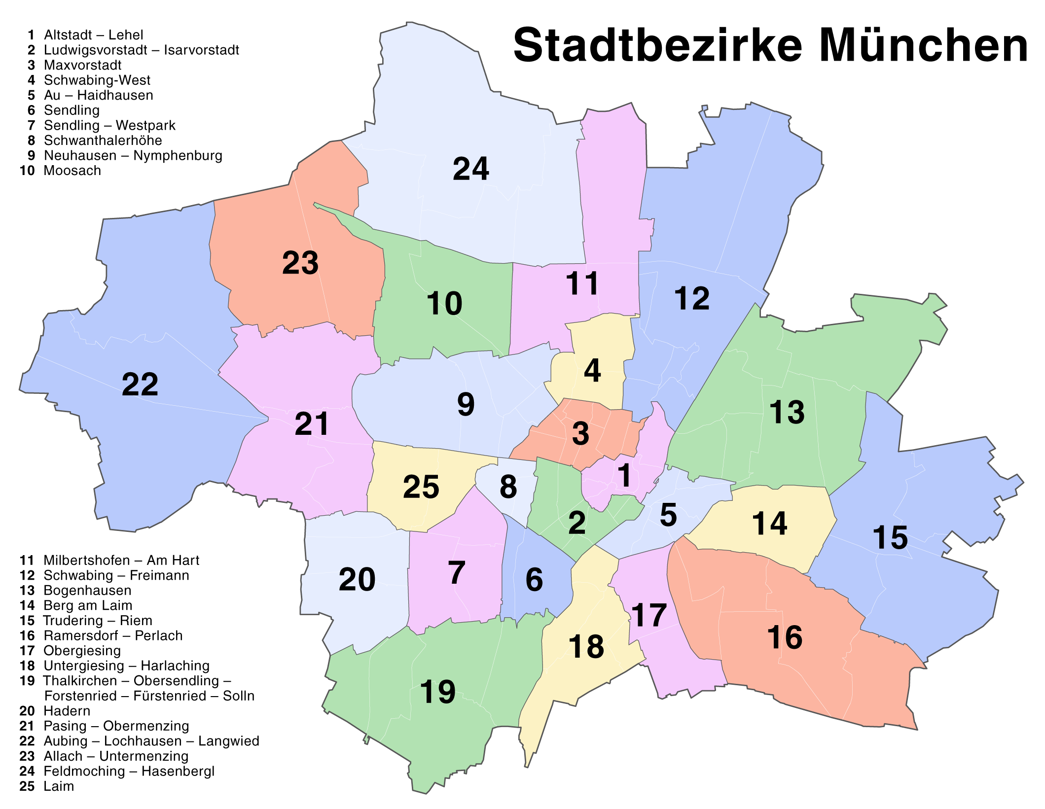
23 Allach-Untermenzing - 1 Altstadt-Lehel - 22 Aubing-Lochhausen-Langwied - 5 Au-Haidhausen - 14 Berg am Laim - 13 Bogenhausen - 24 Feldmoching-Hasenbergl - 20 Hadern - 25 Laim - 2 Ludwigsvorstadt-Isarvorstadt - 3 Maxvorstadt - 11 Milbertshofen-Am Hart - 10 Moosach - 9 Neuhausen-Nymphenburg - 17 Obergiesing - 21 Pasing-Obermenzing - 16 Ramersdorf-Perlach - 12 Schwabing-Freimann - 4 Schwabing-West - 8 Schwanthalerhöhe - 6 Sendling - 7 Sendling-Westpark - 19 Thalkirchen-Obersendling-Forstenried-Fürstenried-Solln - 15 Trudering-Riem - 18 Untergiesing-Harlaching
| Leírás |
Deutsch: Kartenserie der Münchner Stadtbezirke
English: Boroughs of Munich map series |
| Dátum | |
| Forrás | Self made, created with Adobe Illustrator 12.0 |
| Szerző | Maximilian Dörrbecker (Chumwa) |
| Engedély (Fájl újrafelhasználása) |
This map was created by Maximilian Dörrbecker. Attribution to Wikipedia or another project of the Wikimedia foundation is required if it is used outside of projects of the Wikimedia foundation. Ez a fájl a Creative Commons Nevezd meg! – Így add tovább! 2.5 Általános licenc alapján használható fel.
"I want to use the image. How do I do that?" You can use this map freely for any purpose, including commercial use, provided that you license it under the above license. My suggestion is to use the following text:
|
| Más változatok |
Die Serie besteht aus den folgenden Karten / The series consists of the following maps : Region München:
Stadt München:
|


.png)


.png)
.png)


_-_Altstadt_-_Lehel.png)
_-_Ludwigsvorstadt_-_Isarvorstadt.png)
_-_Maxvorstadt.png)
_-_Schwabing-West.png)
_-_Au_-_Haidhausen.png)
_-_Sendling.png)
_-_Sendling_-_Westpark.png)
_-_Schwanthalerh%C3%B6he.png)
_-_Neuhausen_-_Nymphenburg.png)
_-_Moosach.png)
_-_Milbertshofen_-_Am_Hart.png)
_-_Bogenhausen.png)
_-_Berg_am_Laim.png)
_-_Trudering_-_Riem.png)
_-_Ramersdorf_-_Perlach.png)
_-_Obergiesing.png)
_-_Thalkirchen_-_Obersendling_-_Forstenried_-_F%C3%BCrstenried_-_Solln.png)
_-_Hadern.png)
_-_Pasing_-_Obermenzing.png)
_-_Aubing_-_Lochhausen_-_Langwied.png)
_-_Allach_-_Untermenzing.png)
_-_Feldmoching_-_Hasenbergl.png)
_-_Laim.png)
.png)
Fájltörténet
Kattints egy időpontra, hogy a fájl akkori állapotát láthasd.
| Dátum/idő | Bélyegkép | Felbontás | Feltöltő | Megjegyzés | |
|---|---|---|---|---|---|
| aktuális | 2007. augusztus 20., 18:22 | | 2 119 × 1 641 (338 KB) | Chumwa | Correction of the district numbering in the named list (many thanks to Andreas for the error hint!) |
| 2007. augusztus 18., 18:16 |  | 2 119 × 1 641 (342 KB) | Chumwa | {{Information |Description= *{{ de }} Kartenserie der Münchner Stadtbezirke *{{ en }} Boroughs of Munich map series |Source=Self made, created with Adobe Illustrator 12.0 |Date=August 2007 |Author=Maximilian Dörrbecker ([[:de:User:Ch |
Fájlhasználat
Ezt a fájlt nem használja egyetlen lap sem.
Globális fájlhasználat
A következő wikik használják ezt a fájlt:
- Használata itt: ba.wikipedia.org
- Használata itt: bxr.wikipedia.org
- Használata itt: de.wikipedia.org
- Használata itt: en.wikipedia.org
- Használata itt: fr.wikipedia.org
- Használata itt: kk.wikipedia.org
- Használata itt: lez.wikipedia.org
- Használata itt: pl.wikivoyage.org
- Használata itt: ru.wikipedia.org
- Használata itt: vep.wikipedia.org
.png)