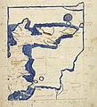
Fájl:Map after Ptolemy's Geographia (Burney MS 111, f.16r) (North Sea).jpeg

Eredeti fájl(3 926 × 4 335 képpont, fájlméret: 19,2 MB, MIME-típus: image/jpeg)

Összefoglaló

Cím
A collection of maps, in Greek, after Ptolemy's Geographia
Leírás
Latina: Albion insulae Britanniae
English: The eastern half of Ptolemy's First European Map in a Greek manuscript edition of the Geography, depicting Great Britain ("Alvion British Island")
Ἀρχαία ἑλληνικὴ: Ἀλουίωνος Νήσου Βριττανικῆς Θέσις: Ἀλουΐωνος Νῆσος Βρεττανική
British Library Shelfmark
InfoField
Burney MS 111, f.16r
Dátum
Forrás
This file has been provided by the British Library from its digital collections. A full catalogue record for the item shown is available on the British Library website.


This tag does not indicate the copyright status of the attached work. A normal copyright tag is still required. See Commons:Licensing.


বাংলা | Deutsch | English | español | euskara | français | galego | hrvatski | italiano | 日本語 | македонски | polski | русский | українська | 中文 | +/−

Alkotó
Engedély
(Fájl újrafelhasználása)
Public domain

Ez a mű közkincs abban az országban, ahol elkészítették, és minden olyan további államban, ahol a szerzői jogi védelmi idő a szerző élete plusz 70 év vagy kevesebb.


You must also include a United States public domain tag to indicate why this work is in the public domain in the United States. Note that a few countries have copyright terms longer than 70 years: Mexico has 100 years, Jamaica has 95 years, Colombia has 80 years, and Guatemala and Samoa have 75 years. This image may not be in the public domain in these countries, which moreover do not implement the rule of the shorter term. Honduras has a general copyright term of 75 years, but it does implement the rule of the shorter term. Copyright may extend on works created by French who died for France in World War II (more information), Russians who served in the Eastern Front of World War II (known as the Great Patriotic War in Russia) and posthumously rehabilitated victims of Soviet repressions (more information).

Georeferencing Georeference the map in Wikimaps Warper If inappropriate please set warp_status = skip to hide.
 Archival data
institution QS:P195,Q23308
Más változatok
image extraction process
Ez a fájl kivágás egy másik képből
: Map after Ptolemy's Geographia (Burney MS 111, f.16r).jpeg
original file
Képjegyzetek
InfoField
Ehhez a képhez képjegyzetek tartoznak: Képjegyzetek megtekintése a Commonson

Fájltörténet

Kattints egy időpontra, hogy a fájl akkori állapotát láthasd.

Dátum/időBélyegképFelbontásFeltöltőMegjegyzés
aktuális2021. szeptember 20., 16:20Bélyegkép a 2021. szeptember 20., 16:20-kori változatról3 926 × 4 335 (19,2 MB)GPinkertonFile:Map after Ptolemy's Geographia (Burney MS 111, f.16r).jpeg cropped 25 % horizontally, 37 % vertically using CropTool with lossless mode.

Az alábbi lap használja ezt a fájlt:

Globális fájlhasználat

A következő wikik használják ezt a fájlt:

  • Használata itt: de.wikipedia.org
  • Használata itt: nl.wikipedia.org

Metaadatok