Fájl:Map of Sendai Earthquake 2011.jpg

Eredeti fájl (897 × 749 képpont, fájlméret: 606 KB, MIME-típus: image/jpeg)
|
Ez a fájl a Wikimedia Commonsból származik. Az alább látható leírás az ottani dokumentációjának másolata. A Commons projekt szabad licencű kép- és multimédiatár. Segíts te is az építésében! |
Összefoglaló
| Leírás |
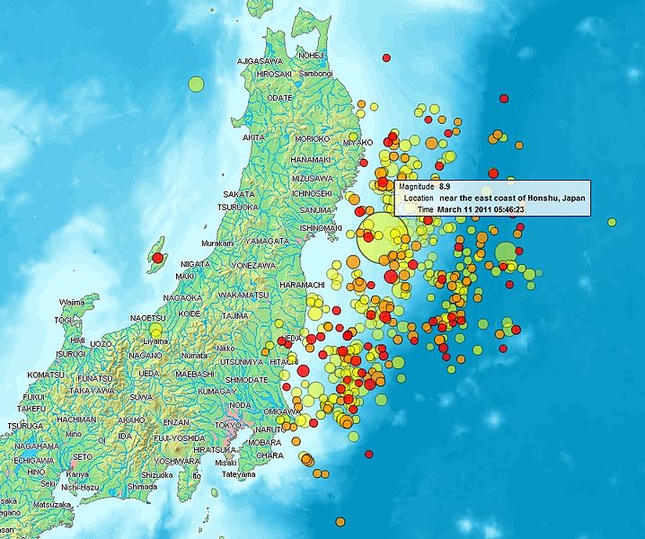
English: Map of the Sendai Earthquake 2011 and aftershocks until March 14, 2011 at 11:20. The size of the circles is a function of magnitude, and the color indicates the date: light green: March 11; yellow: March 12; orange: March 13; red: March 14.
Français : Carte des épicentres et de l'intensité des secousses du tremblement de terre de Sendai du 14 mars 2011. La taille des cercles est fonction de la magnitude, leur couleur indique la date : vert clair, 11.3.2011 ; jaune, 12.3.2011 ; orange, 13.3.2011 ; rouge 14.3.2011.
日本語: 2011年3月11日に発生した東北地方太平洋沖地震、および同14日11時20分までの余震を示した地図。円はマグニチュード、色は発生した日付(黄緑:3月11日、黄:3月12日、橙:3月13日、赤:3月14日)を示す。 |
| Dátum | |
| Forrás | http://www2.demis.nl/quakes/ |
| Szerző | www2.demis.nl, Uploader User:Heinz-Josef Lücking |
| Engedély (Fájl újrafelhasználása) |
Public domain according to http://www2.demis.nl |
|
Ez a mű közkincs abban az országban, ahol elkészítették, és minden olyan további államban, ahol a szerzői jogi védelmi idő a szerző élete plusz 70 év vagy kevesebb.
| |
| Megállapították, hogy ez a fájl mentes mindenféle szerzői jogi korlátozástól, beleértve az összes kapcsolódó és hozzátartozó jogot. | |
Licenc
This image is in the public domain because it came from the site https://www.demis.nl/products/web-map-server/examples/ and was released by the copyright holder. Permission is granted to copy, distribute and/or modify this map since it is based on free of copyright images from: www.demis.nl. See also approval email on de.wp and its clarification.
|
| This work has been released into the public domain by its copyright holder, www.demis.nl. This applies worldwide. Egyes országokban ez jogilag nem lehetséges. Ha így van, akkor: www.demis.nl jogot ad bárkinek, hogy bármilyen célból, feltétel nélkül használhassa ezt a fájlt, kivéve a törvény által kötelezően előírt feltételeket.
|
| Ez a fájl a Creative Commons CC0 1.0 Universal Public Domain Dedication licenc alatt lett közzétéve. | |
| A műhöz tartozó személy ezzel a dokumentummal a munkáját köztulajdonná tette. A törvények alapján megengedhető mértékig lemondott minden őt megillető jogról a szerzői jog és az összes kapcsolódó vagy vonatkozó törvény alapján, ami a munka alapján neki járna az egész világon. A CC0 alatt kiadott művek szerzőjét nem kell megjelölni. A munka hivatkozásakor nem kell jóváhagyást kérni a szerzőtől.
|
Fájltörténet
Kattints egy időpontra, hogy a fájl akkori állapotát láthasd.
| Dátum/idő | Bélyegkép | Felbontás | Feltöltő | Megjegyzés | |
|---|---|---|---|---|---|
| aktuális | 2011. március 14., 23:31 | | 897 × 749 (606 KB) | Heinz-Josef Lücking | 14.3 + legend description |
| 2011. március 13., 06:27 |  | 1 362 × 1 386 (1,41 MB) | Stanqo | 4h05m UTC, 13.03.2011 | |
| 2011. március 12., 13:10 |  | 1 197 × 1 245 (885 KB) | Yuma | higher resol. | |
| 2011. március 12., 12:27 |  | 928 × 694 (470 KB) | Yuma | update | |
| 2011. március 11., 19:20 |  | 1 006 × 773 (596 KB) | Heinz-Josef Lücking | actual 2011-03-11 18:20 | |
| 2011. március 11., 13:19 |  | 1 014 × 779 (598 KB) | Erdbeben20110311 | actuality | |
| 2011. március 11., 11:39 |  | 1 009 × 683 (522 KB) | Erdbeben20110311 | {{Information |Description ={{en|1=Map of the Senadai Earthquake 2011}} |Source =http://www2.demis.nl/quakes/ |Author =www2.demis.nl |Date =2011-03-11 |Permission = |other_versions = }} Public domain according to http://ww |
Fájlhasználat
Az alábbi lapok használják ezt a fájlt:
Globális fájlhasználat
A következő wikik használják ezt a fájlt:
- Használata itt: af.wikipedia.org
- Használata itt: als.wikipedia.org
- Használata itt: ar.wikipedia.org
- Használata itt: ast.wikipedia.org
- Használata itt: az.wikipedia.org
- Használata itt: bat-smg.wikipedia.org
- Használata itt: bcl.wikipedia.org
- Használata itt: be-tarask.wikipedia.org
- Használata itt: be.wikipedia.org
- Használata itt: ca.wikipedia.org
- Használata itt: cu.wikipedia.org
- Használata itt: da.wikipedia.org
- Használata itt: de.wikipedia.org
- Használata itt: el.wikipedia.org
- Használata itt: en.wikipedia.org
- Használata itt: en.wikibooks.org
- Használata itt: eo.wikipedia.org
- Használata itt: es.wikipedia.org
- Használata itt: es.wikinews.org
- Használata itt: eu.wikipedia.org
- Használata itt: fi.wikipedia.org
- Használata itt: fr.wikipedia.org
- Használata itt: ga.wikipedia.org
- Használata itt: he.wikipedia.org
- Használata itt: hr.wikipedia.org
- Használata itt: id.wikipedia.org
- Használata itt: is.wikipedia.org
- Használata itt: it.wikinews.org
- Használata itt: ja.wikipedia.org
- Használata itt: ko.wikipedia.org
- Használata itt: ksh.wikipedia.org
- Használata itt: lt.wikipedia.org
- Használata itt: mrj.wikipedia.org
- Használata itt: ms.wikipedia.org
- Használata itt: nl.wikipedia.org
- Használata itt: nn.wikipedia.org
- Használata itt: no.wikipedia.org
- Használata itt: oc.wikipedia.org
A fájl globális használatának megtekintése